Search results
From XMS Wiki
Jump to navigationJump to search
Page title matches
- ...er. They appear similar to stream feature arcs, but are not. On a TIN the streams are defined simply as connected vertices. ==Create Streams==4 KB (662 words) - 21:56, 30 December 2019
- #REDIRECT [[WMS:Streams]]25 bytes (3 words) - 17:13, 31 July 2013
- #REDIRECT [[WMS:Define and Smooth Streams]]43 bytes (6 words) - 20:06, 27 September 2013
- #REDIRECT [[WMS:Define and Smooth Streams]]43 bytes (6 words) - 20:06, 27 September 2013
- #REDIRECT [[WMS:Streams]]25 bytes (3 words) - 17:12, 31 July 2013
- #REDIRECT [[WMS:Streams]]25 bytes (3 words) - 17:11, 31 July 2013
- 38 bytes (5 words) - 16:03, 13 August 2013
- #REDIRECT [[WMS:Streams]]25 bytes (3 words) - 17:13, 31 July 2013
- #REDIRECT [[WMS:Streams]]25 bytes (3 words) - 17:12, 31 July 2013
- #REDIRECT [[WMS:Smooth GSSHA Streams]]38 bytes (5 words) - 22:47, 21 May 2019
- 38 bytes (5 words) - 16:04, 13 August 2013
- The ''Smooth GSSHA Streams'' dialog is accessible by selecting one or more reaches without branches an ...w in GSSHA has been significantly updated, and the process of creating the streams in WMS has been simplified.7 KB (1,152 words) - 18:02, 21 May 2021
File:Smooth GSSHA Streams dialog.png The smooth GSSHA streams dialog(499 × 667 (23 KB)) - 18:24, 3 November 2022- ...thumb|none|left|550 px|HY8 Modeling Wizard showing the ''Define and Smooth Streams'' step.]] When building a GSSHA model, define the parameters for and smooth all the streams in the model before building the 2D grid. When the 2D grid is generated, t2 KB (348 words) - 19:55, 4 May 2020
- |}<noinclude>[[Category:GMS Workflow Templates|Streams]]</noinclude>801 bytes (102 words) - 14:50, 6 June 2017
- #REDIRECT [[WMS:Smooth GSSHA Streams]]38 bytes (5 words) - 21:53, 21 May 2019
- 38 bytes (5 words) - 16:04, 13 August 2013
- #REDIRECT [[WMS:Define and Smooth Streams]]43 bytes (6 words) - 20:06, 27 September 2013
- #REDIRECT [[WMS:Define and Smooth Streams]]43 bytes (6 words) - 20:06, 27 September 2013
- #REDIRECT [[WMS:Define and Smooth Streams]]43 bytes (6 words) - 20:06, 27 September 2013
- #REDIRECT [[WMS:Define and Smooth Streams]]43 bytes (6 words) - 20:06, 27 September 2013

Page text matches
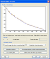
File:SmoothStreams.png The smooth GSSHA streams dialog See also [[File:Smooth GSSHA Streams dialog.png|thumb|none]](503 × 593 (20 KB)) - 18:40, 22 May 2019
File:RoadAsStreamsDelineation.png ...neation after including the roads as streams. It is important to note that streams have been made in both directions from the outlets in order to "capture" th(800 × 295 (403 KB)) - 15:52, 7 December 2016- #REDIRECT [[WMS:Streams]]25 bytes (3 words) - 17:13, 31 July 2013
- #REDIRECT [[WMS:Streams]]25 bytes (3 words) - 17:12, 31 July 2013
- #REDIRECT [[WMS:Streams]]25 bytes (3 words) - 17:13, 31 July 2013
- #REDIRECT [[WMS:Streams]]25 bytes (3 words) - 17:12, 31 July 2013
- #REDIRECT [[WMS:Streams]]25 bytes (3 words) - 17:13, 31 July 2013
- #REDIRECT [[WMS:Streams]]25 bytes (3 words) - 17:12, 31 July 2013
- #REDIRECT [[WMS:Streams]]25 bytes (3 words) - 17:12, 31 July 2013
- #REDIRECT [[WMS:Streams]]25 bytes (3 words) - 17:12, 31 July 2013
- #REDIRECT [[WMS:Streams]]25 bytes (3 words) - 17:12, 31 July 2013
- #REDIRECT [[WMS:Streams]]25 bytes (3 words) - 17:12, 31 July 2013
- #REDIRECT [[WMS:Streams]]25 bytes (3 words) - 17:13, 31 July 2013
- #REDIRECT [[WMS:Streams]]25 bytes (3 words) - 17:12, 31 July 2013
- #REDIRECT [[WMS:Streams]]25 bytes (3 words) - 17:12, 31 July 2013
- #REDIRECT [[WMS:Streams]]25 bytes (3 words) - 17:12, 31 July 2013
- #REDIRECT [[WMS:Streams]]25 bytes (3 words) - 17:11, 31 July 2013
- #REDIRECT [[WMS:Streams]]25 bytes (3 words) - 17:13, 31 July 2013
- #REDIRECT [[WMS:Smooth GSSHA Streams]]38 bytes (5 words) - 21:58, 21 May 2019
- #REDIRECT [[WMS:Smooth GSSHA Streams]]38 bytes (5 words) - 21:58, 21 May 2019
- #REDIRECT [[WMS:Smooth GSSHA Streams]]38 bytes (5 words) - 21:58, 21 May 2019
- #REDIRECT [[WMS:Smooth GSSHA Streams]]38 bytes (5 words) - 21:59, 21 May 2019
- #REDIRECT [[WMS:Smooth GSSHA Streams]]38 bytes (5 words) - 21:54, 21 May 2019
- #REDIRECT [[WMS:Smooth GSSHA Streams]]38 bytes (5 words) - 21:59, 21 May 2019
- #REDIRECT [[WMS:Smooth GSSHA Streams]]38 bytes (5 words) - 21:53, 21 May 2019
- #REDIRECT [[WMS:Smooth GSSHA Streams]]38 bytes (5 words) - 21:59, 21 May 2019
- #REDIRECT [[WMS:Smooth GSSHA Streams]]38 bytes (5 words) - 22:47, 21 May 2019
- #REDIRECT [[WMS:Smooth GSSHA Streams]]38 bytes (5 words) - 21:59, 21 May 2019
- #REDIRECT [[WMS:Define and Smooth Streams]]43 bytes (6 words) - 20:06, 27 September 2013
- #REDIRECT [[WMS:Define and Smooth Streams]]43 bytes (6 words) - 20:06, 27 September 2013
- #REDIRECT [[WMS:Define and Smooth Streams]]43 bytes (6 words) - 20:06, 27 September 2013
- #REDIRECT [[WMS:Define and Smooth Streams]]43 bytes (6 words) - 20:06, 27 September 2013
- #REDIRECT [[WMS:Define and Smooth Streams]]43 bytes (6 words) - 20:06, 27 September 2013
- #REDIRECT [[WMS:Define and Smooth Streams]]43 bytes (6 words) - 20:06, 27 September 2013
- #REDIRECT [[WMS:Define and Smooth Streams]]43 bytes (6 words) - 20:06, 27 September 2013
- #REDIRECT [[WMS:Define and Smooth Streams]]43 bytes (6 words) - 20:06, 27 September 2013
- ...t drainage features such as streams. By using GIS Vector data to establish streams and a "rough" boundary, a TIN well-suited for basin delineation can be crea575 bytes (84 words) - 15:51, 11 April 2017
- #REDIRECT [[WMS:Smooth GSSHA Streams#GSSHA Thalweg]]52 bytes (7 words) - 19:22, 22 May 2019
- #REDIRECT [[WMS:Smooth GSSHA Streams#GSSHA Thalweg]]52 bytes (7 words) - 19:23, 22 May 2019
- #REDIRECT [[WMS:Smooth GSSHA Streams#GSSHA Thalweg]]52 bytes (7 words) - 19:24, 22 May 2019
- ...thumb|none|left|550 px|HY8 Modeling Wizard showing the ''Define and Smooth Streams'' step.]] When building a GSSHA model, define the parameters for and smooth all the streams in the model before building the 2D grid. When the 2D grid is generated, t2 KB (348 words) - 19:55, 4 May 2020
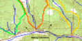
File:TOPAZ Delineation.png Delineation from the TOPAZ results only (not including the roads as streams)(688 × 343 (64 KB)) - 15:52, 7 December 2016File:Smooth GSSHA Streams dialog.png The smooth GSSHA streams dialog(499 × 667 (23 KB)) - 18:24, 3 November 2022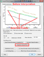
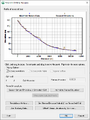
File:GsshaStormDrainElevationInterpFig2.png The Interpolate Selected Points button in the GSSHA Smooth Streams dialog(513 × 673 (30 KB)) - 14:38, 5 June 2019
File:HydrologicModelingWizardDefineAndSmoothStreams.jpg HY8 Modeling Wizard showing the Define and Smooth Streams step.(679 × 514 (76 KB)) - 15:58, 15 December 2015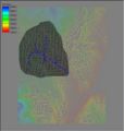
File:Tin3.jpg By using GIS Vector data to establish streams and a "rough" boundary, a TIN well-suited for basin delineation can be crea(350 × 368 (31 KB)) - 16:27, 9 January 2017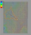
File:Demtofobj.jpg ...using a DEM, the results are always converted to points (outlets), lines (streams), and polygons (boundaries) for more convenient data storage and manipulati(350 × 400 (56 KB)) - 15:39, 9 January 2017- The ''Watershed from Raster'' tool derives a watershed and its streams locations from an elevation raster and one or more outlet locations. This i ...t_book/available_tools/stream_network_analysis.html#ExtractStreams Extract Streams]''4 KB (515 words) - 19:40, 26 October 2023
- * [[WMS:Streams|Streams]]1 KB (160 words) - 23:05, 30 December 2019
- ...using a DEM, the results are always converted to points (outlets), lines (streams), and polygons (boundaries) for more convenient data storage and manipulati468 bytes (66 words) - 15:50, 11 April 2017


