WMS:Quick Tour -Maricopa County Hydrology in WMS: Difference between revisions
From XMS Wiki
Jump to navigationJump to search
No edit summary |
No edit summary |
||
| (3 intermediate revisions by the same user not shown) | |||
| Line 1: | Line 1: | ||
The WMS developers have worked closely with hydrologists from the Maricopa County Flood Control District to automate some of the GIS operations done there in support of the HEC-1 model. These options include: | The WMS developers have worked closely with hydrologists from the Maricopa County Flood Control District to automate some of the GIS operations done there in support of the HEC-1 model. These options include: | ||
*Inclusion of the Maricopa Country time of concentration equation in the list of available equations | |||
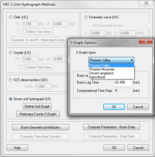
*Ability to create unit hydrographs from S-graphs used as standards in the area | |||
*Automatic calculation of average precipitation and rainfall distribution based on rainfall grid | |||
[[Image:S-GraphOptionsQuick.jpg]] | |||
[[Image: | |||
[[WMS:Quick Tour -LA County Hydrology in WMS| '''< Previous''']] | [[WMS:Quick Tour -HEC-RAS| ''' Next >''']] | [[WMS:Quick Tour -LA County Hydrology in WMS| '''< Previous''']] | [[WMS:Quick Tour -HEC-RAS| ''' Next >''']] | ||
[[Category:WMS Quick Tour| | [[Category:WMS Quick Tour|Maricopa]] | ||
Latest revision as of 16:01, 6 January 2017
The WMS developers have worked closely with hydrologists from the Maricopa County Flood Control District to automate some of the GIS operations done there in support of the HEC-1 model. These options include:
- Inclusion of the Maricopa Country time of concentration equation in the list of available equations
- Ability to create unit hydrographs from S-graphs used as standards in the area
- Automatic calculation of average precipitation and rainfall distribution based on rainfall grid
