Template:SMS at a glance gis module: Difference between revisions
From XMS Wiki
Jump to navigationJump to search
m (Protected "Template:SMS at a glance gis module" ([Edit=Allow only administrators] (indefinite) [Move=Allow only administrators] (indefinite))) |
No edit summary |
||
| (4 intermediate revisions by the same user not shown) | |||
| Line 1: | Line 1: | ||
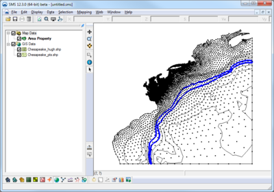
[[Image:GIS Data in SMS. | [[Image:GIS Data in SMS.png|thumb|400px|right|GIS data in SMS]] | ||
{{{Heading}}} | {{{Heading}}} | ||
* Open and visualize GIS data | * Open and visualize GIS data | ||
* Supports ESRI and MapInfo formats | * Supports ESRI and MapInfo formats | ||
* Uses Mapobjects for ESRI files if available to use ArcGIS visualization options | * Uses Mapobjects for ESRI files if available to use ArcGIS visualization options | ||
* Open and visualize raster data | |||
* GIS data can be converted to feature data (map module) | * GIS data can be converted to feature data (map module) | ||
* Convert raster to TIN (scatter set) | |||
* Interpolate data from raster to TINs /2D mesh/2D grid | |||
{{{Link|}}} | {{{Link|}}} | ||
<br style="clear:both;"/><noinclude>[[Category:SMS at a glance]]</noinclude> | <br style="clear:both;"/><noinclude>[[Category:SMS at a glance|gis]][[Category:SMS GIS]]</noinclude> | ||
Latest revision as of 16:41, 10 October 2017
{{{Heading}}}
- Open and visualize GIS data
- Supports ESRI and MapInfo formats
- Uses Mapobjects for ESRI files if available to use ArcGIS visualization options
- Open and visualize raster data
- GIS data can be converted to feature data (map module)
- Convert raster to TIN (scatter set)
- Interpolate data from raster to TINs /2D mesh/2D grid
