WMS:Define Project Bounds: Difference between revisions
(→Help) |
|||
| Line 1: | Line 1: | ||
== Overview == | == Overview == | ||
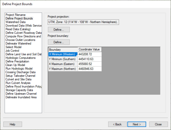
[[Image:HydrologicModelingWizardDefineProjectBounds.jpg]] | [[Image:HydrologicModelingWizardDefineProjectBounds.jpg|thumb|none|left|550 px|HY8 Modeling Wizard showing the ''Define Project Bounds'' step.]] | ||
The define project bounds step is used for defining your project boundary. | The define project bounds step is used for defining your project boundary. | ||
Revision as of 19:29, 25 September 2013
Overview
The define project bounds step is used for defining your project boundary.
Help
Top Define button – This button is used to define your project coordinate system, if it is known. Bottom Define button - This button is used to define your project boundary in the Microsoft Virtual Earth web service client. Find the area you are interested in modeling and WMS will enter the minimum and maximum coordinates of the box you have defined in the Virtual Earth window.
Hydrologic Modeling Wizard Steps: Project Filename · Define Project Bounds · Watershed Data · Download Data (Web Service Client) · Read Data (Catalog) · Compute Flow Directions and Flow Accumulations · Choose Outlet Locations · Delineate Watershed · Select Model · Define and Smooth Streams · Create 2D Grid · Job Control · Define Land Use and Soil Data · Hydrologic Computations · Define Precipitation · Clean Up Model · Run Hydrologic Model
HY8 Modeling Wizard Steps: Project Filename · Define Project Bounds · Watershed Data · Download Data (Web Service Client) · Read Data (Catalog) · Define Culvert Roadway Data · Compute Flow Directions and Flow Accumulations · Choose Outlet Locations · Delineate Watershed · Select Model · Job Control · Define Land Use and Soil Data · Hydrologic Computations · Define Precipitation · Clean Up Model · Run Hydrologic Model · Crossing Discharge Data · Setup Tailwater Channel · Culvert and Site Data · Run Culvert Analysis · Define Flood Inundation Polygon · Storage Capacity Data · Define Upstream Channel · Delineate Inundated Area
WMS – Watershed Modeling System | ||
|---|---|---|
| Modules: | Terrain Data • Drainage • Map • Hydrologic Modeling • River • GIS • 2D Grid • 2D Scatter |  |
| Models: | CE-QUAL-W2 • GSSHA • HEC-1 • HEC-HMS • HEC-RAS • HSPF • MODRAT • NSS • OC Hydrograph • OC Rational • Rational • River Tools • Storm Drain • SMPDBK • SWMM • TR-20 • TR-55 | |
| Toolbars: | Modules • Macros • Units • Digitize • Static Tools • Dynamic Tools • Drawing • Get Data Tools | |
| Aquaveo | ||
