HY8:Water Surface Profiles: Difference between revisions
From XMS Wiki
Jump to navigationJump to search
No edit summary |
m (Jcreer moved page HY-8:Water Surface Profiles to HY8:Water Surface Profiles) |
||
| (4 intermediate revisions by the same user not shown) | |||
| Line 15: | Line 15: | ||
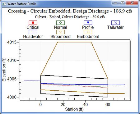
While viewing the water surface profiles table, the user may plot any of the profiles by selecting the desired profile in the table and clicking the water profile button in the window. Below is a sample water surface profile for a circular culvert. | While viewing the water surface profiles table, the user may plot any of the profiles by selecting the desired profile in the table and clicking the water profile button in the window. Below is a sample water surface profile for a circular culvert. | ||
[[Image: | [[Image:HY8 WaterSurfaceProfile.jpg|thumb|none|450 px|Water surface profile for a circular culvert]] | ||
| Line 23: | Line 22: | ||
{{HY8Main}} | {{HY8Main}} | ||
[[Category:HY-8 Analysis|W]] | [[Category:HY-8 Analysis|W]] | ||
[[Category:HY-8 Dialogs]] | [[Category:HY-8 Dialogs|water]] | ||
Latest revision as of 15:30, 7 October 2016
Water surface profile information is displayed in a table format for each of the discharge values. Once a profile is selected, plot and view the profile. The following parameters are displayed in the water surface profiles table:
- Total Discharge: Total discharge at the culvert crossing
- Culvert Discharge: Amount of discharge that passes through the culvert barrel(s)
- Headwater Elevation: Computed headwater elevation at the inlet of the culvert
- Inlet Control Depth: Headwater depth above inlet invert assuming inlet control
- Outlet Control Depth: Headwater depth above inlet invert assuming outlet control
- Flow Type: USGS flow type 1 through 7 is indicated and the associated profile shape and boundary condition. Press the Flow Types button for a summary of Flow Types
- Length Full: Length of culvert that is flowing full.
- Length Free: Length of culvert that has free surface flow.
- Last Step: Last length increment calculated in profile.
- Mean Slope: Last mean water surface slope calculated.
- First Depth: Starting depth for water surface profile.
- Last Depth: Ending depth for the water surface profile.
While viewing the water surface profiles table, the user may plot any of the profiles by selecting the desired profile in the table and clicking the water profile button in the window. Below is a sample water surface profile for a circular culvert.
