User:Mburton/HydroGeoSphere Arc Properties Dialog
| This contains information currently under development. The content may change often. |
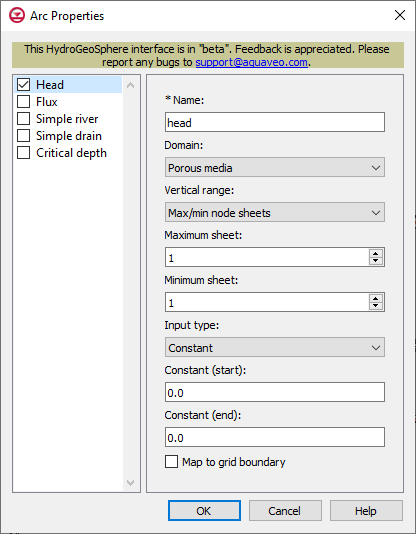
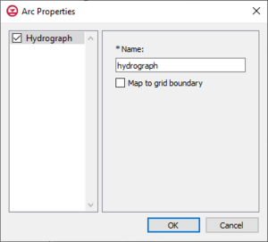
The Arc Properties dialog is where the parameters for an arc in a boundary conditions or hydrograph coverage are defined in a HydrGeoSphere model. Only one type of boundary condition can be assigned to a feature object on a boundary conditions coverage. For hydrograph coverages, "Hydrograph" is the only option available to assign to a feature object.
Head or Flux, Boundary Conditions Coverage
Head and flux are two separate available arc property types on a boundary conditions coverage, but the input options available are the same. Head is a general specified head boundary condition, and flux is a general specified flux boundary condition. The input options for head and flux are listed below.
- Name
- Domain | Porous media – The domain in which the boundary condition is applied.
- Minimum sheet – Boundary conditions will be applied between the minimum and maximum node sheets.
- Maximum sheet – Boundary conditions will be applied between the minimum and maximum node sheets.
- Input type – How the boundary condition data is specified.
- Constant
- Constant (start) – Constant value of the boundary condition at the start of the arc.
- Constant (end) – Constant value of the boundary condition at the end of the arc.
- Time series
- Time series (start) – Time-varying values of the boundary condition at the start of the arc.
- Time series (end) – Time-varying values of the boundary condition at the end of the arc.
- Interpolate – Causes time-varying values to be interpolated, resulting in a smoother application of the time-varying function.
- Map to grid boundary – Map boundary condition to the boundary of the grid (not the interior).
- Constant
- Domain | Surface flow – The domain in which the boundary condition is applied.
- Input type – How the boundary condition data is specified.
- Constant
- Constant (start) – Constant value of the boundary condition at the start of the arc.
- Constant (end) – Constant value of the boundary condition at the end of the arc.
- Map to grid boundary – Map boundary condition to the boundary of the grid (not the interior).
- Time series
- Time series (start) – Time-varying values of the boundary condition at the start of the arc.
- Time series (end) – Time-varying values of the boundary condition at the end of the arc.
- Interpolate – Causes time-varying values to be interpolated, resulting in a smoother application of the time-varying function.
- Map to grid boundary – Map boundary condition to the boundary of the grid (not the interior).
- Constant
- Input type – How the boundary condition data is specified.
Simple River or Simple Drain, Boundary Conditions Coverage
Simple river and simple drain are two separate available arc property types on a boundary conditions coverage, but the input options available are the same. Simple river is a river flux drainage boundary condition, and simple drain is a drain flux drainage boundary condition. The input options for simple river and simple drain are listed below.
- Name
- Input type – How the boundary condition data is specified.
- Constant
- Constant (start) – Constant value of the boundary condition at the start of the arc.
- Constant (end) – Constant value of the boundary condition at the end of the arc.
- Map to grid boundary – Map boundary condition to the boundary of the grid (not the interior).
- Time series
- Time series (start) – Time-varying values of the boundary condition at the start of the arc.
- Time series (end) – Time-varying values of the boundary condition at the end of the arc.
- Interpolate – Causes time-varying values to be interpolated, resulting in a smoother application of the time-varying function.
- Map to grid boundary – Map boundary condition to the boundary of the grid (not the interior).
- Constant
Critical Depth, Boundary Conditions Coverage
The critical depth boundary condition determines the rate at which mass is leaving the model domain.
- Name
- Transient – Define a time value table to turn the boundary condition on and off. Values of -99999 indicate that the BC is turned off.
- Time series – Time value table. Values of -99999 indicate that the BC is turned off.
- Map to grid boundary – Map boundary condition to the boundary of the grid (not the interior).
Hydrograph, Hydrograph Coverage
Assigning "hydrograph" to an arc on a hydrograph coverage in a HydroGeoSphere model allows GMS to record hydrograph data during the model run.
- Name – A descriptive name for the hydrograph, which can be up to 80 characters.
- Map to grid boundary – Map grid to the boundary of the grid, not the interior.

