AHGW:HGU Color Manager: Difference between revisions
From XMS Wiki
Jump to navigationJump to search
m (Move page script moved page AHGW:HGU Color Manager to Test:HGU Color Manager without leaving a redirect) |
No edit summary |
||
| Line 1: | Line 1: | ||
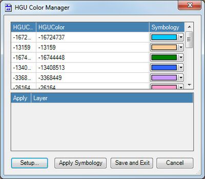
[[File:AHGW HGU Color Manager dialog.jpg|thumb|400px|right|HGU Color Manager helps create integrated maps and scenes using a single color scheme]] | [[File:AHGW HGU Color Manager dialog.jpg|thumb|400px|right|HGU Color Manager helps create integrated maps and scenes using a single color scheme]] | ||
The HGU Color Manager is a | The ''HGU Color Manager'' dialog is accessed by selecting ''Subsurface'' | '''HGU Color Manager''' from the [[AHGW:Arc Hydro Groundwater Toolbar|Arc Hydro Groundwater Toolbar]]. It can also be accessed via a button at the bottom of the [[AHGW:Borehole/Well Editor|''Borehole/Well Editor'' dialog]]. | ||
This dialog allows for managing the symbology of layers based on a common attribute using a single interface. The tool is based on the "HydrogeologicUnit" table which defines a set of conceptual hydrogeologic units that are associated with different spatial instances such as volumes, cross sections, borehole intervals, geologic picks, and outcrops. | |||
{{Navbox AHGW}} | {{Navbox AHGW}} | ||
[[Category:AHGW Subsurface Analyst]] | [[Category:AHGW Subsurface Analyst]] | ||
Revision as of 01:11, 14 November 2019
The HGU Color Manager dialog is accessed by selecting Subsurface | HGU Color Manager from the Arc Hydro Groundwater Toolbar. It can also be accessed via a button at the bottom of the Borehole/Well Editor dialog.
This dialog allows for managing the symbology of layers based on a common attribute using a single interface. The tool is based on the "HydrogeologicUnit" table which defines a set of conceptual hydrogeologic units that are associated with different spatial instances such as volumes, cross sections, borehole intervals, geologic picks, and outcrops.

