File:AreaBetweenElevationsQuick.jpg: Difference between revisions
From XMS Wiki
Jump to navigationJump to search
No edit summary |
No edit summary |
||
| Line 2: | Line 2: | ||
WMS includes a general tool to compute the area between specified elevations (contours). This information is particularly important for snowmelt analysis such as can be done using HEC-1. | WMS includes a general tool to compute the area between specified elevations (contours). This information is particularly important for snowmelt analysis such as can be done using HEC-1. | ||
[[Category:Needs Update]] | |||
Revision as of 15:29, 29 May 2015
WMS includes a general tool to compute the area between specified elevations (contours). This information is particularly important for snowmelt analysis such as can be done using HEC-1.
File history
Click on a date/time to view the file as it appeared at that time.
| Date/Time | Thumbnail | Dimensions | User | Comment | |
|---|---|---|---|---|---|
| current | ★ Approved revision 17:12, 20 August 2007 | 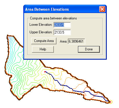 | 409 × 373 (53 KB) | Trabadi (talk | contribs) |
You cannot overwrite this file.
File usage
The following page uses this file: