File:SMPDBK2.png: Difference between revisions
From XMS Wiki
Jump to navigationJump to search
No edit summary |
No edit summary |
||
| Line 1: | Line 1: | ||
[[Category:SMPDBK]] | [[Category:SMPDBK]] | ||
An Area Property Coverage that consists of polygons corresponding to the different land use (roughness) types found in the floodplain. After building the coverage, the user will need to define each polygon attribute by double-clicking on the polygon and assigning the appropriate roughness value. Generally these polygons will be a more generalized version of a land use map. | |||
Revision as of 14:51, 12 September 2014
An Area Property Coverage that consists of polygons corresponding to the different land use (roughness) types found in the floodplain. After building the coverage, the user will need to define each polygon attribute by double-clicking on the polygon and assigning the appropriate roughness value. Generally these polygons will be a more generalized version of a land use map.
File history
Click on a date/time to view the file as it appeared at that time.
| Date/Time | Thumbnail | Dimensions | User | Comment | |
|---|---|---|---|---|---|
| current | ★ Approved revision 14:58, 5 June 2008 | 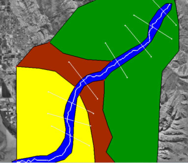 | 383 × 333 (119 KB) | Eshaw (talk | contribs) |
You cannot overwrite this file.
File usage
The following page uses this file: