File:TerrainProjectExplorer4.png: Difference between revisions
From XMS Wiki
Jump to navigationJump to search
m (Jcreer moved page File:Image203.png to File:TerrainProjectExplorer4.png) |
(cat) |
||
| Line 1: | Line 1: | ||
[[Category:Terrain Data]] | [[Category:Terrain Data]] | ||
[[Category: | [[Category:Project Explorer images]] | ||
Right-clicking on a dataset of a TIN allows the user to Delete, Export, Rename, view Properties, View values, set the dataset as elevations, or set the dataset contour options. | Right-clicking on a dataset of a TIN allows the user to Delete, Export, Rename, view Properties, View values, set the dataset as elevations, or set the dataset contour options. | ||
Revision as of 18:06, 10 July 2015
Right-clicking on a dataset of a TIN allows the user to Delete, Export, Rename, view Properties, View values, set the dataset as elevations, or set the dataset contour options.
File history
Click on a date/time to view the file as it appeared at that time.
| Date/Time | Thumbnail | Dimensions | User | Comment | |
|---|---|---|---|---|---|
| current | ★ Approved revision 16:30, 8 March 2018 | 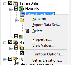 | 228 × 210 (9 KB) | Jcreer (talk | contribs) | |
| 20:53, 19 March 2013 |  | 231 × 232 (12 KB) | Cmsmemoe (talk | contribs) |
You cannot overwrite this file.
File usage
The following page uses this file: