|
|
| (17 intermediate revisions by 3 users not shown) |
| Line 1: |
Line 1: |
| {{Boreholes links}} | | {{Boreholes links}} |
| Hydrogeologic units (HGUs) can be defined on boreholes. HGUs are typically a simplified representation of the soil layers from the borehole field data. For example, the borehole log may include several types of sand ("brown sand", "gray silty sand", "clean sand"), but for modeling purposes, you may want to treat these all as one material, "sand". Now you can show both the original soils and the simplified HGUs on the boreholes. | | Hydrogeologic units (HGUs) can be defined on boreholes. HGUs are typically a simplified representation of the soil layers from the borehole field data. For example, the borehole log may include several types of sand ("brown sand", "gray silty sand", "clean sand"), but for modeling purposes, treat these all as one [[GMS:Materials|material]], "sand". GMS now shows both the original soils and the simplified HGUs on the boreholes. |
|
| |
|
| '''Borehole Editor''' - The HGU and soil IDs can be edited using the Borehole Editor.
| | ==Importing Borehole Data== |
| | When [[GMS:File Import Wizard|importing]] borehole data, both an HGU and Soil ID column can be [[GMS:File Import Wizard Supported File Formats#Borehole data|specified]] in the input. Files containing only a single set of materials can be imported to either field and the other field can be populated using the conversion tools described below. |
|
| |
|
| '''Display in Main Window''' - The boreholes can be displayed in the main graphics window using either the HGU IDs or the soil IDs. The ID used for display can be selected in the Borehole Display Options dialog.
| | ==Creation== |
| | The HGU and soil IDs can be edited using the [[GMS:Creating and Editing Boreholes|''Borehole Editor'']]. |
|
| |
|
| [[Image:Hydrogeologic_Unit_Display.gif|left|frame|Borehole Display Options]] | | ==Display== |
| | The boreholes can be displayed in the main graphics window using either the HGU IDs or the soil IDs. The ID used for display can be selected in the [[GMS:Borehole Display Options|''Display Options'']] dialog. |
|
| |
|
| '''Importing Borehole Data''' - When importing borehole data, both an HGU and Soil ID column can be used in the input. Files containing only a single set of materials can be imported to either field and the other field can be populated using the conversion tools described below.
| | :[[Image:Hydrogeologic_Unit_Display.png|none|frame|Borehole display options]] |
|
| |
|
| '''Converting Materials''' - A set of soil IDs can be converted to a set of HGU IDs using the '''''Soils->HGUs''''' command in the Borehole menu. Likewise, a set of HGU IDs can be converted to a set of soil IDs using the '''''HGUs->Soils''''' command.
| | ==Soils → HGUs, HGUs → Soils== |
| | A set of soil IDs can be converted to a set of HGU IDs using the '''Soils→HGUs''' command in the ''Borehole'' menu. Likewise, a set of HGU IDs can be converted to a set of soil IDs using the '''HGUs→Soils''' command. |
| | |
| | ==Building Cross Sections, Solids== |
| | When building cross sections or solid models using boreholes, the HGU IDs are used by GMS. The soil IDs are used purely for visualization or for setting up the HGU IDs. |
|
| |
|
| '''Building Cross-Sections, Solids''' - When building cross-sections or solid models using boreholes, the HGU IDs are used by GMS. The soil IDs are used purely for visualization or for setting up the HGU IDs.
| |
|
| |
|
| {{Navbox GMS}} | | {{Navbox GMS}} |
| [[Category:Boreholes]] | | [[Category:Boreholes|Hydro]] |
Hydrogeologic units (HGUs) can be defined on boreholes. HGUs are typically a simplified representation of the soil layers from the borehole field data. For example, the borehole log may include several types of sand ("brown sand", "gray silty sand", "clean sand"), but for modeling purposes, treat these all as one material, "sand". GMS now shows both the original soils and the simplified HGUs on the boreholes.
Importing Borehole Data
When importing borehole data, both an HGU and Soil ID column can be specified in the input. Files containing only a single set of materials can be imported to either field and the other field can be populated using the conversion tools described below.
Creation
The HGU and soil IDs can be edited using the Borehole Editor.
Display
The boreholes can be displayed in the main graphics window using either the HGU IDs or the soil IDs. The ID used for display can be selected in the Display Options dialog.
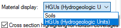
Borehole display options
Soils → HGUs, HGUs → Soils
A set of soil IDs can be converted to a set of HGU IDs using the Soils→HGUs command in the Borehole menu. Likewise, a set of HGU IDs can be converted to a set of soil IDs using the HGUs→Soils command.
Building Cross Sections, Solids
When building cross sections or solid models using boreholes, the HGU IDs are used by GMS. The soil IDs are used purely for visualization or for setting up the HGU IDs.

