Search results
From XMS Wiki
Jump to navigationJump to search

File:Drainage Module Icon.svg Drainage Module icon in WMS. Replacing [[File:Drainage Module icon in WMS.png]](60 × 64 (5 KB)) - 20:36, 15 November 2017
File:Hydraulic Module Icon.svg Icon for the Hydraulic Modeling Module (river module) in WMS. Replacing [[File:Hydraulic Modeling Module icon in WMS.png]](49 × 60 (5 KB)) - 15:40, 8 June 2017
File:SMS Select Nodestring Tool.svg [[Category:Nodes, Points, and Vertices Icons]] [[Category:Arc and Line Icons]](60 × 51 (3 KB)) - 16:17, 6 November 2017
File:WMSIcon 2D Scatter Point Module.png 2-D Scatter Point Module icon for WMS. [[Category:Module Icons]](16 × 16 (410 bytes)) - 20:48, 2 March 2018
File:Hydraulic Modeling Module icon in WMS.png Icon for the Hydraulic Modeling Module (river module) in WMS. [[Category:Module Icons]](13 × 16 (423 bytes)) - 18:46, 18 June 2018
File:WMSIcon Select Feature Vertex.png [[Category:Arc and Line Icons]] [[Category:Map Icons]](16 × 16 (546 bytes)) - 16:45, 16 January 2018
File:Annotation Module Icon.svg Icon for the Annotations Module in SMS. [[Category:Module Icons]](60 × 61 (4 KB)) - 14:08, 19 September 2017
File:WMS SelectVertexTool.svg [[Category:Arc and Line Icons]] [[Category:Map Icons]](60 × 66 (4 KB)) - 16:45, 16 January 2018
File:UGrid Icon Unlocked.svg Icon for the UGrid module in SMS [[Category:Module Icons]](56 × 60 (4 KB)) - 14:45, 14 August 2017
File:WMS TerrainIcon.svg Icon for the WMS Terrain Data module. Replacing [[File:WMSIcon Terrain Data Module.png]](60 × 60 (6 KB)) - 21:40, 22 March 2018
File:WMSIcon Select Hydraulic Link.png [[Category:Triangle Icons]] [[Category:WMS Hydraulic Modeling Module Tool Icons]](11 × 16 (491 bytes)) - 16:26, 19 January 2018
File:2D Grid Icon.svg Icon used for the Cartesian/2-D Grid Module in XMS (GMS, SMS, and WMS). Replacing [[File:2D Grid Module icon.png]](60 × 60 (7 KB)) - 16:50, 27 July 2017
File:Hydrologic Module Icon.svg WMS Hydrologic Modeling module icon. Also used as the Hydrologic Coverage Tree icon in the Project Explore Replacing [[File:Hydrologic Modeling Module in WMS.png]](56 × 60 (9 KB)) - 15:32, 8 June 2017
File:Solid Module Icon.svg Icon for the Solid module. [[Category:Project Explorer Icons]](60 × 60 (5 KB)) - 14:14, 21 August 2017
File:2D Mesh Icon.svg Icon for the 2D Mesh Module in GMS and SMS. [[Category:Module Icons]](56 × 60 (4 KB)) - 14:21, 29 August 2017
File:WMSIcon Select Feature Point.png [[Category:Arc and Line Icons]] [[Category:Map Icons]](16 × 16 (502 bytes)) - 16:47, 16 January 2018
File:GMS Select Triangle Tool.svg [[Category:Mesh Icons]] [[Category:Triangle Icons]](60 × 59 (3 KB)) - 14:38, 23 August 2017
File:WMS SelectHydrographTool.svg [[Category:WMS Hydrologic Modeling Module Tool Icons]] [[Category:WMS 2D Grid Module Tool Icons]](56 × 66 (5 KB)) - 16:54, 16 January 2018
File:GMS Swap Edge Tool.svg [[Category:Mesh Icons]] [[Category:Triangle Icons]](60 × 60 (4 KB)) - 14:39, 23 August 2017
File:WMS SelectPoints.svg [[Category:Arc and Line Icons]] [[Category:Map Icons]](56 × 59 (3 KB)) - 16:47, 16 January 2018
File:WMS HydraulicLinkTool.svg [[Category:Triangle Icons]] [[Category:WMS Hydraulic Modeling Module Tool Icons]](41 × 59 (3 KB)) - 16:58, 18 January 2018
File:HydrologicStationData.svg [[Category:Hydrologic Module Icons]] [[Category:WMS Hydrologic Modeling Module Tool Icons]](52 × 60 (4 KB)) - 20:36, 15 November 2017
File:UGrid Module Icon.svg Icon for the UGrid module [[Category:Module Icons]](56 × 56 (7 KB)) - 14:27, 22 August 2017
File:WMSIcon Select Hydrograph.png [[Category:WMS Hydrologic Modeling Module Tool Icons]] [[Category:WMS 2D Grid Module Tool Icons]](16 × 16 (493 bytes)) - 16:56, 16 January 2018
File:WMSIcon GIS Module.png Icon for the GIS Module in GMS, SMS and WMS. [[Category:Module Icons]](16 × 16 (767 bytes)) - 22:41, 15 June 2017
File:2D Grid Module icon.png Icon used for the Cartesian/2-D Grid Module in XMS (GMS, SMS, and WMS). [[Category:Module Icons]](16 × 16 (357 bytes)) - 20:31, 2 March 2018
File:3D Scatter Icon.svg [[Category:Module Icons]] [[Category:Scatter Module Icons]](60 × 60 (9 KB)) - 14:35, 21 August 2017
File:GMS Create Triangle Tool.svg [[Category:Mesh Icons]] [[Category:Triangle Icons]](60 × 30 (2 KB)) - 14:28, 23 August 2017
File:WMSGISRasterImageTreeIcon.png [[Category:Project Explorer Icons]] [[Category:GIS Icons]](16 × 18 (625 bytes)) - 16:04, 2 March 2017
File:Hydrologic Modeling Module in WMS.png WMS Hydrologic Modeling module icon. Also used as the Hydrologic Coverage Tree icon in the Project Explore [[Category:Module Icons]](16 × 16 (429 bytes)) - 15:12, 8 June 2017
File:SMS Create Nodestring Tool.svg [[Category:Nodes, Points, and Vertices Icons]] [[Category:Arc and Line Icons]](60 × 26 (3 KB)) - 14:18, 18 September 2017
File:Quadtree Mod Icon.svg Icon for the Quadtree Module in SMS. [[Category:Module Icons]](56 × 56 (6 KB)) - 14:20, 18 September 2017
File:Drainage Module icon in WMS.png Drainage Module icon in WMS. [[Category:Module Icons]](16 × 16 (884 bytes)) - 15:11, 8 June 2017
File:Select Cross Section Tool.svg [[Category:3D Grid Icons]] [[Category:Borehole Icons]](60 × 62 (4 KB)) - 14:33, 23 August 2017
File:2D Scatter Icon.svg [[Category:Module Icons]] [[Category:Project Explorer Icons]](60 × 60 (4 KB)) - 20:48, 2 March 2018
File:Contour Labels Tool.svg [[Category:Mesh Icons]] [[Category:2D Grid Icons]](60 × 60 (5 KB)) - 15:44, 25 May 2017
File:Select Object Tool.svg [[Category:Map Icons]] [[Category:Selection Arrow Icons]](26 × 51 (2 KB)) - 15:59, 7 November 2017
File:SMS Select Mesh Element Tool.svg [[Category:Mesh Icons]] [[Category:Triangle Icons]](60 × 63 (3 KB)) - 14:01, 18 September 2017
File:Select Vertex String Tool.svg [[Category:Nodes, Points, and Vertices Icons]] [[Category:Arc and Line Icons]](60 × 26 (3 KB)) - 14:39, 23 August 2017
File:Select Particle Tool.svg Select Particles Tool icon in GMS's UGrid module. [[Category:Nodes, Points, and Vertices Icons]](50 × 59 (4 KB)) - 14:28, 18 September 2017
File:WMS SelectTrianglesTool.svg [[Category:Mesh Icons]] [[Category:Triangle Icons]](60 × 63 (3 KB)) - 16:45, 18 January 2018
File:WMSIcon Select Triangles.png [[Category:Mesh Icons]] [[Category:Triangle Icons]](16 × 16 (501 bytes)) - 16:27, 19 January 2018
File:GIS Module Icon.svg Icon for the GIS Module in GMS, SMS and WMS. Replacing [[File:WMSIcon GIS Module.png]](60 × 60 (381 KB)) - 16:50, 27 July 2017
File:WMS ContourLabelsTool.svg [[Category:2D Grid Icons]] [[Category:WMS Terrain Module Tool Icons]](55 × 56 (152 KB)) - 20:00, 22 January 2018
File:HydraulicCrossSection.svg [[Category:WMS Hydraulic Modeling Module Tool Icons]] [[Category:Hydraulic Module Icons]](52 × 52 (3 KB)) - 17:03, 16 November 2017
File:HydraulicLink.svg [[Category:WMS Hydraulic Modeling Module Tool Icons]] [[Category:Hydraulic Module Icons]](52 × 52 (3 KB)) - 17:04, 16 November 2017
File:HydraulicNode.svg [[Category:WMS Hydraulic Modeling Module Tool Icons]] [[Category:Hydraulic Module Icons]](52 × 52 (3 KB)) - 17:04, 16 November 2017
File:HydraulicReach.svg [[Category:WMS Hydraulic Modeling Module Tool Icons]] [[Category:Hydraulic Module Icons]](52 × 52 (3 KB)) - 17:04, 16 November 2017
File:Select Point Tool.svg [[Category:Map Icons]] [[Category:Nodes, Points, and Vertices Icons]](53 × 51 (2 KB)) - 14:56, 27 June 2017
File:WMSIcon Contour Labels.png [[Category:2D Grid Icons]] [[Category:WMS Terrain Module Tool Icons]](16 × 16 (728 bytes)) - 15:07, 23 January 2018
File:3D Mesh Icon.svg Icon for the 3D mesh module. [[Category:Module Icons]](60 × 60 (5 KB)) - 14:34, 21 August 2017
File:WMSIcon Select Feature Arc.png [[Category:Nodes, Points, and Vertices Icons]] [[Category:Arc and Line Icons]](16 × 16 (513 bytes)) - 16:42, 16 January 2018
File:Select Point tool.png [[Category:Map Icons]] [[Category:Nodes, Points, and Vertices Icons]](16 × 16 (418 bytes)) - 20:33, 27 April 2018
File:WMSIcon Create Feature Vertex.png [[Category:Nodes, Points, and Vertices Icons]] [[Category:Arc and Line Icons]](16 × 16 (446 bytes)) - 16:51, 16 January 2018
File:TIN Module Icon.svg Icon for the TIN module. It is also used in the Project Explorer to indicate TINs in the project tr [[Category:TIN Module Icons]](60 × 60 (4 KB)) - 14:30, 28 August 2017
File:External text MF6.png [[Category:Module Icons]] [[Category:Project Explorer Icons]](24 × 32 (685 bytes)) - 14:44, 4 August 2022
File:WMS SelectArcTool.svg [[Category:Nodes, Points, and Vertices Icons]] [[Category:Arc and Line Icons]](60 × 60 (3 KB)) - 16:41, 16 January 2018
File:Create Vertices tool.png [[Category:Map Icons]] [[Category:Nodes, Points, and Vertices Icons]](16 × 16 (330 bytes)) - 20:31, 27 April 2018
File:Hydrologic Module Folder.svg [[Category:Project Explorer Icons]] [[Category:Folder Icons]](60 × 60 (15 KB)) - 15:41, 8 June 2017
File:Particle Set Icon.svg SMS Particle Module Icon [[Category:Module Icons]](56 × 63 (5 KB)) - 14:46, 17 October 2017
File:WMS CreateVertexTool.svg [[Category:Nodes, Points, and Vertices Icons]] [[Category:Arc and Line Icons]](60 × 60 (3 KB)) - 16:49, 16 January 2018
File:WMS CreateBreaklineTool.svg [[Category:Arc and Line Icons]] [[Category:Mesh Icons]](75 × 75 (3 KB)) - 16:09, 19 January 2018
File:WMSIcon Terrain Data Module.png Icon for the WMS Terrain Data module [[Category:Module Icons]](16 × 16 (493 bytes)) - 23:37, 24 January 2018
File:Create Points Tool.svg [[Category:Map Icons]] [[Category:Nodes, Points, and Vertices Icons]](45 × 41 (2 KB)) - 15:30, 26 May 2017
File:Select Object tool.png [[Category:Selection Arrow Icons]] [[Category:WMS GIS Module Tool Icons]](9 × 16 (339 bytes)) - 14:25, 1 May 2018
File:WMSIcon Create Breakline.png [[Category:Arc and Line Icons]] [[Category:Mesh Icons]](16 × 16 (357 bytes)) - 16:23, 19 January 2018
File:WMSIcon Create Feature Arc.png [[Category:Nodes, Points, and Vertices Icons]] [[Category:Arc and Line Icons]](16 × 16 (448 bytes)) - 16:49, 16 January 2018
File:3D Grid Icon.svg Icon for the 3D Grid Module. [[Category:Module Icons]](60 × 60 (6 KB)) - 14:20, 28 August 2017
File:TUFLOW Select Cell Grid Points Tool.svg Select Cell Grid Point tool in the Cartesian Grid module when TUFLOW or WAM is the active model. [[Category:TUFLOW Icons]](60 × 60 (6 KB)) - 17:50, 6 November 2017
File:Hydraulic Folder Icon.svg [[Category:Project Explorer Icons]] [[Category:Folder Icons]](60 × 60 (10 KB)) - 15:40, 8 June 2017
File:Cross Section Folder.svg [[Category:Project Explorer Icons]] [[Category:Folder Icons]](60 × 60 (9 KB)) - 13:57, 22 August 2017
File:WMSIcon Select Feature Line Branch.png [[Category:Arc and Line Icons]] [[Category:WMS Map Module Tool Icons]](16 × 16 (757 bytes)) - 16:53, 16 January 2018
File:WMS CreateArcsTool.svg [[Category:Nodes, Points, and Vertices Icons]] [[Category:Arc and Line Icons]](60 × 60 (3 KB)) - 16:48, 16 January 2018
File:SMS 3D Cartesian Grid Module Icon.png SMS 3D Cartesian Grid Module Icon [[Category:Module Icons]](16 × 16 (633 bytes)) - 14:11, 7 July 2017
File:Solids Folder.svg [[Category:Project Explorer Icons]] [[Category:Folder Icons]](60 × 60 (10 KB)) - 14:29, 21 August 2017
File:2D Mesh Folder.svg Project explorer folder item for the 2D mech module. [[Category:Project Explorer Icons]](60 × 60 (9 KB)) - 15:31, 28 August 2017
File:Ugrid-quadtree.png [[Category:Module Icons]] [[Category:Project Explorer Icons]](20 × 20 (217 bytes)) - 15:21, 10 August 2021
File:Select Scatter Set Tool.svg [[Category:Scatter Module Icons]] [[Category:Nodes, Points, and Vertices Icons]](60 × 66 (3 KB)) - 14:55, 21 August 2017
File:1D-River-Module-Icon.svg SMS 1D-River Module Icon [[Category:Module Icons]](60 × 60 (4 KB)) - 15:10, 14 September 2017
File:Ugrid inactive.png [[Category:Module Icons]] [[Category:Project Explorer Icons]](30 × 31 (412 bytes)) - 14:44, 4 August 2022
File:WMSIcon Select River Reach.png [[Category:WMS Hydraulic Modeling Module Tool Icons]] [[Category:Hydraulic Module Icons]](12 × 16 (585 bytes)) - 16:27, 19 January 2018
File:3D Scatter Inactive.svg [[Category:Project Explorer Icons]] [[Category:Scatter Module Icons]](60 × 60 (13 KB)) - 19:41, 10 November 2017
File:WMSIcon Select Feature Polygon.png [[Category:Polygon Icons]] [[Category:WMS Map Module Tool Icons]](16 × 16 (576 bytes)) - 16:43, 16 January 2018
File:FESWMS Select Pier Tool.svg Select Pier tool in the mesh module when FESWMS is the active model. [[Category:Mesh Icons]](60 × 60 (8 KB)) - 17:03, 22 June 2017
File:WMS SelectLineBranchTool.svg [[Category:Arc and Line Icons]] [[Category:WMS Map Module Tool Icons]](56 × 60 (157 KB)) - 16:52, 16 January 2018
File:WMS SelectPolygonTool.svg [[Category:Polygon Icons]] [[Category:WMS Map Module Tool Icons]](60 × 56 (4 KB)) - 16:43, 16 January 2018
File:WMS SelectDiversionTool.svg [[Category:WMS Hydrologic Modeling Module Tool Icons]] [[Category:Hydrologic Module Icons]](60 × 60 (154 KB)) - 16:57, 16 January 2018
File:Ugrid locked.png [[Category:Module Icons]] [[Category:Project Explorer Icons]](30 × 31 (455 bytes)) - 14:44, 4 August 2022
File:UGrid Alt Icon.png [[Category:Module Icons]] [[Category:Project Explorer Icons]](24 × 24 (257 bytes)) - 18:32, 23 June 2021
File:WMSIcon Select Features.png [[Category:WMS GIS Module Tool Icons]] [[Category:Selection Arrow Icons]](16 × 16 (453 bytes)) - 18:24, 22 October 2015
File:Scatter Link.svg [[Category:Scatter Module Icons]] [[Category:Project Explorer Icons]](60 × 66 (4 KB)) - 14:21, 9 August 2017
File:WMSIcon Select River Cross Section.png [[Category:WMS Hydraulic Modeling Module Tool Icons]] [[Category:Hydraulic Module Icons]](10 × 16 (524 bytes)) - 16:26, 19 January 2018
File:Ugrid lock 3D.png [[Category:Module Icons]] [[Category:Project Explorer Icons]](32 × 32 (1 KB)) - 14:30, 11 July 2022
File:Ugrid lock.png [[Category:Module Icons]] [[Category:Project Explorer Icons]](30 × 32 (466 bytes)) - 18:54, 19 July 2022
File:Borehole Module Icon.svg Icon for the Boreholes module. [[Category:Module Icons]](58 × 60 (6 KB)) - 14:44, 21 August 2017
File:WMS SelectOutletTool.svg [[Category:WMS Hydrologic Modeling Module Tool Icons]] [[Category:Hydrologic Module Icons]](49 × 59 (5 KB)) - 23:26, 17 January 2018
File:WMS SelectBasinTool.svg [[Category:WMS Hydrologic Modeling Module Tool Icons]] [[Category:Hydrologic Module Icons]](52 × 62 (4 KB)) - 23:26, 17 January 2018
File:Select Segment Tool.svg [[Category:Borehole Icons]] [[Category:Selection Arrow Icons]](45 × 62 (6 KB)) - 14:40, 21 August 2017
File:Scalar Dataset Inactive.svg [[Category:Project Explorer Icons]] [[Category:Scatter Module Icons]](52 × 53 (7 KB)) - 14:47, 17 October 2017
File:Select Solid Face Tool.svg [[Category:Solids Module Icons]] [[Category:Selection Arrow Icons]](60 × 64 (5 KB)) - 14:30, 21 August 2017
File:Ugrid lock incactive.png [[Category:Module Icons]] [[Category:Project Explorer Icons]](30 × 32 (439 bytes)) - 14:48, 11 July 2022
File:Scalar Dataset Active.svg [[Category:Project Explorer Icons]] [[Category:Scatter Module Icons]](52 × 53 (6 KB)) - 14:43, 17 October 2017
File:Scatter Inactive.svg [[Category:Project Explorer Icons]] [[Category:Scatter Module Icons]](60 × 60 (4 KB)) - 20:30, 22 August 2017
File:WMSIcon Select Hydraulic Node.png [[Category:WMS Hydraulic Modeling Module Tool Icons]] [[Category:Hydraulic Module Icons]](10 × 16 (336 bytes)) - 16:26, 19 January 2018
File:Dataset Cells Active.svg [[Category:Project Explorer Icons]] [[Category:Scatter Module Icons]](60 × 60 (7 KB)) - 14:57, 23 August 2017
File:Dataset Cells Inactive.svg [[Category:Project Explorer Icons]] [[Category:Scatter Module Icons]](60 × 60 (7 KB)) - 14:48, 17 October 2017
File:Dataset Points Active.svg [[Category:Project Explorer Icons]] [[Category:Scatter Module Icons]](60 × 60 (7 KB)) - 14:58, 23 August 2017
File:Dataset Points Inactive.svg [[Category:Project Explorer Icons]] [[Category:Scatter Module Icons]](60 × 60 (7 KB)) - 14:48, 17 October 2017
File:WMSIcon Select Diversion.png [[Category:WMS Hydrologic Modeling Module Tool Icons]] [[Category:Hydrologic Module Icons]](16 × 16 (560 bytes)) - 16:58, 16 January 2018
File:WMS SelectRiverReachTool.svg [[Category:WMS Hydraulic Modeling Module Tool Icons]] [[Category:Hydraulic Module Icons]](45 × 59 (3 KB)) - 16:48, 18 January 2018
File:WMS SwapTriangleEdgesTool.svg [[Category:Triangle Icons]] [[Category:Mesh Icons]](60 × 60 (6 KB)) - 16:43, 18 January 2018
File:WMSIcon Swap Triangle Edges.png [[Category:Triangle Icons]] [[Category:Mesh Icons]](16 × 16 (400 bytes)) - 16:27, 19 January 2018
File:SMS Select 1D Grid Frame Tool Old.svg The icon for the '''Select 1D Grid Frame''' tool in the Map Module [[Category:1D Grid icons]](52 × 52 (3 KB)) - 14:57, 5 September 2017
File:WMSIcon Select Outlet.png [[Category:WMS Hydrologic Modeling Module Tool Icons]] [[Category:Hydrologic Module Icons]](16 × 16 (596 bytes)) - 16:26, 19 January 2018
File:WMSIcon Select Basin.png [[Category:WMS Hydrologic Modeling Module Tool Icons]] [[Category:Hydrologic Module Icons]](16 × 16 (304 bytes)) - 16:25, 19 January 2018
File:3D Grid Inactive.svg Icon for the 3D Grid Module. [[Category:Project Explorer Icons]](60 × 60 (5 KB)) - 14:48, 20 July 2017
File:Raster Module icon.png [[Category:Module Icons]] [[Category:Changing Icons]](15 × 15 (660 bytes)) - 22:41, 15 June 2017
File:WMS SelectHydraulicNodeTool.svg [[Category:WMS Hydraulic Modeling Module Tool Icons]] [[Category:Hydraulic Module Icons]](37 × 55 (3 KB)) - 16:51, 18 January 2018
File:Select Solids Tool.svg [[Category:Solids Module Icons]] [[Category:Selection Arrow Icons]](60 × 59 (5 KB)) - 14:42, 21 August 2017
File:Curvilnear Grid Model Icon.svg Curvilinear grid module icon in SMS [[Category:Module Icons]](60 × 60 (7 KB)) - 20:01, 13 June 2017
File:Hydraulic Schematic Data folder icon in Project Explorer.png [[Category:Project Explorer Icons]] [[Category:Folder Icons]](16 × 16 (547 bytes)) - 15:38, 8 June 2017
File:Hydrologic Tree folder icon in Project Explorer.png [[Category:Project Explorer Icons]] [[Category:Folder Icons]](16 × 16 (561 bytes)) - 15:35, 8 June 2017
File:Select TIN Tool.svg [[Category:Selection Arrow Icons]] [[Category:TIN Module Icons]](60 × 66 (5 KB)) - 14:55, 21 August 2017
File:Create Cross Section Tool.svg [[Category:3D Grid Icons]] [[Category:Borehole Icons]](60 × 52 (4 KB)) - 14:27, 23 August 2017
File:Vector Dataset Inactive.svg [[Category:Project Explorer Icons]] [[Category:Scatter Module Icons]](53 × 52 (5 KB)) - 14:45, 17 October 2017
File:Vector Dataset Active.svg [[Category:Project Explorer Icons]] [[Category:Scatter Module Icons]](53 × 53 (6 KB)) - 14:44, 17 October 2017
File:WMS SelectRiverCrossSectionTool.svg [[Category:WMS Hydraulic Modeling Module Tool Icons]] [[Category:Hydraulic Module Icons]](38 × 55 (3 KB)) - 16:50, 18 January 2018
File:WMS SelectGridColumnTool.svg [[Category:2D Grid Icons]] [[Category:Selection Arrow Icons]](60 × 66 (5 KB)) - 16:55, 18 January 2018
File:WMS SelectGridRowTool.svg [[Category:2D Grid Icons]] [[Category:Selection Arrow Icons]](60 × 66 (5 KB)) - 16:53, 18 January 2018
File:WMS SelectCellTool.svg [[Category:2D Grid Icons]] [[Category:Selection Arrow Icons]](60 × 66 (5 KB)) - 16:59, 18 January 2018
File:TIN Folder.svg [[Category:Project Explorer Icons]] [[Category:Folder Icons]](60 × 60 (9 KB)) - 14:51, 23 August 2017
File:SMS Create Linear Triangle Element Tool.svg [[Category:Mesh Icons]] [[Category:Triangle Icons]](60 × 60 (3 KB)) - 14:12, 11 September 2017
File:WMSIcon Select Grid Row tool.png [[Category:2D Grid Icons]] [[Category:Selection Arrow Icons]](16 × 16 (399 bytes)) - 16:26, 19 January 2018
File:WMSIcon Select Grid Column tool.png [[Category:2D Grid Icons]] [[Category:Selection Arrow Icons]](16 × 16 (406 bytes)) - 16:26, 19 January 2018
File:Rectangle Annotation Tool.svg [[Category:Annotation Icons]] [[Category:Arc and Line Icons]](60 × 34 (2 KB)) - 14:18, 29 August 2017
File:Oval Annotation Tool.svg [[Category:Annotation Icons]] [[Category:Arc and Line Icons]](60 × 49 (3 KB)) - 14:19, 29 August 2017
File:WMSIcon Select Cell.png [[Category:2D Grid Icons]] [[Category:Selection Arrow Icons]](16 × 16 (376 bytes)) - 16:25, 19 January 2018
File:3D Scatter Folder.svg [[Category:Project Explorer Icons]] [[Category:Folder Icons]](60 × 60 (40 KB)) - 14:31, 21 August 2017
File:WMS SelectGagesTool.svg [[Category:2D Grid Icons]] [[Category:Selection Arrow Icons]](60 × 66 (6 KB)) - 17:02, 18 January 2018
File:SMS Swap Edge Tool.svg [[Category:Mesh Icons]] [[Category:Triangle Icons]](60 × 60 (4 KB)) - 14:02, 18 September 2017
File:2D Scatter Folder.svg [[Category:Project Explorer Icons]] [[Category:Folder Icons]](60 × 60 (9 KB)) - 15:32, 28 August 2017
File:Annotation Line Icon.svg [[Category:Annotation Icons]] [[Category:Arc and Line Icons]](48 × 50 (2 KB)) - 16:00, 6 March 2018
File:WMSIcon Select Features - inactive.png [[Category:WMS GIS Module Tool Icons]] [[Category:Selection Arrow Icons]](16 × 16 (504 bytes)) - 17:51, 22 October 2015
File:Select Centerline Tool.svg [[Category:Selection Arrow Icons]] [[Category:Hydraulic Module Icons]](60 × 57 (3 KB)) - 15:10, 14 September 2017
File:Hydrologic Coverage Tree in Project Explorer - inactive.png [[Category:Project Explorer Icons]] [[Category:Hydrologic Module Icons]](16 × 16 (383 bytes)) - 19:37, 13 September 2016
File:WMS CreateTriangleTool.svg [[Category:Triangle Icons]] [[Category:WMS Terrain Module Tool Icons]](76 × 76 (2 KB)) - 16:09, 19 January 2018
File:UGrid 3D Locked Inactive.svg Icon for the UGrid module in the Project Explorer. This icon has a lock on it and is inactive [[Category:Project Explorer Icons]](60 × 60 (8 KB)) - 19:34, 9 June 2017
File:Map to 2D Scatter Macro.svg [[Category:Map To Macro Icons]] [[Category:Scatter Module Icons]](60 × 60 (6 KB)) - 14:08, 22 August 2017
File:1D Grid Icon.svg [[Category:Module Icons]] [[Category:1D Grid icons]](60 × 51 (4 KB)) - 14:53, 5 September 2017
File:Map Module Icon.svg Icon for the Map Module in SMS, GMS, and WMS. Replacing [[File:Map Module.png]](52 × 56 (4 KB)) - 16:50, 27 July 2017
File:WMSIcon Select Gages.png [[Category:2D Grid Icons]] [[Category:Selection Arrow Icons]](16 × 16 (665 bytes)) - 16:26, 19 January 2018
File:Line Annotation Tool.svg [[Category:Annotation Icons]] [[Category:Arc and Line Icons]](47 × 49 (2 KB)) - 14:19, 29 August 2017
File:Select Annotation Object Tool.svg [[Category:Annotation Icons]] [[Category:Selection Arrow Icons]](60 × 61 (4 KB)) - 14:08, 19 September 2017
File:3D Grid Folder.svg Project explorer folder icon for the 3D Grid Module. [[Category:Project Explorer Icons]](60 × 60 (12 KB)) - 14:32, 21 August 2017
File:FESWMS Create Pier Tool.svg Create Pier tool in the mesh module when FESWMS is the active model. [[Category:Mesh Icons]](60 × 60 (7 KB)) - 17:03, 22 June 2017
File:Conceptual Model Icon.svg Also sometimes referred to as the Map module. [[Category:Project Explorer Icons]](56 × 60 (8 KB)) - 14:23, 22 August 2017
File:UGrid 2D Locked.svg Icon for the UGrid module in the Project Explorer. This icon has a lock on it. [[Category:Project Explorer Icons]](60 × 60 (5 KB)) - 14:59, 20 July 2017
File:UGrid 3D Locked.svg Icon for the UGrid module in the Project Explorer. This icon has a lock on it. [[Category:Project Explorer Icons]](60 × 60 (8 KB)) - 14:25, 22 August 2017
File:Map Module.png Icon for the Map Module in SMS, GMS, and WMS. [[Category:Module Icons]](16 × 16 (597 bytes)) - 19:20, 2 March 2018
File:TABS Create Control Structure Tool.svg Create Control Structure tool in the mesh module when TABS is the active model. [[Category:Mesh Icons]](60 × 60 (3 KB)) - 17:03, 22 June 2017
File:TIN Module Inactive Icon.svg [[Category:Project Explorer Icons]] [[Category:TIN Module Icons]](60 × 60 (3 KB)) - 15:51, 9 November 2017
File:WMSIcon Create Triangle.png [[Category:Triangle Icons]] [[Category:WMS Terrain Module Tool Icons]](16 × 16 (371 bytes)) - 16:23, 19 January 2018
File:SMS Select Cross Section Tool.svg [[Category:Selection Arrow Icons]] [[Category:Hydraulic Module Icons]](53 × 47 (3 KB)) - 14:39, 18 September 2017
File:Map to TIN Macro.svg [[Category:Map To Macro Icons]] [[Category:TIN Module Icons]](60 × 60 (6 KB)) - 14:14, 22 August 2017
File:Contour label.png [[Category:Mesh Icons]] [[Category:Scatter Module Icons]](16 × 16 (493 bytes)) - 15:02, 17 August 2017
File:Add Contour Labels Tool.svg [[Category:Mesh Icons]] [[Category:Scatter Module Icons]](60 × 60 (2 KB)) - 15:01, 17 August 2017
File:WMSIcon Select DEM Points.png [[Category:WMS Terrain Module Tool Icons]] [[Category:Selection Arrow Icons]](15 × 16 (434 bytes)) - 16:22, 19 January 2018
File:WMS SelectDEMpointsTool.svg [[Category:WMS Terrain Module Tool Icons]] [[Category:Selection Arrow Icons]](41 × 55 (8 KB)) - 16:09, 19 January 2018
File:Terrain Folder.svg [[Category:WMS Terrain Module Tool Icons]] [[Category:Project Explorer Icons]](60 × 60 (10 KB)) - 16:03, 8 June 2017
File:Select UGrid Cell Tool.svg [[Category:Selection Arrow Icons]] [[Category:Mesh Icons]](45 × 59 (4 KB)) - 14:46, 23 August 2017
File:Identify Tool.svg [[Category:WMS GIS Module Tool Icons]] [[Category:GIS Icons]](60 × 60 (3 KB)) - 21:13, 19 September 2017
File:Identify tool icon.png [[Category:WMS GIS Module Tool Icons]] [[Category:GIS Icons]](15 × 16 (430 bytes)) - 14:22, 1 May 2018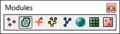
File:WMSmodulebar.png The Module palette in WMS. For the non-palette version, see [[:File:Module toolbar in WMS.png]]. [[Category:Toolbar icons]](200 × 57 (5 KB)) - 17:02, 2 March 2018
File:SMS Select Cell Cell Tool.svg SMS CGrid Select Cell Tool Icon in the Cartesian Grid module. [[Category:2D Grid Icons]](60 × 70 (8 KB)) - 14:49, 27 June 2017
File:WMS CreateGagesTool.svg [[Category:2D Grid Icons]] [[Category:WMS 2D Grid Module Tool Icons]](60 × 60 (5 KB)) - 17:00, 18 January 2018
File:Hydrologic Inactive Icon.svg [[Category:Project Explorer Icons]] [[Category:Hydrologic Module Icons]](56 × 60 (9 KB)) - 14:47, 28 May 2019
File:WMSIcon Create Gages.png [[Category:2D Grid Icons]] [[Category:WMS 2D Grid Module Tool Icons]](16 × 16 (601 bytes)) - 16:24, 19 January 2018
File:Tool ContourLabels.png [[Category:TIN Module Icons]](16 × 16 (278 bytes)) - 16:43, 3 March 2017
File:DEM Data icon in Project Explorer.png DEM Data icon used in the Project Explorer in WMS. It is part of the Terrain module. [[Category:Project Explorer Icons]](15 × 15 (305 bytes)) - 14:22, 15 August 2016
File:Module toolbar in WMS.png The Module toolbar in WMS. For the palette version, see [[:File:WMSmodulebar.jpg]]. [[Category:Toolbar icons]](185 × 24 (3 KB)) - 19:22, 2 March 2018
File:Set Contour Min Max tool in WMS.png [[Category:WMS Terrain Module Tool Icons]](16 × 16 (675 bytes)) - 15:07, 23 January 2018
File:Scale Bar Annotation Tool.svg [[Category:Annotation Icons]] The Create Scale Bar tool icon for the Annotations module in SMS(60 × 41 (4 KB)) - 14:22, 29 August 2017
File:Text Annotation Tool.svg [[Category:Annotation Icons]] The Create Text Object tool icon for the Annotations module in SMS(46 × 51 (3 KB)) - 14:22, 19 September 2017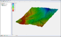
File:Raster4.png [[Category:Changing Icons]] Raster Module Example(800 × 486 (172 KB)) - 16:55, 27 July 2017
File:North Arrow Annotation Tool.svg [[Category:Annotation Icons]] The Create Annotation North Arrow tool icon for the Annotations module(52 × 52 (3 KB)) - 14:20, 29 August 2017
File:Module toolbar.png Example of the Module toolbar. [[Category:Toolbar icons]](280 × 27 (6 KB)) - 15:24, 28 July 2017
File:Create Cartesian Grid Tool.svg The Create Cartesian Grid tool in the Cartesian Grid module in SMS [[Category:2D Grid Icons]](60 × 60 (5 KB)) - 14:50, 20 June 2017
File:Object Annotation Tool.svg [[Category:Annotation Icons]] The Add Annotation Image tool icon for the Annotations module in SMS(60 × 45 (5 KB)) - 14:21, 29 August 2017
File:WMS FlowPathTool.svg [[Category:WMS Drainage Module Tool Icons]](30 × 45 (3 KB)) - 23:27, 17 January 2018
File:WMSIcon Move Basin Labels.png [[Category:WMS Drainage Module Tool Icons]](16 × 16 (767 bytes)) - 16:24, 19 January 2018
File:WMSIcon Flow Path.png [[Category:WMS Drainage Module Tool Icons]](10 × 16 (469 bytes)) - 16:24, 19 January 2018
File:Create Groin Tool.svg 1D Grid Module Create Jetty/Groin tool [[Category:1D Grid icons]](60 × 60 (3 KB)) - 14:21, 11 September 2017
File:WMS SelectDrainageUnitTool.svg [[Category:WMS Drainage Module Tool Icons]](60 × 66 (7 KB)) - 23:26, 17 January 2018
File:WMS MoveBasinLabels.svg [[Category:WMS Drainage Module Tool Icons]](60 × 64 (7 KB)) - 23:27, 17 January 2018
File:WMSIcon Select Drainage Unit.png [[Category:WMS Drainage Module Tool Icons]](16 × 16 (830 bytes)) - 16:25, 19 January 2018
File:Create Outlet Point tool in WMS.png [[Category:WMS Drainage Module Tool Icons]](16 × 16 (554 bytes)) - 16:24, 19 January 2018
File:Create Breakwater Tool.svg 1D Grid Module Create Breakwater Tool [[Category:1D Grid icons]](60 × 60 (3 KB)) - 14:20, 11 September 2017
File:Create Seawall Tool.svg 1D Grid Module Create Seawall tool [[Category:1D Grid icons]](60 × 60 (4 KB)) - 14:21, 11 September 2017
File:DEM Data Icon.svg DEM Data icon used in the Project Explorer in WMS. It is part of the Terrain module. [[Category:Project Explorer Icons]](53 × 53 (11 KB)) - 15:48, 1 June 2017
File:Create Borehole Tool.svg [[Category:Borehole Icons]] ...ol. This is not the same as Icon_BH.png which is the icon for the Borehole module.(22 × 60 (5 KB)) - 14:43, 21 August 2017
File:WMS SetContourMinMaxIcon.svg [[Category:WMS Terrain Module Tool Icons]](52 × 52 (150 KB)) - 19:59, 22 January 2018
File:WMS CreateOutletPointTool.svg [[Category:WMS Drainage Module Tool Icons]](45 × 45 (4 KB)) - 23:27, 17 January 2018


