Search results
From XMS Wiki
Jump to navigationJump to search
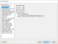
File:HydrologicModelingWizardWatershedData.png The watershed data step HY8 Modeling Wizard showing the Watershed Data step.(667 × 508 (52 KB)) - 20:52, 5 January 2024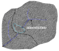
File:TriangulatedDrainageCoverage.png ...watershed delineation. However, when triangulating a set of scattered xyz data, it is difficult if not impossible to ensure that triangle edges conform to(329 × 285 (18 KB)) - 14:19, 3 May 2016
File:GSDA EPA Soil Type.png [[Category:GSDA Importing Data]] EPA soil type for an EPA watershed near Provo, Utah.(400 × 152 (70 KB)) - 14:32, 1 November 2017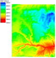
File:WMS DEMexampleQuick.jpg ...a resolution of 30-meters for the entire U.S. and some 90-meter world-wide data is also available.(443 × 459 (45 KB)) - 16:56, 5 January 2017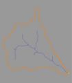
File:Fobj.jpg ...imes the simplest solution to creating a watershed model is to use the GIS data directly to delineate boundaries.(350 × 400 (8 KB)) - 16:22, 9 January 2017
File:Demtofobj.jpg ...(outlets), lines (streams), and polygons (boundaries) for more convenient data storage and manipulation.(350 × 400 (56 KB)) - 15:39, 9 January 2017


