Template:Raster Display Options
From XMS Wiki
Revision as of 20:16, 24 May 2022 by Jcreer (talk | contribs) (Created page with "==Raster Display Options== thumb|350 px|Example of the ''Raster Display Options'' dialog The ''Raster Display Options'' dialog is used to cha...")
Raster Display Options
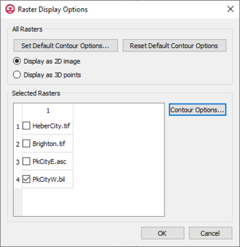
The Raster Display Options dialog is used to change the way rasters are displayed. This dialog is accessed by right-clicking on a raster file in the Project Explorer and selecting the Display Options command.
DEMs are imported and displayed as either 2D images or as a 3D point cloud.
The Raster Display Options dialog has the following options:
- Set Default Contour Options – This button will open a Contour Options dialog that will set contour options for all raster files in the project. Clicking the Color Ramp button in the Contour Options dialog will open the Color dialog. When accessing the Color dialog through this process, the differnet shader options are available.
- Reset Default Contour Options – Clicking this will restore the contour options to the default options/factory condition.
- Display as 2D Image – If displaying as a 2D image, the raster is only visible in plan view (like other images). This option is fast and memory efficient and can support large rasters (or several rasters). Hill shading, which enables shadows and thus makes the image appear 3D, is available in this mode.
- Display as 3D Points – If displaying as 3D points, the raster is visible in any view, not just plan view. 3D points are also very memory efficient but may be a little slower than the 2D image option. Also, hill shading is not available in this mode. The point size and the maximum number of points to display can be specified. Specifying a maximum number of points can be useful if the size of the raster is such that rendering becomes slow.
- Selected Rasters – This list will show all rasters that have been imported into the project.
- Contour Options – This button will open a Contour Options dialog that will set contour options for the selected raster files in the project. Clicking the Color Ramp button in the Contour Options dialog will open the Color dialog. When accessing the Color dialog through this process, the differnet shader options are available.
Shaders
With either 2D or 3D, four different shaders, which control the color ramp, are available. A color legend can be displayed to relate colors with values. To view shading, use the Lighting display options.
