File:Concmod.png
From XMS Wiki
Jump to navigationJump to search

No higher resolution available.
Concmod.png (436 × 304 pixels, file size: 3 KB, MIME type: image/png)
The first step in creating a conceptual model of this site is to create points, arcs and polygons that represent hydrologic features at the site. These points, arcs and polygons are assigned types that correspond to the feature they represent. Based on the attribute type, parameters such as head, concentration and conductance are assigned to these feature objects.
File history
Click on a date/time to view the file as it appeared at that time.
| Date/Time | Thumbnail | Dimensions | User | Comment | |
|---|---|---|---|---|---|
| current | ★ Approved revision 14:46, 21 April 2016 | | 436 × 304 (3 KB) | Jcreer (talk | contribs) | |
| 17:16, 10 May 2007 | 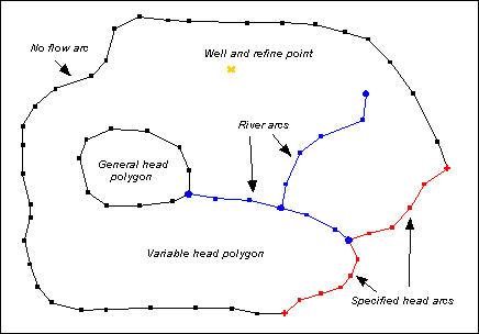 | 436 × 304 (4 KB) | Cballard (talk | contribs) |
You cannot overwrite this file.
File usage
The following page uses this file: