File:DEM FlowDirection.png
From XMS Wiki
Jump to navigationJump to search

No higher resolution available.
DEM_FlowDirection.png (208 × 188 pixels, file size: 1 KB, MIME type: image/png)
Figure 1: Flow directions are computed by determining which of the eight neighboring DEM points has the lowest elevation
File history
Click on a date/time to view the file as it appeared at that time.
| Date/Time | Thumbnail | Dimensions | User | Comment | |
|---|---|---|---|---|---|
| current | ★ Approved revision 16:00, 9 June 2016 | | 208 × 188 (1 KB) | Jcreer (talk | contribs) | |
| 17:04, 12 June 2007 | 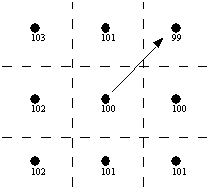 | 208 × 188 (3 KB) | Cballard (talk | contribs) |
You cannot overwrite this file.
File usage
The following page uses this file: