User:Cmadsen: Difference between revisions
From XMS Wiki
Jump to navigationJump to search
No edit summary |
No edit summary |
||
| Line 15: | Line 15: | ||
==User Gage Weighting== | |||
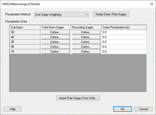
[[File:HMS Gages1.png|thumb|none|left|500 px|''HMS Meteorological Model'' dialog for the "User Gage Weighting" method.]] | |||
[[WMS:HEC-HMS Gages|''User Gage Weighting'' dialog]] | |||
==Manage Cross Sections Dialog== | |||
*''Cross Section Database'' | |||
**Select cross section database from drop-down menu | |||
**'''New Database''' – Allows for creation of new cross section database to be defined. | |||
**'''Delete Database''' – Deletes database. | |||
**File type to import | |||
***'''CSDB file (*.wms; *.sms; *.h5; *.idx)''' – File type to import. | |||
***'''HEC-RAS / HEC-2 (*.g*; *.dat)''' – File type to import. | |||
**'''Import...''' – Brings up ''Open'' dialog to find file to import. | |||
**'''Export...''' – Brings up ''Select a database name'' dialog to save the exported cross section database. | |||
**'''Database→Cov''' – Creates a new coverage based on the cross section database selected. | |||
**'''Cov→LnProps''' – Extracts line properties from the cross section coverage. | |||
**'''Database→DTM''' – Creates a digital terrain model from the cross section geometry | |||
**'''Topo ID''' – a topographic identifier and description that identifies where the cross section database was derived from. Create a new Topo ID for each database. | |||
**'''Line Prop Types''' – Opens the ''Line Property Types'' dialog that allows editing and assigning different data types to the line. | |||
**'''PT Prop Types''' – Opens the ''Point Property Types'' dialog that allows inclusion or exclusion of any or all of the left bank, right bank, and thalweg of the cross section. | |||
*''Cross Section'' | |||
**''Number of Cross Sections'' – Shows the number of cross sections in the database. | |||
**The table contains the Reach Name, the Station location, and the Assignment (or Cross Section database arc ID). | |||
**'''New''' – Create a new cross section. | |||
**'''Edit''' – Opens the ''Cross-Section Attributes'' dialog where cross section properties may be edited. | |||
**'''Copy''' – Copies a selected cross section. | |||
**'''Delete''' – Deletes the selected cross section. | |||
**The graph shows the left bank, right bank, and thalweg elevations for a selected cross section in the table. | |||
Revision as of 18:24, 12 September 2024
Clorinda Madsen
- Aquaveo
User:Cmadsen/GSSHA_Simulation_Workflow
Snap Outlet Points to Streams Tool
This is an edit
User Gage Weighting
Manage Cross Sections Dialog
- Cross Section Database
- Select cross section database from drop-down menu
- New Database – Allows for creation of new cross section database to be defined.
- Delete Database – Deletes database.
- File type to import
- CSDB file (*.wms; *.sms; *.h5; *.idx) – File type to import.
- HEC-RAS / HEC-2 (*.g*; *.dat) – File type to import.
- Import... – Brings up Open dialog to find file to import.
- Export... – Brings up Select a database name dialog to save the exported cross section database.
- Database→Cov – Creates a new coverage based on the cross section database selected.
- Cov→LnProps – Extracts line properties from the cross section coverage.
- Database→DTM – Creates a digital terrain model from the cross section geometry
- Topo ID – a topographic identifier and description that identifies where the cross section database was derived from. Create a new Topo ID for each database.
- Line Prop Types – Opens the Line Property Types dialog that allows editing and assigning different data types to the line.
- PT Prop Types – Opens the Point Property Types dialog that allows inclusion or exclusion of any or all of the left bank, right bank, and thalweg of the cross section.
- Cross Section
- Number of Cross Sections – Shows the number of cross sections in the database.
- The table contains the Reach Name, the Station location, and the Assignment (or Cross Section database arc ID).
- New – Create a new cross section.
- Edit – Opens the Cross-Section Attributes dialog where cross section properties may be edited.
- Copy – Copies a selected cross section.
- Delete – Deletes the selected cross section.
- The graph shows the left bank, right bank, and thalweg elevations for a selected cross section in the table.
