User:Kczappa
Kayla Czappa
- Aquaveo
Links to remember to edit: https://www.xmswiki.com/index.php?title=WMS:TR-20_Reservoir_Data&action=submit
https://www.xmswiki.com/wiki/WMS:TR-20_Routing_Data#Defined_Cross_Sections
Pages On WMS that needs to be done:
Edit HEC-1 Parameters Dialog which include:
Basin HEC-1 Cards dialogs that include:
Basin Data... Output Control... Precipitation... Loss Method... Unit Hydrograph Method... Snow Melt Data...
Routing HEC-1 Cards dialogs include:
Routing Data... Output Control... Reservoir Data... Channel Data... Output Control...
HEC-1 File Output (select to edit)
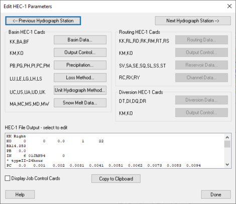
WMS: Edit HEC-1 Parameters dialog
When a basin is selected in the HEC-1 model, selecting HEC-1 | Edit Parameters will bring up the Edit HEC-1 Parameters dialog with the Basin HEC-1 Cards section active. The following can then be specified:
<--Previous Hydrograph Station –
Next Hydrograph Station--> –
Basin HEC-1 Cards section –
- Basin Data... – Allows the specification of Basin Data.
- KK – Basin Name.
- BA – Basin Area.
- BF – Baseflow.
- Output Control... – Allows different output controls to be specified.
- KM – Comment Lines.
- KO – Output Control.
- Precipitation... – Allows the specification of precipitation data.
- PB – Basin Average Precipitation.
- PG – Precipitation Gage.
- PH – Hypothetical Storm.
- PI – Probable Maximum Precipitation.
- PC –
- PM –
- Loss Method... – Allows the specification of Loss Methods being applied.
- LU – Uniform Loss Method.
- LE – Exponential Loss
- LG – Green & Ampt.
- LH – Holtan.
- LS – SCS Loss Method.
- Unit Hydrograph Method... – Allows the specification of Hydrograph methods being applied.
- UC – Clark Unit Hydrograph.
- US – Snyder
- UA –
- UD – SCS Dimensionless.
- UK – Kinematic Wave.
- Snow Melt Data... – Allows the specification of snow melt data.
- MA – Elevation Zone Data.
- MC –
- MS – Shot-Wave Radiation Time Series.
- MD – Dew Point Time Series.
- MW – Wind Speed Time Series.
Routing HEC-1 Cards section –
- Routing Data... – Allows the specification of routing data.
- KK – Outlet Names.
- RL – Channel Losses.
- RD – Muskingum-Cunge.
- RK – Kinematic Wave.
- RM – Muskingum.
- RT – Straddler Stagger.
- RS – Storage Routing.
- Output Control... – Allows different output controls to be specified.
- KM – Comment Lines.
- KO – Output Control.
- Reservoir Data... – Allows the specification of reservoir data.
- SV – Volume.
- SA – Area.
- SE – Elevation.
- SQ – Outflow.
- SL – Low-Level Outlet.
- SS – Spillway Characteristics.
- ST – Dam Overtopping.
- Channel Data... – Allows the specification of Channel data.
- AC –
- RX –
- RY –
Diversion HEC-1 Cards section –
- Diversion Data... – Allows the specification of diversion data.
- DT – Editing Diversion Data.
- DI – Inflow.
- DQ – Outflow.
- DR –
- Output Control... – Allows different output controls to be specified.
- KM – Comment Lines.
- KO – Output Control.
HEC-1 File Output-select to edit section –
"Display Job Control Cards" – By selecting this, it allows the Job Controls to be viewed.
Copy to Clipboard – Allows the information to be copied to the clipboard for any future use.
Help –
Channel Data Dialog
RK/RD Channels Dialog
Accessed by selecting Define Channels in the Kinematic wave section of the HEC-1 Unit Hydrograph Methods dialog. Main Channel RK/RD record
- Normal Muskingum Cunge Parameters
- L – Channel length.
- S – Channel slope.
- N – Manning's roughness.
- Shape – Characteristic channel shape.
- TRAP – Trapezoid.
- DEEP – Deep.
- CIRCULAR – Circular.
- WD – Base width of the channel.
- Z – Side slope of channel.
- Use Cross Section – Select to bring up the Define Cross Section option in this dialog.
- Define Cross Section – Select to bring up the XY Series Editor dialog.
Second RK/RD record (HMS collector) – Select to enter a second RK/RD record.
- L – Channel length.
- S – Channel slope.
- N – Manning's roughness.
- Shape – Characteristic channel shape.
- TRAP – Trapezoid.
- DEEP – Deep.
- CIRCULAR – Circular
- WD – Base width of the channel.
- Z – Side slope of channel.
Third RK/RD record (HMS collector) – Select to enter a third RK/RD record.
- L – Channel length.
- S – Channel slope.
- N – Manning's roughness.
- Shape – Characteristic channel shape.
- TRAP – Trapezoid.
- DEEP – Deep.
- CIRCULAR – Circular.
- WD – Base width of the channel.
- Z – Side slope of channel.
Route upstream hydrographs to main channel – Select to route upstream hydrographs to the main channel.
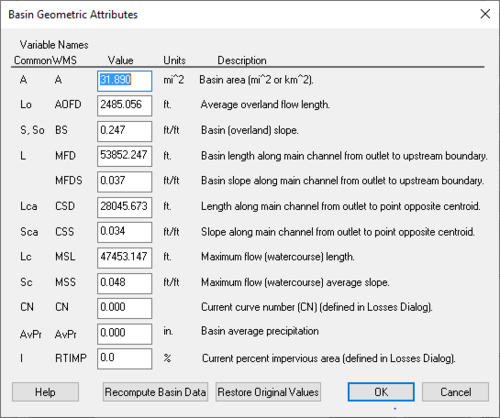
WMS:Basin Geometric Attributes Dialog
Accessed by selecting Basin Geometrical Attributes located in the HEC-1 Unit Hydrograph Methods dialog. Variable Names – Below the Variable Names heading is a table that allows the inputting of values for each one of the listed variables' names.
Recompute Basin Data – Select to bring up the Units dialog.
Restore Original Values – Select to revert all values in the Variable Names table back to their original values.
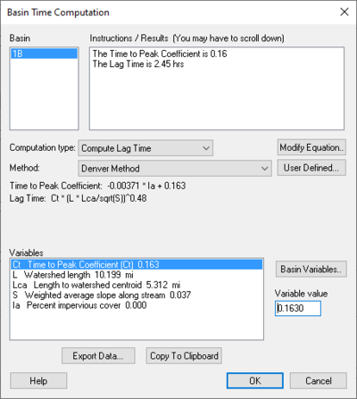
Basin Time Computation Dialog
Accessed by selecting Compute Parameters-Basin Data in the HEC-1 Unit Hydrograph Methods dialog. Basin – Instructions / Results (You may have to scroll down) – Computational type: –
| Selections | Selection Options | ||
|---|---|---|---|
| Method: | "Denver Method"
"Tulsa Rural Method" – "Tulsa 50% Urban Method" – "Tulsa 100% Urban Method" – "Espey Rural Method" – "Espey No Urbanization Method" – "Espey Partly Urban Method" – "Espey Completely Urban Method" – "Riverside Mountains Method" – "Riverside Foothills Method" – "Eagleson Method" – "USGS Nationwide Urban Method" – "Putnam Method" – "Taylor Method" – "Colorado State University (CSU) Method" – "Scs Method" – "Custom Method" – | ||
| User Defined... – | Select to bring up Modify Equation dialog. | ||
| Modify Equation... | Select to bring up the Modify Equation dialog that allows you to modify the equation used for the Basin time computation. | ||
| Basin Variables... – |
| Selections | Selection Options | ||
|---|---|---|---|
| Method: | "User Defined Method"
"Kirpich Method for overland flow on bare earth" – "Kirpich Method for overland flow on grassy earth" – "Kirpich Method for overland flow on asphalt" – "Kirpich Method for overland flow on bare earth (Mountains)" – "Kirpich Method for overland flow on grassy earth (Mountains)" – "Kirpich Method for overland flow on asphalt (Mountains)" – "Ramser Method for channel flow" – "Fort Bend County Method" – "Kerby Method for overland flow" – "ADOT Method (Desert/Mountain)" – "ADOT Method (Urban)" – | ||
| User Defined... – | Select to bring up Modify Equation dialog. | ||
| Modify Equation... | Select to bring up the Modify Equation dialog that allows you to modify the equation used for the Basin time computation. | ||
| Basin Variables... – |
- Instructions – Place that allows the reading of warnings that may occur in the equation as well as a list of pre-defined variables that are computed by WMS.
Equation – The equation being used for calculation.
- Parse – Click to parse through the equation.
Variable Abbreviations – A list of variable abbreviations relating to the equation. Definitions – A list of definitions for the variable abbreviations. Units – ||The units that apply to the definition chosen.
- "none"
- "ft" – Feet
- "m" – Meters
- "km" – Kilometers
- "mi" – Mile
- hr" – Hour
- "min" – Minute
- "sec" — Second
- "sq. mi" – Square mile (mi^2)
- "sq. km" – Square kilometer (km^2)
- "sq. ft" – Square foot (ft^2)
- "acre" –
- "hect" –
- "in" – Inch
- "mm" – Millimeter
- "ft/mi" – Foot per mile
- "fract" –
Method: –
Related links: https://www.xmswiki.com/wiki/WMS:Travel_Times_from_Basin_Data
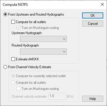
Compute NSTPS Dialog
Accessed by Selecting Compute NSTPS in the HEC-1 Routing Data dialog.
From Upstream and Routed Hydrographs – Select to allow the definition of variables associated with Upstream and Routed Hydrographs.
Compute for all outlets – Select to compute for all outlets.
- Turn on Muskingum routing – Select to apply Muskingum routing.
Upstream Hydrograph – Select to choose an Upstream Hydrograph.
Estimated AMSKK – Select to find the estimated Muskingum k coefficient in hours for entire reach.
For Channel Velocity Estimate – Select to find the estimate for the channel velocity.
Compute for currently selected outlet – Select to compute the outlet that has been chosen.
Compute for all outlets – Select to compute for all outlets.
- Turn on Muskingum routing – Select to apply Muskingum routing.
Channel Velocity Estimate: – An estimation of the channel velocity measured in feet per second.
Define Reservoir Data – Select to open Define Reservoir Data dialog.
Related Links:
https://www.xmswiki.com/wiki/WMS:TR-20_Reservoir_Data
Reservoir Output Control – Select to open Reservoir Output Control dialog.
Related Links:


