File:ArcGIS Pro Create Blnk AHGW Geodtabse.png
From XMS Wiki
Jump to navigationJump to search

Size of this preview: 217 × 599 pixels.
Original file (349 × 963 pixels, file size: 31 KB, MIME type: image/png)
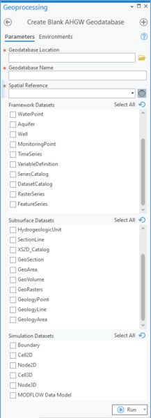
The Create Blank AHGW Geodatabase tool in the Geoprocessing pane in ArcGIS Pro.
File history
Click on a date/time to view the file as it appeared at that time.
| Date/Time | Thumbnail | Dimensions | User | Comment | |
|---|---|---|---|---|---|
| current | ★ Approved revision 20:19, 11 August 2022 | 349 × 963 (31 KB) | Rcorrigan (talk | contribs) | ||
| 20:18, 11 August 2022 | 349 × 984 (36 KB) | Rcorrigan (talk | contribs) |
You cannot overwrite this file.
File usage
The following 2 pages use this file: