File:InterpolatingHydraulicModelResults1.png: Difference between revisions
From XMS Wiki
Jump to navigationJump to search
m (Jcreer moved page File:Image296.gif to File:InterpolatingHydraulicModelResults1.gif) |
(Jcreer uploaded a new version of File:InterpolatingHydraulicModelResults1.gif) |
(No difference)
| |
Revision as of 15:20, 3 May 2016
After running a 1D Hydraulic model like HEC-RAS, the result is a water surface elevation (or hydrograph for a dynamic solution) at the cross section as indicated by the red circles in the river section.
File history
Click on a date/time to view the file as it appeared at that time.
| Date/Time | Thumbnail | Dimensions | User | Comment | |
|---|---|---|---|---|---|
| current | ★ Approved revision 15:20, 3 May 2016 |  | 287 × 293 (4 KB) | Jcreer (talk | contribs) | |
| 20:12, 28 June 2007 | 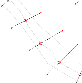 | 287 × 293 (4 KB) | Cballard (talk | contribs) |
You cannot overwrite this file.
File usage
The following 2 pages use this file: