Search results
From XMS Wiki
Jump to navigationJump to search
Page title matches
- #redirect [[Category:File Format]]24 members (3 subcategories, 9 files) - 17:03, 14 December 2016
- #REDIRECT [[GMS:File Import Wizard Supported File Formats]]59 bytes (8 words) - 18:34, 5 November 2013
- #REDIRECT [[GMS:File Formats]]30 bytes (4 words) - 17:25, 7 November 2013
- #REDIRECT [[GMS:File Import Wizard Supported File Formats]]59 bytes (8 words) - 18:32, 5 November 2013
- {{catmain|File Formats}} Articles related to file formats in XMS and all file formats which are common to [[GMS:GMS|GMS]], [[SMS:SMS|SMS]], and [[WMS:WMS23 members (3 subcategories, 9 files) - 15:50, 29 November 2017
- 30 bytes (5 words) - 15:33, 10 November 2015
- #REDIRECT [[GMS:File Import Wizard Supported File Formats]]59 bytes (8 words) - 18:34, 5 November 2013
- 35 bytes (5 words) - 16:51, 2 October 2013
- #REDIRECT [[GMS:File Import Wizard Supported File Formats]]59 bytes (8 words) - 18:34, 5 November 2013
- #REDIRECT [[GMS:File Import Wizard Supported File Formats]]59 bytes (8 words) - 18:32, 5 November 2013
- 29 bytes (4 words) - 14:45, 2 October 2013
- #redirect [[Raster File Formats]]33 bytes (4 words) - 19:50, 15 August 2019
- #redirect [[Category:WMS File Formats]]0 members (0 subcategories, 0 files) - 14:08, 18 July 2016
- #REDIRECT [[WMS:WMS Supported File Formats]]44 bytes (6 words) - 17:45, 1 October 2013
- #REDIRECT [[GMS:File Import Wizard Supported File Formats]]59 bytes (8 words) - 18:32, 5 November 2013
- ...he locations of these vertices must be specified in the grid specification file, together with the node that is associated with a model cell. The format is defined in <!--[http://www.pesthomepage.org/getfiles.php?file=gwutil_a.pdf the Groundwater Data Utilities article] and repeated in--> the935 bytes (136 words) - 15:08, 21 April 2022
- #REDIRECT [[WMS:WMS Supported File Formats]]44 bytes (6 words) - 17:45, 1 October 2013
- 38 bytes (5 words) - 15:54, 10 February 2014
- 38 bytes (5 words) - 16:49, 10 February 2014
- 23 bytes (3 words) - 14:58, 7 October 2013
Page text matches
File:Lidar load Options.png [[Category:File Format]] [[Category:SMS File Format Dialogs]](712 × 569 (33 KB)) - 22:28, 29 November 2022
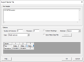
File:File Import Wizard - Step 2 of 2.png [[Category:SMS File Format Dialogs]] Step 2 of the Text Import Wizard – File format(644 × 412 (22 KB)) - 19:43, 6 June 2023- XMS software can handle a wide range of file formats. !File Format495 bytes (79 words) - 18:51, 29 June 2018
- ...s a means of transferring data to and from SMS. It is a simple ASCII file format that defines the type of data and its time reference. ===Sample Format===2 KB (146 words) - 17:47, 16 December 2014
- ...en imported into WMS using the '''Open''' command in the [[WMS:File Menu|''File'' menu]]. ...are self explanatory. The GSSHA model also uses the GRASS ASCII grid file format for all of the map parameters.1 KB (214 words) - 21:32, 24 April 2019
File:WMS Import ArcInfo Grid.jpg [[Category:SMS File Format Dialogs]] [[Category:SMS File Formats]](442 × 547 (40 KB)) - 15:12, 5 January 2016- ...r|Project Explorer]] and selecting the '''Export''' command. The supported file formats are: ! Format !! Description1 KB (169 words) - 15:30, 29 November 2017
- == File Overview == ...are usually time-varying. The wave input file can be in ASCII or [[XMDF]] format.1 KB (168 words) - 16:12, 6 December 2017
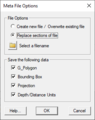
File:MetaFileOptions.png Meta File Options dialog [[Category:SMS File Format Dialogs]](257 × 325 (9 KB)) - 20:59, 30 July 2020- File formats for GMS. [[Category:File Format]]7 members (0 subcategories, 1 file) - 15:06, 19 May 2017
- ...d. These contain a 2D scatter point file and the corresponding ASCII data file. ...in several files without having to identify each file individually in the file browser.2 KB (319 words) - 16:22, 26 September 2017
- The ''Export UGrid'' tool exports the grid to a file; the file format is chosen as part of the tool inputs. *''File type'' – Select the desired output format.1 KB (182 words) - 18:51, 30 October 2023
- #redirect [[Category:File Format]]24 members (3 subcategories, 9 files) - 17:03, 14 December 2016
File:ExportTabularFile.png SMS Export Tabular File dialog. [[Category:SMS File Format Dialogs]](632 × 471 (13 KB)) - 20:57, 30 July 2020- #redirect [[GMS:GSF File Format]]33 bytes (5 words) - 21:20, 28 October 2016
- #redirect [[GMS:GSF File Format]]33 bytes (5 words) - 21:20, 28 October 2016
- #redirect [[GMS:GSF File Format]]33 bytes (5 words) - 21:20, 28 October 2016
- #redirect [[GMS:GSF File Format]]33 bytes (5 words) - 21:22, 28 October 2016
- #redirect [[GMS:GSF File Format]]33 bytes (5 words) - 21:22, 28 October 2016
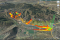
File:GoogleEarthKmzAnimExport.png [[Category:File Format]] KMZ file exported from WMS and opened in Google Earth(1,428 × 950 (1.87 MB)) - 14:45, 25 May 2018


