File:WMS MapProjectExplorer2.png
From XMS Wiki
Jump to navigationJump to search
No higher resolution available.
WMS_MapProjectExplorer2.png (230 × 91 pixels, file size: 4 KB, MIME type: image/png)
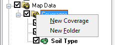
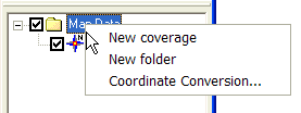
Right-clicking on the Map Data folder allows users to create a New coverage or New folder to organize coverages in, or perform Coordinate Conversions on all of the coverages.
File history
Click on a date/time to view the file as it appeared at that time.
| Date/Time | Thumbnail | Dimensions | User | Comment | |
|---|---|---|---|---|---|
| current | ★ Approved revision 17:21, 9 March 2018 | 230 × 91 (4 KB) | Jcreer (talk | contribs) | ||
| 14:43, 19 October 2015 | 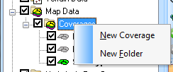 | 244 × 102 (5 KB) | Jcreer (talk | contribs) | ||
| 16:49, 7 August 2007 | 277 × 104 (4 KB) | Eshaw (talk | contribs) |
You cannot overwrite this file.
File usage
The following 2 pages use this file: