|
|
| (4 intermediate revisions by the same user not shown) |
| Line 1: |
Line 1: |
| {{TOC bottom}} | | {{TOC bottom}} |
| {{HGS Links}} | | {{HGS Links}} |
| The ''Arc Properties'' dialog is where the parameters for an arc in a boundary conditions or hydrograph coverage are defined in a HydroGeoSphere model. Only one type of boundary condition can be assigned to a feature object on a boundary conditions coverage. For hydrograph coverages, "Hydrograph" is the only option available to assign to a feature object. | | The ''Arc Properties'' dialog is where the parameters for an arc in a [[GMS:HydroGeoSphere Coverages|boundary conditions coverage]] or [[GMS:HydroGeoSphere Coverages|hydrograph coverage]] are defined in a HydroGeoSphere model. Only one type of boundary condition can be assigned to a feature object on a boundary conditions coverage. For hydrograph coverages, "Hydrograph" is the only option available to assign to a feature object. |
| [[File:HGS arc prop.png|thumb|450 px|''Arc Properties'' dialog for the boundary conditions coverage]] | | [[File:HGS arc prop.png|thumb|450 px|''Arc Properties'' dialog for the boundary conditions coverage]] |
|
| |
|
| Line 25: |
Line 25: |
| ***** ''Interpolate'' – Causes time-varying values to be interpolated, resulting in a smoother application of the time-varying function. | | ***** ''Interpolate'' – Causes time-varying values to be interpolated, resulting in a smoother application of the time-varying function. |
| ***** ''Map to grid boundary'' – Map boundary condition to the boundary of the grid (not the interior). | | ***** ''Map to grid boundary'' – Map boundary condition to the boundary of the grid (not the interior). |
| | **** Note – If different values are specified for the start and end, then the values are interpolated to the points in the middle of the arc using linear interpolation. |
| **"Surface flow" – Set properties for surface flow. | | **"Surface flow" – Set properties for surface flow. |
| *** ''Input type'' – How the boundary condition data is specified. | | *** ''Input type'' – How the boundary condition data is specified. |
| Line 36: |
Line 37: |
| ***** ''Interpolate'' – Causes time-varying values to be interpolated, resulting in a smoother application of the time-varying function. | | ***** ''Interpolate'' – Causes time-varying values to be interpolated, resulting in a smoother application of the time-varying function. |
| ***** ''Map to grid boundary'' – Map boundary condition to the boundary of the grid (not the interior). | | ***** ''Map to grid boundary'' – Map boundary condition to the boundary of the grid (not the interior). |
| | **** Note – If different values are specified for the start and end, then the values are interpolated to the points in the middle of the arc using linear interpolation. |
|
| |
|
| ==Simple River or Simple Drain== | | ==Simple River or Simple Drain== |
| Line 53: |
Line 55: |
| ==Critical Depth== | | ==Critical Depth== |
| The critical depth boundary condition determines the rate at which mass is leaving the model domain. | | The critical depth boundary condition determines the rate at which mass is leaving the model domain. |
| * ''Name'' | | * ''Name'' – A descriptive name for the boundary condition, which can be up to 80 characters. |
| <!--* ''Transient'' – Define a time value table to turn the boundary condition on and off. Values of -99999 indicate that the BC is turned off. | | <!--* ''Transient'' – Define a time value table to turn the boundary condition on and off. Values of -99999 indicate that the BC is turned off. |
| ** ''Time series'' – Time value table. Values of -99999 indicate that the BC is turned off.--> | | ** ''Time series'' – Time value table. Values of -99999 indicate that the BC is turned off.--> |
The Arc Properties dialog is where the parameters for an arc in a boundary conditions coverage or hydrograph coverage are defined in a HydroGeoSphere model. Only one type of boundary condition can be assigned to a feature object on a boundary conditions coverage. For hydrograph coverages, "Hydrograph" is the only option available to assign to a feature object.
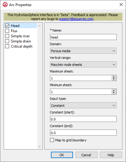
Arc Properties dialog for the boundary conditions coverage
Head or Flux
Head and flux are two separate available arc property types on a boundary conditions coverage, but the input options available are the same. Head is a general specified head boundary condition, and flux is a general specified flux boundary condition. The input options for head and flux are listed below.
- Name – Enter a name for the arc.
- Domain – The domain in which the boundary condition is applied.
- "Porous media" – Set properties for porous media.
- Vertical range – Vertical range for porous media.
- "Max/min node sheets" – Boundary conditions will be applied between the minimum and maximum node sheets.
- Maximum sheet – Value for the maximum node sheets.
- Minimum sheet – Value for the minimum node sheets.
- "Top/bottom elevations" – Boundary conditions will be applied between the top and bottom elevations.
- Top elevation – Value for the top elevation.
- Bottom elevation – Value for the bottom elevation.
- Input type – How the boundary condition data is specified.
- "Constant"
- Constant (start) – Constant value of the boundary condition at the start of the arc.
- Constant (end) – Constant value of the boundary condition at the end of the arc.
- "Time series"
- Time series (start) – Time-varying values of the boundary condition at the start of the arc.
- Time series (end) – Time-varying values of the boundary condition at the end of the arc.
- Interpolate – Causes time-varying values to be interpolated, resulting in a smoother application of the time-varying function.
- Map to grid boundary – Map boundary condition to the boundary of the grid (not the interior).
- Note – If different values are specified for the start and end, then the values are interpolated to the points in the middle of the arc using linear interpolation.
- "Surface flow" – Set properties for surface flow.
- Input type – How the boundary condition data is specified.
- "Constant"
- Constant (start) – Constant value of the boundary condition at the start of the arc.
- Constant (end) – Constant value of the boundary condition at the end of the arc.
- Map to grid boundary – Map boundary condition to the boundary of the grid (not the interior).
- "Time series"
- Time series (start) – Time-varying values of the boundary condition at the start of the arc.
- Time series (end) – Time-varying values of the boundary condition at the end of the arc.
- Interpolate – Causes time-varying values to be interpolated, resulting in a smoother application of the time-varying function.
- Map to grid boundary – Map boundary condition to the boundary of the grid (not the interior).
- Note – If different values are specified for the start and end, then the values are interpolated to the points in the middle of the arc using linear interpolation.
Simple River or Simple Drain
Simple river and simple drain are two separate available arc property types on a boundary conditions coverage, but the input options available are the same. Simple river is a river flux drainage boundary condition, and simple drain is a drain flux drainage boundary condition. The input options for simple river and simple drain are listed below.
- Name – Enter a name for the arc.
- Input type – How the boundary condition data is specified.
- "Constant"
- Constant (start) – Constant value of the boundary condition at the start of the arc.
- Constant (end) – Constant value of the boundary condition at the end of the arc.
- Map to grid boundary – Map boundary condition to the boundary of the grid (not the interior).
- "Time series"
- Time series (start) – Time-varying values of the boundary condition at the start of the arc.
- Time series (end) – Time-varying values of the boundary condition at the end of the arc.
- Interpolate – Causes time-varying values to be interpolated, resulting in a smoother application of the time-varying function.
- Map to grid boundary – Map boundary condition to the boundary of the grid (not the interior).
Critical Depth
The critical depth boundary condition determines the rate at which mass is leaving the model domain.
- Name – A descriptive name for the boundary condition, which can be up to 80 characters.
- Map to grid boundary – Map boundary condition to the boundary of the grid (not the interior).
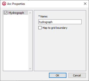
Arc Properties dialog for the Hydrograph coverage
Hydrograph
Assigning "hydrograph" to an arc causes HydroGeoSphere to record hydrograph data during the model run. The coverage then needs to be added to the simulation. Upon the completing the simulation run, HGS will output detailed flow rate information at each time step for each arc that has been assigned a hydrograph.
- Name – A descriptive name for the hydrograph, which can be up to 80 characters.
- Map to grid boundary – Map grid to the boundary of the grid, not the interior.
Related Topics

