|
|
| (5 intermediate revisions by the same user not shown) |
| Line 1: |
Line 1: |
| {{TOC bottom}} | | {{TOC bottom}} |
| {{HGS Links}} | | {{HGS Links}} |
| The ''Point Properties'' dialog in the HydroGeoSphere model is where the input parameters for nodes associated with the relative coverage are set. The boundary conditions, observations, and hydrograph coverages each have their own individual parameters under the ''Point Properties'' dialog, depending on which coverage is active. Only one type of boundary condition can be assigned to a feature object on a boundary conditions coverage. For hydrograph or observation coverages, "Hydrograph" or "Observation" is the only option available to assign to a feature object, relative to the coverage type.
| | In the HydroGeoSphere model, the ''Point Properties'' dialog is where users set node input parameters for the respective coverage. The boundary conditions, observations, and hydrograph coverages each have their own parameters under the ''Point Properties'' dialog, depending the active coverage. Only one type of boundary condition can be assigned to a feature object on a boundary conditions coverage. For hydrograph or observation coverages, "Hydrograph" or "Observation" is the only option available to assign to a feature object, based on the coverage type. |
| [[File:HGS point prop.png|thumb|350 px|''Point Properties'' dialog for the boundary conditions coverage]] | | [[File:HGS point prop.png|thumb|350 px|''Point Properties'' dialog for the boundary conditions coverage]] |
|
| |
|
| Line 13: |
Line 13: |
| *** ''Input type'' – How the boundary condition data is specified. | | *** ''Input type'' – How the boundary condition data is specified. |
| **** ''Time series'' – Time-varying values of the boundary condition. A table is generated using the ''XY Series Editor'' dialog that is opened by clicking the '''Edit XY Series''' button by either manually entering the data, or importing the data. | | **** ''Time series'' – Time-varying values of the boundary condition. A table is generated using the ''XY Series Editor'' dialog that is opened by clicking the '''Edit XY Series''' button by either manually entering the data, or importing the data. |
| | *** ''Vertical range'' – Vertical range for porous media. |
| | ****"Top/bottom elevations" – Boundary conditions will be applied between the top and bottom elevations. |
| | *****''Top elevation'' – Value for the top elevation. |
| | *****''Bottom elevation'' – Value for the bottom elevation. |
| ** ''Surface flow'' | | ** ''Surface flow'' |
| *** ''Input type'' – How the boundary condition data is specified. | | *** ''Input type'' – How the boundary condition data is specified. |
| Line 23: |
Line 27: |
|
| |
|
| ==Hydrograph== | | ==Hydrograph== |
| GMS allows recording of hydrograph data on a point from the HydroGeoSphere model run. This requires that "Hydrograph" is set as the parameter for a point on a HydroGeoSphere hydrograph coverage, which is done inside the ''Point Properties'' dialog. The coverage then needs to be added to the simulation. Upon the simulation run, GMS will output detailed flow rate information at each time step for each point that has been assigned a hydrograph. The only input available in the ''Point Properties'' dialog on a hydrograph coverage is a name. The name should be something descriptive, and less than 80 characters.
| | Assigning "hydrograph" to an arc causes HydroGeoSphere to record hydrograph data during the model run. The coverage then needs to be added to the simulation. Upon the completing the simulation run, HGS will output detailed flow rate information at each time step for each arc that has been assigned a hydrograph. |
| | * ''Name'' – A descriptive name for the hydrograph, which can be up to 80 characters. |
| [[File:HGS point prop obs.png|thumb|350px|''Point Properties'' dialog for the observation coverage]] | | [[File:HGS point prop obs.png|thumb|350px|''Point Properties'' dialog for the observation coverage]] |
|
| |
|
In the HydroGeoSphere model, the Point Properties dialog is where users set node input parameters for the respective coverage. The boundary conditions, observations, and hydrograph coverages each have their own parameters under the Point Properties dialog, depending the active coverage. Only one type of boundary condition can be assigned to a feature object on a boundary conditions coverage. For hydrograph or observation coverages, "Hydrograph" or "Observation" is the only option available to assign to a feature object, based on the coverage type.
Point Properties dialog for the boundary conditions coverage
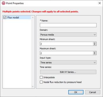
Flux Nodal
Flux nodal is a general specified flux boundary condition for a point on the boundary conditions coverage of a HydroGeoSphere model. The input options for a flux nodal designation are listed below.
- Name – The name of the boundary condition. Names should be unique and contain no white space.
- Domain – The domain in which the boundary conditions are applied.
- Porous media
- Minimum sheet – The minimum node sheet; boundary conditions are applied between the minimum and maximum node sheets.
- Maximum sheet – The maximum node sheet; boundary conditions are applied between the minimum and maximum node sheets.
- Input type – How the boundary condition data is specified.
- Time series – Time-varying values of the boundary condition. A table is generated using the XY Series Editor dialog that is opened by clicking the Edit XY Series button by either manually entering the data, or importing the data.
- Vertical range – Vertical range for porous media.
- "Top/bottom elevations" – Boundary conditions will be applied between the top and bottom elevations.
- Top elevation – Value for the top elevation.
- Bottom elevation – Value for the bottom elevation.
- Surface flow
- Input type – How the boundary condition data is specified.
- Constant – Constant value of the boundary condition.
- Time series – Time-varying values of the boundary condition. A table is generated using the XY Series Editor dialog that is opened by clicking the Edit XY Series button by either manually entering the data, or importing the data.
- Time raster table – The Edit Table... opens the Time raster table dialog where the data is entered by selecting a raster from outside GMS.
- Interpolate – Causes time-varying values to be interpolated, resulting in a smoother application of the time-varying function.
- Nodal flux reduction by pressure head – Reduces flux as a function of the nodal pressure head to avoid pumping from the dry materials.

Point Properties dialog for the hydrograph coverage
Hydrograph
Assigning "hydrograph" to an arc causes HydroGeoSphere to record hydrograph data during the model run. The coverage then needs to be added to the simulation. Upon the completing the simulation run, HGS will output detailed flow rate information at each time step for each arc that has been assigned a hydrograph.
- Name – A descriptive name for the hydrograph, which can be up to 80 characters.
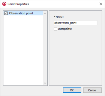
Point Properties dialog for the observation coverage
Observation
GMS allows recording of observation data from the HydroGeoSphere model run through observation points on a HydroGeoSphere observations coverage. When an observation point is created, GMS outputs timeseries information specific to the observation point during the simulation run. To create an observation point, select a point to designate as an observation point and set the parameters inside the Point Properties dialog. The input options for an observation point are listed below.
- Name – This should be a descriptive name for the observation point, and less than 40 characters.
- Interpolate – Output values are linearly interpolated from the nodal values at the vertices at the element that contains the observation point.
Related Topics


