SMS:ADH Extract WSE: Difference between revisions
From XMS Wiki
Jump to navigationJump to search
No edit summary |
|||
| Line 4: | Line 4: | ||
==Extract Boundary Condition Dialog== | ==Extract Boundary Condition Dialog== | ||
The dialog has the following options: | The dialog has the following options: | ||
*Regional model time options | *''Regional model time options'' – If extracting from a transient dataset, the time steps used can be set. | ||
**Start time | **''Start time'' – The first time step to use in the extraction. | ||
**End time | **''End time'' – The last time step to use in the extraction. | ||
*Boundary condition time options | *''Boundary condition time options'' | ||
** | **''Start time'' | ||
*Regional scalar model solution | *''Regional scalar model solution'' – In the tree, select the dataset to be used for extraction. | ||
==Related Topics== | ==Related Topics== | ||
Revision as of 15:30, 8 September 2016
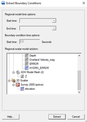
SMS now has the ability to extract water surface elevation to a nodestring boundary condition from an existing dataset. This is done by right-clicking on the nodestring and selecting Boundary Condition | Extract Water Surface Elevation... and selecting the dataset to extract from. SMS will break up the existing nodestring into segments and extract the water surface elevation at the midpoint of each segment. The nodestrings are then assigned the Tailwater (outflow) boundary condition and the extracted data is set as the time series. This data can be edited in the ADH Boundary Condition Assignment dialog.
Extract Boundary Condition Dialog
The dialog has the following options:
- Regional model time options – If extracting from a transient dataset, the time steps used can be set.
- Start time – The first time step to use in the extraction.
- End time – The last time step to use in the extraction.
- Boundary condition time options
- Start time
- Regional scalar model solution – In the tree, select the dataset to be used for extraction.
Related Topics
SMS – Surface-water Modeling System | ||
|---|---|---|
| Modules: | 1D Grid • Cartesian Grid • Curvilinear Grid • GIS • Map • Mesh • Particle • Quadtree • Raster • Scatter • UGrid |  |
| General Models: | 3D Structure • FVCOM • Generic • PTM | |
| Coastal Models: | ADCIRC • BOUSS-2D • CGWAVE • CMS-Flow • CMS-Wave • GenCade • STWAVE • WAM | |
| Riverine/Estuarine Models: | AdH • HEC-RAS • HYDRO AS-2D • RMA2 • RMA4 • SRH-2D • TUFLOW • TUFLOW FV | |
| Aquaveo • SMS Tutorials • SMS Workflows | ||
