GMS:HydroGeoSphere Renumber UGrid: Difference between revisions
From XMS Wiki
Jump to navigationJump to search
No edit summary |
No edit summary |
||
| (One intermediate revision by the same user not shown) | |||
| Line 1: | Line 1: | ||
{{Renumber UGrid}} | {{Renumber UGrid}} | ||
{{Navbox GMS}} | {{Navbox GMS}} | ||
[[Category:Toolbox]] | [[Category:Toolbox HGS]] | ||
[[Category:HydroGeoSphere]] | [[Category:HydroGeoSphere]] | ||
Latest revision as of 17:35, 23 February 2024
Renumber UGrid for HydroGeoSphere
The Renumber UGrid tool renumbers a 3D UGrid to meet HydroGeoSphere requirements.
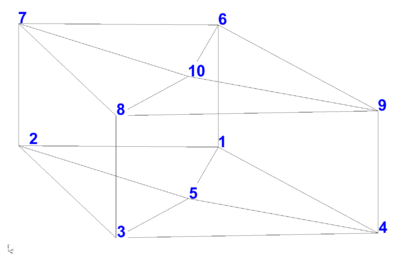
The 3D UGrid consists of a set of vertically offset node sheets, each of which is identical in 2D. Between consecutive node sheets is a layer of elements.
- The ordering of elements within each layer is identical, as is the ordering of nodes within each node sheet.
- Nodes are ordered from the bottom sheet (bottom of the domain) to the top sheet (top of the domain).
- Similarly, elements are ordered from the bottom layer (bottom of domain) to the top layer (top of domain).
- Any ordering of elements and nodes within a 2D layer or sheet is fine, so long as it is consistent among all layers and sheets.
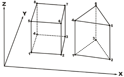
- Local node numbering per cell must follow the convention illustrated in Figure 2.
Input Parameters
- Input UGrid – The UGrid to be renumbered.
Output Parameters
- Output UGrid – The name of the UGrid that will be created.
Current Location in Toolbox
HydroGeoSphere | Renumber UGrid
GMS – Groundwater Modeling System | ||
|---|---|---|
| Modules: | 2D Grid • 2D Mesh • 2D Scatter Point • 3D Grid • 3D Mesh • 3D Scatter Point • Boreholes • GIS • Map • Solid • TINs • UGrids | |
| Models: | FEFLOW • FEMWATER • HydroGeoSphere • MODAEM • MODFLOW • MODPATH • mod-PATH3DU • MT3DMS • MT3D-USGS • PEST • PHT3D • RT3D • SEAM3D • SEAWAT • SEEP2D • T-PROGS • ZONEBUDGET | |
| Aquaveo | ||

