GMS:Active/Inactive Points: Difference between revisions
No edit summary |
|||
| Line 12: | Line 12: | ||
===Active/Inactive Flags Dialog=== | ===Active/Inactive Flags Dialog=== | ||
After a scatter point set has been imported to GMS, the active/inactive status flags for the active dataset can be edited by selecting the '''Edit Inactive Flags''' button in the [[GMS:Datasets#Dataset Info|''Dataset Info'']] dialog accessed from the ''Dataset Properties'' dialog (this dialog is accessed from the [[GMS:The GMS | After a scatter point set has been imported to GMS, the active/inactive status flags for the active dataset can be edited by selecting the '''Edit Inactive Flags''' button in the [[GMS:Datasets#Dataset Info|''Dataset Info'']] dialog accessed from the ''Dataset Properties'' dialog (this dialog is accessed from the [[GMS:The GMS Window|Project Explorer]]). This brings up the ''Active/Inactive Flags'' dialog. This dialog is used to either delete all of the current active/inactive flags (making all points active), or enter one or more key values (ex., -999) which are used to inactivate all points with the listed values. | ||
[[File:ActiveInactiveFlags.jpg|thumb|left|none|250 px|The ''Active/Inactive Flags'' dialog.]] | [[File:ActiveInactiveFlags.jpg|thumb|left|none|250 px|The ''Active/Inactive Flags'' dialog.]] | ||
Revision as of 14:51, 1 October 2014
Each scatter point has an active/inactive status. A scatter point with an inactive status can be displayed, but the dataset value at the point is ignored when interpolation takes place. As a result, interpolation proceeds as if the point did not exist.
The active/inactive flags for scatter points are particularly useful when dealing with transient data. For example, suppose that a set of scatter points represents TCE concentrations measured at a series of observation wells over a year's time. The locations of the wells and the measured concentrations can be imported to GMS as a scatter point set with a transient dataset. Once they are imported, the transient dataset can be interpolated to a grid and a film loop showing color shaded contours can be generated to illustrate how the plume has changed with time. However, in preparing the data for import, it is discovered that some of the data values are missing. One approach is to make up a dummy value for the missing sample and enter the entire dataset anyway. The problem with this approach is that it is difficult to determine an appropriate dummy value. Another option is to enter this value as a "non-detect". This causes the point to become inactive for the time step where the sample is missing. GMS disregards the point for that time step and performs the interpolation using the remaining active points.
Active/inactive flags are stored with datasets. If the active dataset is changed, the active/inactive flags will be reassigned based on the flags in the new active dataset. Not all datasets contain active/inactive flags. If a dataset does not contain flags, all points are assumed to be active.
The following methods can be used for controlling or assigning the active/inactive status of points:
Tabular Scatter Point Input
If the scatter points are imported using the File Import Wizard then a special data value can be designated as NONDETECT. This value is typically assigned to a number not likely to be encountered such as -999. Then, as the dataset columns are being read, any value with the NONDETECT value is assumed to be inactive and the status flag is set accordingly.
Active/Inactive Flags Dialog
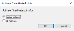
After a scatter point set has been imported to GMS, the active/inactive status flags for the active dataset can be edited by selecting the Edit Inactive Flags button in the Dataset Info dialog accessed from the Dataset Properties dialog (this dialog is accessed from the Project Explorer). This brings up the Active/Inactive Flags dialog. This dialog is used to either delete all of the current active/inactive flags (making all points active), or enter one or more key values (ex., -999) which are used to inactivate all points with the listed values.
GMS – Groundwater Modeling System | ||
|---|---|---|
| Modules: | 2D Grid • 2D Mesh • 2D Scatter Point • 3D Grid • 3D Mesh • 3D Scatter Point • Boreholes • GIS • Map • Solid • TINs • UGrids | |
| Models: | FEFLOW • FEMWATER • HydroGeoSphere • MODAEM • MODFLOW • MODPATH • mod-PATH3DU • MT3DMS • MT3D-USGS • PEST • PHT3D • RT3D • SEAM3D • SEAWAT • SEEP2D • T-PROGS • ZONEBUDGET | |
| Aquaveo | ||

