SMS:MapInfo MID/MIF: Difference between revisions
From XMS Wiki
Jump to navigationJump to search
(→Import) |
(→Import) |
||
| Line 18: | Line 18: | ||
* TUFLOW 2D/2D Linkage | * TUFLOW 2D/2D Linkage | ||
* TUFLOW Area Property | * TUFLOW Area Property | ||
* TUFLOW Boundary Conditions (flow over area) | |||
* TUFLOW Codes | * TUFLOW Codes | ||
* TUFLOW From Loss Coefficient | * TUFLOW From Loss Coefficient | ||
Revision as of 18:33, 8 July 2015
MapInfo Interchange Format is a map and database exporting file format of MapInfo software product. The MIF-file filename usually ends with .mif-suffix. Some MIF-files also have a related MID-file.
Export
To export maps in MIF/MID format:
- Load or create an existing map
- Select File | Save As
- Select Save as type:' and choose Catalog file (*.xml)
An XML file is created which outlines the directories of the MIF/MID files. A points.mif/mid, polygons.mif/mid and polylines.mif/mid (if exists) is also created.
Import
Using the File | Open menu command, open the saved XML file to import the mesh from a MIF/MID file.
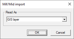
After selecting a MIF/MID file, the MIF/MID Import dialog will appear. Users have the option to import the MIF/MID file as one of the following options:
- GIS Layer
- TUFLOW 2D/2D Linkage
- TUFLOW Area Property
- TUFLOW Boundary Conditions (flow over area)
- TUFLOW Codes
- TUFLOW From Loss Coefficient
- TUFLOW Initial Water Level
- TUFLOW Weir Factor
- TUFLOW Storage Reduction Factor
- TUFLOW 2D Z Lines/Polygons (simple)
- TUFLOW Water Level Lines
- TUFLOW Water Level Points
Related Topics
SMS – Surface-water Modeling System | ||
|---|---|---|
| Modules: | 1D Grid • Cartesian Grid • Curvilinear Grid • GIS • Map • Mesh • Particle • Quadtree • Raster • Scatter • UGrid |  |
| General Models: | 3D Structure • FVCOM • Generic • PTM | |
| Coastal Models: | ADCIRC • BOUSS-2D • CGWAVE • CMS-Flow • CMS-Wave • GenCade • STWAVE • WAM | |
| Riverine/Estuarine Models: | AdH • HEC-RAS • HYDRO AS-2D • RMA2 • RMA4 • SRH-2D • TUFLOW • TUFLOW FV | |
| Aquaveo • SMS Tutorials • SMS Workflows | ||
