SMS:Zonal Classification: Difference between revisions
| (17 intermediate revisions by the same user not shown) | |||
| Line 1: | Line 1: | ||
{{SMS_at_a_glance_zonal_classification|Heading===At a glance==}} | {{SMS_at_a_glance_zonal_classification|Heading===At a glance==}} | ||
Zonal classification is a tool that will identify areas that meet a set of criteria. The criteria can be based upon scalar dataset values and/or specific material ids in a coverage. | Zonal classification is a tool that will identify areas that meet a set of criteria. The criteria can be based upon scalar dataset values (from a scatter set, mesh, or grid) and/or specific material ids in a coverage. | ||
The tool is accessed through the '''Zonal Classification''' command in the ''Data'' menu. | The tool is accessed through the '''Zonal Classification''' command in the ''Data'' menu. | ||
A zone may contain one or more criteria. A zone may identify areas that have a range of depths and also a range of velocities. Multiple zones can be evaluated at the same time. If using multiple zones, | A zone may contain one or more criteria. A zone may identify areas that have a range of depths and also a range of velocities. Multiple zones can be evaluated at the same time. If using multiple zones, it is possible to have SMS create a separate coverage for each zone, a coverage that includes all the zones where each polygon's material identifies the zone or zones the polygon is valid for, or both a coverage for each zone and a merged coverage. | ||
Zones and criteria associated with them can be saved and loaded from within SMS. This makes it easier to evaluate multiple scenarios using the same set of criteria. | Zones and criteria associated with them can be saved and loaded from within SMS. This makes it easier to evaluate multiple scenarios using the same set of criteria. | ||
| Line 14: | Line 14: | ||
One application of zonal classification is to help quantify the amount and quality of fish habitat. Certain types of fish prefer or require different depths, velocities, and substrate. These preferences depend upon the life-cycle stage for fish. | One application of zonal classification is to help quantify the amount and quality of fish habitat. Certain types of fish prefer or require different depths, velocities, and substrate. These preferences depend upon the life-cycle stage for fish. | ||
The following demonstrates how | The following demonstrates how to use zonal classification for a very simplified example to identify areas meeting a certain set of criteria. The example is fictitious and uses made up criteria. | ||
For the first sample criteria, identify areas that have an elevation of 5 ft or less. | For the first sample criteria, identify areas that have an elevation of 5 ft or less. | ||
| Line 22: | Line 22: | ||
# Specify the elevation dataset and the criteria to be less than 5 ft. | # Specify the elevation dataset and the criteria to be less than 5 ft. | ||
[[Image:SMS ZonalClassification1. | :[[Image:SMS ZonalClassification1.png|thumb|none|640 px]] | ||
After executing the zonal classification a new coverage was created and polygons identify the areas that meet the requirements of the zone (in our case the elevation less than 5 ft). Assuming that our criteria identifies a target habitat, it is easy to see the areas that meet the criteria. | After executing the zonal classification a new coverage was created and polygons identify the areas that meet the requirements of the zone (in our case the elevation less than 5 ft). Assuming that our criteria identifies a target habitat, it is easy to see the areas that meet the criteria. | ||
[[Image: | :[[Image:SMS ZonalClassification2.png|thumb|none|640 px]] | ||
In addition to the elevation, let's assume that our target habitat also requires a specific type of substrate (bottom sediment type). For this example there are polygons created in an area property coverage and areas identified with different substrates (again this information is fictional). | In addition to the elevation, let's assume that our target habitat also requires a specific type of substrate (bottom sediment type). For this example there are polygons created in an area property coverage and areas identified with different substrates (again this information is fictional). | ||
[[Image: | :[[Image:SMS ZonalClassification3.png|thumb|none|640 px]] | ||
Another criteria has been added to the original zone so that the zone only includes areas that have clay substrate. | Another criteria has been added to the original zone so that the zone only includes areas that have clay substrate. | ||
[[Image: | :[[Image:SMS ZonalClassification4.png|thumb|none|640 px]] | ||
Now polygons only exist where the elevation is less than 5 ft and the substrate is clay. | Now polygons only exist where the elevation is less than 5 ft and the substrate is clay. | ||
[[Image: | :[[Image:SMS ZonalClassification5.png|thumb|none|640 px]] | ||
== References == | == References == | ||
| Line 53: | Line 53: | ||
[[Category:SMS Tools|Z]] | [[Category:SMS Tools|Z]] | ||
[[Category:Needs Update]] | [[Category:Needs Update]] | ||
[[Category:Zonal Classification]] | |||
Latest revision as of 20:44, 7 April 2023
At a glance
- Generate a map coverage identifying areas that meet specific requirements
- Requirements can be based upon dataset values such as less than a specific value or based upon materials in an area property coverage
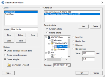
Zonal classification is a tool that will identify areas that meet a set of criteria. The criteria can be based upon scalar dataset values (from a scatter set, mesh, or grid) and/or specific material ids in a coverage.
The tool is accessed through the Zonal Classification command in the Data menu.
A zone may contain one or more criteria. A zone may identify areas that have a range of depths and also a range of velocities. Multiple zones can be evaluated at the same time. If using multiple zones, it is possible to have SMS create a separate coverage for each zone, a coverage that includes all the zones where each polygon's material identifies the zone or zones the polygon is valid for, or both a coverage for each zone and a merged coverage.
Zones and criteria associated with them can be saved and loaded from within SMS. This makes it easier to evaluate multiple scenarios using the same set of criteria.
If desired, SMS can create a log file that contains information such as the areas found in each zone.
Example
One application of zonal classification is to help quantify the amount and quality of fish habitat. Certain types of fish prefer or require different depths, velocities, and substrate. These preferences depend upon the life-cycle stage for fish.
The following demonstrates how to use zonal classification for a very simplified example to identify areas meeting a certain set of criteria. The example is fictitious and uses made up criteria.
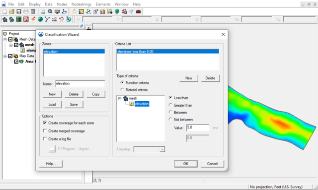
For the first sample criteria, identify areas that have an elevation of 5 ft or less. This is done by:
- Creating a new zone based upon this criteria.
- Creating a new criteria based upon a functional criteria.
- Specify the elevation dataset and the criteria to be less than 5 ft.
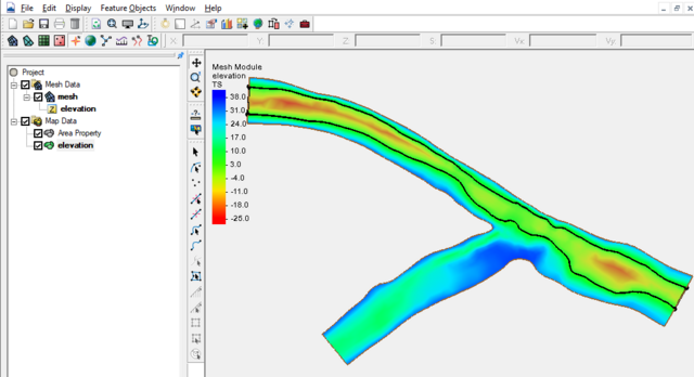
After executing the zonal classification a new coverage was created and polygons identify the areas that meet the requirements of the zone (in our case the elevation less than 5 ft). Assuming that our criteria identifies a target habitat, it is easy to see the areas that meet the criteria.
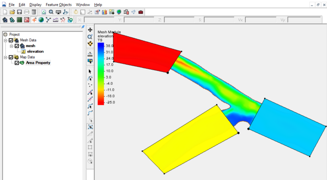
In addition to the elevation, let's assume that our target habitat also requires a specific type of substrate (bottom sediment type). For this example there are polygons created in an area property coverage and areas identified with different substrates (again this information is fictional).
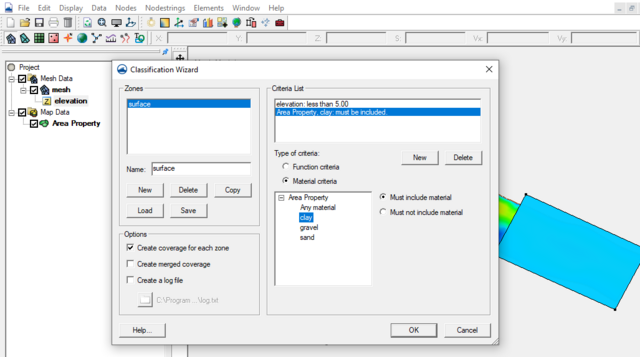
Another criteria has been added to the original zone so that the zone only includes areas that have clay substrate.
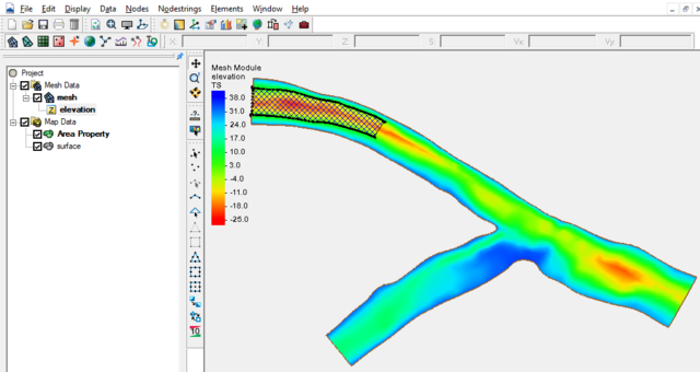
Now polygons only exist where the elevation is less than 5 ft and the substrate is clay.
References
- Jones, R. D. (2003). Vector Based Classification of Zones from Distributed Datasets Or GIS Polygon Data (Doctoral dissertation, Brigham Young University. Department of Civil and Environmental Engineering).
Related Topics
SMS – Surface-water Modeling System | ||
|---|---|---|
| Modules: | 1D Grid • Cartesian Grid • Curvilinear Grid • GIS • Map • Mesh • Particle • Quadtree • Raster • Scatter • UGrid |  |
| General Models: | 3D Structure • FVCOM • Generic • PTM | |
| Coastal Models: | ADCIRC • BOUSS-2D • CGWAVE • CMS-Flow • CMS-Wave • GenCade • STWAVE • WAM | |
| Riverine/Estuarine Models: | AdH • HEC-RAS • HYDRO AS-2D • RMA2 • RMA4 • SRH-2D • TUFLOW • TUFLOW FV | |
| Aquaveo • SMS Tutorials • SMS Workflows | ||
