GMS:GSF File Format: Difference between revisions
From XMS Wiki
Jump to navigationJump to search
(i) |
No edit summary |
||
| Line 1: | Line 1: | ||
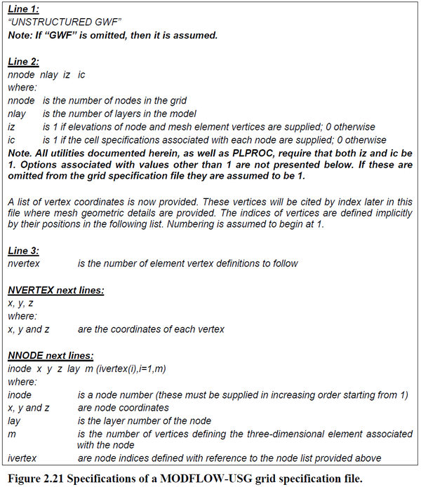
A Grid Specification File (*.gsf) is used with MODFLOW-USG to define the unstructured grid geometry. The grid specification file for a structured grid is far less complex than for an unstructured grid. The lack of structure precludes omission of the coordinates of the vertices of each model cell. Hence the locations of these vertices must be specified in the grid specification file, together with the node that is associated with a model cell. | A Grid Specification File (*.gsf) is used with MODFLOW-USG to define the unstructured grid geometry. The grid specification file for a structured grid is far less complex than for an unstructured grid. The lack of structure precludes omission of the coordinates of the vertices of each model cell. Hence the locations of these vertices must be specified in the grid specification file, together with the node that is associated with a model cell. | ||
The format is defined [http://www.pesthomepage.org/getfiles.php?file=gwutil_a.pdf | The format is defined in <!--[http://www.pesthomepage.org/getfiles.php?file=gwutil_a.pdf the Groundwater Data Utilities article] and repeated in--> the image <ref>Doherty, J. (November 2015). Groundwater Data Utilities, ''Watermark Numerical Computing'', 2(9): 26–37.</ref> below: | ||
[[Image:gsf_format.png|600px]] | [[Image:gsf_format.png|600px]] | ||
Latest revision as of 15:08, 21 April 2022
A Grid Specification File (*.gsf) is used with MODFLOW-USG to define the unstructured grid geometry. The grid specification file for a structured grid is far less complex than for an unstructured grid. The lack of structure precludes omission of the coordinates of the vertices of each model cell. Hence the locations of these vertices must be specified in the grid specification file, together with the node that is associated with a model cell.
The format is defined in the image [1] below:
References
- ^ Doherty, J. (November 2015). Groundwater Data Utilities, Watermark Numerical Computing, 2(9): 26–37.
GMS – Groundwater Modeling System | ||
|---|---|---|
| Modules: | 2D Grid • 2D Mesh • 2D Scatter Point • 3D Grid • 3D Mesh • 3D Scatter Point • Boreholes • GIS • Map • Solid • TINs • UGrids | |
| Models: | FEFLOW • FEMWATER • HydroGeoSphere • MODAEM • MODFLOW • MODPATH • mod-PATH3DU • MT3DMS • MT3D-USGS • PEST • PHT3D • RT3D • SEAM3D • SEAWAT • SEEP2D • T-PROGS • ZONEBUDGET | |
| Aquaveo | ||
