SMS:WAM Simulation Model Control: Difference between revisions
(→General Tab: updates, fix ref) |
(reflist) |
||
| Line 39: | Line 39: | ||
==Related Topics== | ==Related Topics== | ||
*[[SMS:WAM|WAM]] | *[[SMS:WAM|WAM]] | ||
==References== | |||
{{reflist}} | |||
Latest revision as of 17:59, 12 October 2018
The WAM Simulation Model Control can be accessed by right-clicking on the WAM simulation ![]() in the Project Explorer and selecting Model Control from the menu.
in the Project Explorer and selecting Model Control from the menu.
General Tab
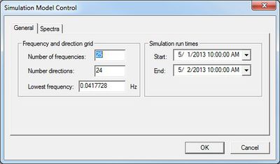
The General tab has two sections: Frequency and direction grid and Simulation run times.
Frequency and direction grid
- Number of frequencies – Defines the extent of the spectral grid. Each frequency is 10% larger than the previous frequency. With the default of 25 frequencies, the maximum frequency is 0.4114 which corresponds to approximately a 2.5 second wave.
- Number directions – Determines the size of the directional bin in the spectra. The default of 24 corresponds to a 15 degree bin.
- Lowest frequency – Defines all the frequencies in the grid, which determines the resolution and range of the spectral grids created by WAM. Each frequency is defined by the frequency before it, so this is an important parameter. The default value of “0.0417728” corresponds to approximately a 24 second wave, the minimum recommended value (longest wave period).
Starting Frequency Band
This is a very important parameter in WAM. Based on historical testing of the source terms,[1] there was a prescribed frequency range to tune the Discrete Interaction Approximation and the other source terms defined in the energy balance equation. This work used a starting frequency band of 0.04177248 Hz. Also the definition of the frequency band range is dictated by:
-
- where
- ( is number of frequency bands)
For many application this starting frequency may be too high for the case of a large-oceanic scale domain like the Pacific Ocean where there is the potential for energy carrying frequencies lower than the designated threshold (i.e. 25-sec peak spectral wave periods, where wave period is the inverse of the frequency). Also, for small-scale fully enclosed bodies of water (i.e. the Great Lakes, reservoirs etc.) the range of wave frequencies is much higher, where the lowest frequency may be on the order of 0.0833-Hz (or 12-sec). The initial frequency value can be changed, upward or downward, as long as the range of frequency values can be defined from the 0.0417728-Hz standard. For the example of the Pacific Ocean implementation, a starting value of 0.03138428-Hz is used, where f(4) = 0.0417728-Hz as defined by the above equation. Setting a higher starting point for a Great Lakes simulation and knowledge of the wave climate an initial value could be 0.050545-Hz. Standard practices use conservatism allowing for energy to be transferred. Also, it is also advantageous to set the first frequency band high enough to minimize the computational time, where the propagation of wave energy is dictated by the group speed of the first frequency band. The lower the frequency, the shorter the stable propagation time step. The number of direction bands is nominally set to 24 or a 15-deg directional resolution of the wave spectra. Selection of a higher directional resolution (or increasing the number of directional bins) will linearly increase computational time because the directional loop is the outer-most loop in all of WAM’s calculations.
Simulation run times
The starting and ending time of the simulation must be entered in this section. The run times must be less or equal to the time available for wind data. Time is given in MM/DD/YYYY HH:MM:SS AM/PM format.
- Start – Indicates when the simulation is to begin.
- End – Indicates when to simulation is to stop. Can be used to reduce the run time.
Spectra Tab
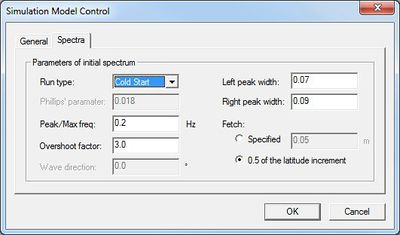
The parameters in the Spectra tab with the exception of Fetch are Jonswap parameters.
- Run type – Can be set as "Cold Start" or "Hot Start". The "Hot Start" option requires a hot start file generated from a previous run.
- Phillips' parameter
- Peak/Max freq
- Overshoot factor
- Wave direction
- Left peak width
- Right peak width
- Fetch
- Specified
- 0.5 of the latitude increment
Related Topics
References
- ^ Komen, G. J.; Cavaleri, L.; Donelan, M.; Hasselmann, S.; Janssen, P. A. E. M. (1994). "Dynamics and modelling of ocean waves". Cambridge University Press. https://www.cambridge.org/core/books/dynamics-and-modelling-of-ocean-waves/767155B50D6E29B0F62729F29C2DE124. Retrieved on October 12, 2018.
SMS – Surface-water Modeling System | ||
|---|---|---|
| Modules: | 1D Grid • Cartesian Grid • Curvilinear Grid • GIS • Map • Mesh • Particle • Quadtree • Raster • Scatter • UGrid |  |
| General Models: | 3D Structure • FVCOM • Generic • PTM | |
| Coastal Models: | ADCIRC • BOUSS-2D • CGWAVE • CMS-Flow • CMS-Wave • GenCade • STWAVE • WAM | |
| Riverine/Estuarine Models: | AdH • HEC-RAS • HYDRO AS-2D • RMA2 • RMA4 • SRH-2D • TUFLOW • TUFLOW FV | |
| Aquaveo • SMS Tutorials • SMS Workflows | ||


