GMS:HydroGeoSphere: Difference between revisions
| Line 29: | Line 29: | ||
**'''Materials''' – Opens the HGS ''Materials'' dialog. | **'''Materials''' – Opens the HGS ''Materials'' dialog. | ||
**'''Export''' – Saves out the simulation files. | **'''Export''' – Saves out the simulation files. | ||
**'''Run grok''' – Opens the ''Run grok.exe'' dialog where GMS will generate the GROK file. The GROK file contains all of the information and instructions required for the HGS | **'''Run grok''' – Opens the ''Run grok.exe'' dialog where GMS will generate the GROK file. The GROK file contains all of the information and instructions required for the HGS simulation. | ||
simulation. | |||
**'''Run phgs''' – | **'''Run phgs''' – | ||
**'''Run hsplot''' – | **'''Run hsplot''' – | ||
Revision as of 20:20, 22 September 2023
| This contains information currently under development. The content may change often. |
HydroGeoSphere (HGS) is a three-dimensional control-volume finite element simulator created by Aquanty. HGS can be used to model the entire terrestrial portion of the hydrologic cycle. It uses a globally-implicit approach to simultaneously solve the 2D diffusive-wave equation for overland/surface water flow and the 3D form of Richards’ equation for variably saturated groundwater flow.
Graphical Interface
The GMS interface for HydroGeoSphere contains multiple components. These components include:
- An unstructured grid (UGrid)
- HGS coverages
- HGS simulation, including the Simulation Control
Building a HydroGeoSphere Simulation
Before building a HydroGeoSphere (HGS) simulation, a 3D UGrid of the project area is required. While the project can contain multiple UGrids, only one UGrid can be attached to each HGS simulation.
To create a MODFLOW simulation:
- Right-click on an empty space in the Project Explorer, or right-click on "
 Project" in the Project Explorer, and select New Simulation | HydroGeoSphere.
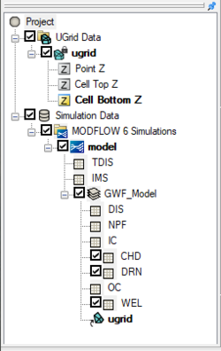
When the simulation has been initially created, the selected UGrid will be linked to the simulation and the simulation packages will appear in the Project Explorer.
HGS Simulation Right-Click Menus
In the Project Explorer, right-clicking on a HGS simulation brings up a menu with several commands. Some of these commands are common to other Project Explorer In the Project Explorer, right-clicking on HGS simulation brings up a menu with several commands. Some of these commands are common to other Project Explorer right-click menus. Others are unique to the simulation right-click menus. Some of these unique commands are:
- "
 Simulation Data"
- Simulation Run Queue – Opens the Simulation Run Queue dialog which shows all current simulation runs.
- "
 HydroGeoSphere Simulations"
- New Simulation – Creates a new MODFLOW 6 simulation in the Project Explorer. This simulation will not contain any of the packages in any existing simulations and therefor the packages must be added. Also, creating a new simulation using this method requires linking a UGrid to the simulation.
- Save Multiple Simulations – Saves all HGS simulations in the project and exports all files needed for the model run.
 Model
Model
- Simulation Control – Opens the Simulation Control dialog where the HGS simulation .
- Materials – Opens the HGS Materials dialog.
- Export – Saves out the simulation files.
- Run grok – Opens the Run grok.exe dialog where GMS will generate the GROK file. The GROK file contains all of the information and instructions required for the HGS simulation.
- Run phgs –
- Run hsplot –
- Solution Plots –
- Save Simulation – Saves the simulation and exports all files needed for the model run.
- Save Project and Simulation – Saves the simulation and exports all files needed for the model run.
- Read Solution – Loads the solution file for the associated simulation. Requires that the simulation has had a successful run.
Modeling Notes
- GMS allows multiple HGS simulations to exist in a single GMS project.
HGS Files
External Links
GMS – Groundwater Modeling System | ||
|---|---|---|
| Modules: | 2D Grid • 2D Mesh • 2D Scatter Point • 3D Grid • 3D Mesh • 3D Scatter Point • Boreholes • GIS • Map • Solid • TINs • UGrids | |
| Models: | FEFLOW • FEMWATER • HydroGeoSphere • MODAEM • MODFLOW • MODPATH • mod-PATH3DU • MT3DMS • MT3D-USGS • PEST • PHT3D • RT3D • SEAM3D • SEAWAT • SEEP2D • T-PROGS • ZONEBUDGET | |
| Aquaveo | ||
