GMS:Importing/Exporting CAD Data: Difference between revisions
| Line 12: | Line 12: | ||
==CAD Properties== | ==CAD Properties== | ||
The ''CAD Properties'' dialog displays data about the CAD file such as: path on disk, extents in xy, and file version. | The ''CAD Properties'' dialog displays data about the CAD file such as: path on disk, extents in xy, and file version. | ||
[[File:CAD Properties.png|thumb|none|280 px|Example of the ''CAD Properties'' dialog]] | |||
[[Category:GMS Dialogs|I]] | [[Category:GMS Dialogs|I]] | ||
Revision as of 19:52, 17 March 2016
Importing
GMS can import DWG or DXF files via the File | Open command. If there is already CAD data in memory, GMS will replace the existing data with the data being imported. Currently, GMS cannot merge the incoming data with the data in memory.
Exporting
GMS data can be exported to a DWG or DXF file that can then be read into a CAD software package. If there is CAD data in memory when a GMS project is saved, GMS creates a new DWG file from the CAD data. The file is put in the same folder with the other project files and named using the project prefix.
Any CAD data in memory can be exported by right-clicking the CAD folder in the Project Explorer and selecting the Export command. The DWG/DXF Filename dialog will appear. Either the DWG of DXF file types can be selected when saving CAD data. GMS objects must first be converted to CAD data before CAD data can be exported. To convert GMS data to CAD data, use the Convert To CAD command in the Display Menu.
Starting at GMS 9.0, multiple CAD files can be included in the project at once. GMS does not write to these files when the GMS project is saved, it merely links to the CAD files.
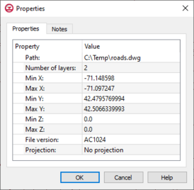
CAD Properties
The CAD Properties dialog displays data about the CAD file such as: path on disk, extents in xy, and file version.
See also
| [hide] GMS – Groundwater Modeling System | ||
|---|---|---|
| Modules: | 2D Grid • 2D Mesh • 2D Scatter Point • 3D Grid • 3D Mesh • 3D Scatter Point • Boreholes • GIS • Map • Solid • TINs • UGrids | |
| Models: | FEFLOW • FEMWATER • HydroGeoSphere • MODAEM • MODFLOW • MODPATH • mod-PATH3DU • MT3DMS • MT3D-USGS • PEST • PHT3D • RT3D • SEAM3D • SEAWAT • SEEP2D • T-PROGS • ZONEBUDGET | |
| Aquaveo | ||
