GMS:GSF File Format: Difference between revisions
From XMS Wiki
Jump to navigationJump to search
No edit summary |
No edit summary |
||
| Line 1: | Line 1: | ||
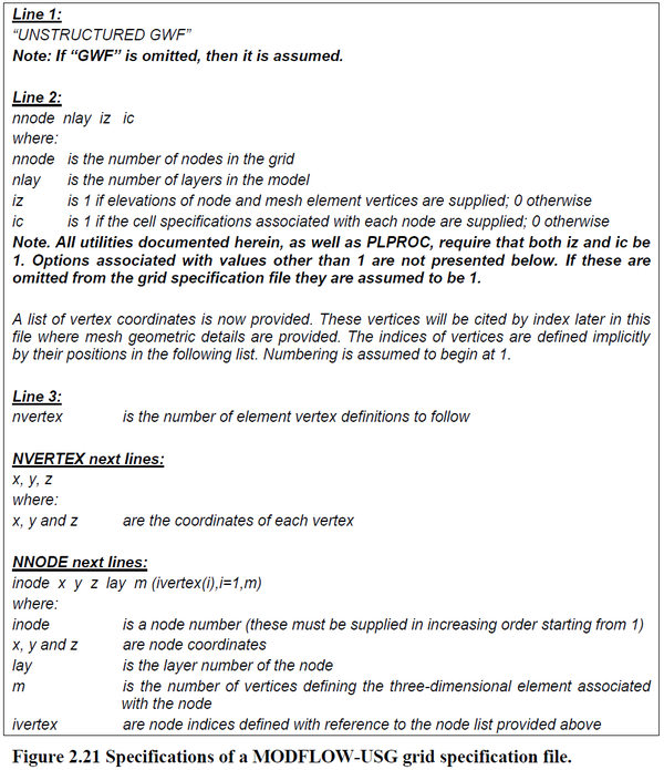
A Grid Specification File (*.gsf) is used with MODFLOW-USG to define the unstructured grid geometry. The format is defined ([http://www.pesthomepage.org/getfiles.php?file=gwutil_a.pdf in this link]) and repeated in the image <ref>Dohert, J. (November 2015). Groundwater Data Utilities, ''Watermark Numerical Computing'', 13 | A Grid Specification File (*.gsf) is used with MODFLOW-USG to define the unstructured grid geometry. The format is defined ([http://www.pesthomepage.org/getfiles.php?file=gwutil_a.pdf in this link]) and repeated in the image <ref>Dohert, J. (November 2015). Groundwater Data Utilities, ''Watermark Numerical Computing'', 13–15.</ref> below: | ||
[[Image:gsf_format.png|600px]] | [[Image:gsf_format.png|600px]] | ||
Revision as of 18:56, 28 October 2016
A Grid Specification File (*.gsf) is used with MODFLOW-USG to define the unstructured grid geometry. The format is defined (in this link) and repeated in the image [1] below:
References
- ^ Dohert, J. (November 2015). Groundwater Data Utilities, Watermark Numerical Computing, 13–15.
| [hide] GMS – Groundwater Modeling System | ||
|---|---|---|
| Modules: | 2D Grid • 2D Mesh • 2D Scatter Point • 3D Grid • 3D Mesh • 3D Scatter Point • Boreholes • GIS • Map • Solid • TINs • UGrids | |
| Models: | FEFLOW • FEMWATER • HydroGeoSphere • MODAEM • MODFLOW • MODPATH • mod-PATH3DU • MT3DMS • MT3D-USGS • PEST • PHT3D • RT3D • SEAM3D • SEAWAT • SEEP2D • T-PROGS • ZONEBUDGET | |
| Aquaveo | ||
