SMS:Create Spectral Energy Grid: Difference between revisions
From XMS Wiki
Jump to navigationJump to search
| Line 21: | Line 21: | ||
== Angle Distribution == | == Angle Distribution == | ||
* | * ''Number'' – View the number of angle bands (Number = 35). | ||
* | * ''Delta'' – Set the step size (Delta = 5) in degrees. | ||
* | * ''Minimum'' – View the minimum angle (Minimum = 0.0) in degrees. | ||
* | * ''Maximum'' – View the maximum angle (Maximum = 360.0) in degrees. | ||
==Related Topics== | ==Related Topics== | ||
Revision as of 14:42, 17 July 2017
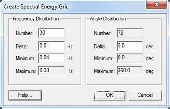
The Create Spectral Energy Grid dialog is accessed through the Spectral Energy dialog (by pushing the Create Grid button). Prior to reaching this dialog, the Spectral Grid Attributes dialog will appear. A spectral energy grid is created after setting the options. All units for the options are hertz and degrees. The new spectral energy grid will be displayed in the Spectral Manager and the Spectral Viewer in the Spectral Energy dialog.'
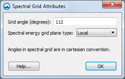
Spectral Grid Attributes
This dialog is used to set the spectral grid parameters when creating a spectral energy grid. The dialog has the following options:
- Grid angle – The angle of the grid can be altered if wanting the grid to vary from existing Cartesian grid.
- Spectral energy grid plane type – Can be set to "Local" or "Global" to indicate which projection for the spectral energy grid to use.
Plane Type and Angle
- Plane type (full global, full local, half local) – Sets the plane type for the spectral data
- Angle – Sets the grid orientation
Frequency Distribution
- Number – Set the number of frequency bands (Number = 30)
- Delta – Set the step size (Delta = 0.01) in Hz.
- Minimum – Set the minimum frequency (Minimum = 0.04) in Hz.
- Maximum – View the maximum frequency (Maximum = 0.33) in Hz.
Angle Distribution
- Number – View the number of angle bands (Number = 35).
- Delta – Set the step size (Delta = 5) in degrees.
- Minimum – View the minimum angle (Minimum = 0.0) in degrees.
- Maximum – View the maximum angle (Maximum = 360.0) in degrees.
Related Topics
SMS – Surface-water Modeling System | ||
|---|---|---|
| Modules: | 1D Grid • Cartesian Grid • Curvilinear Grid • GIS • Map • Mesh • Particle • Quadtree • Raster • Scatter • UGrid |  |
| General Models: | 3D Structure • FVCOM • Generic • PTM | |
| Coastal Models: | ADCIRC • BOUSS-2D • CGWAVE • CMS-Flow • CMS-Wave • GenCade • STWAVE • WAM | |
| Riverine/Estuarine Models: | AdH • HEC-RAS • HYDRO AS-2D • RMA2 • RMA4 • SRH-2D • TUFLOW • TUFLOW FV | |
| Aquaveo • SMS Tutorials • SMS Workflows | ||

