GMS:DPT Package: Difference between revisions
| Line 8: | Line 8: | ||
==Comments== | ==Comments== | ||
Comment lines can be added and will appear at the top of the DPT file. Use the '''Add Row''' [[File:Insert Row Icon.svg|16 px]] button to create comments. Comments can be removed using the '''Delete Row''' [[File:Delete Row Icon.svg|16 px]] button. | Comment lines can be added and will appear at the top of the DPT file. Use the '''Add Row''' [[File:Insert Row Icon.svg|16 px]] button to create comments. Comments can be removed using the '''Delete Row''' [[File:Delete Row Icon.svg|16 px]] button. | ||
==Variables== | |||
Variables corresponding to item 1a in the DPT input file. | |||
==Aquifer Properties== | ==Aquifer Properties== | ||
Revision as of 18:13, 21 August 2018
| This contains information about functionality available starting at GMS version 10.4. The content may not apply to other versions. |
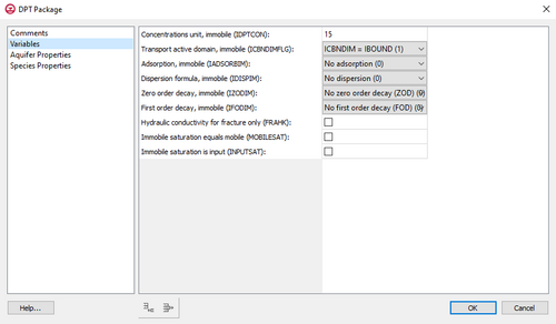
The Dual Porosity Transport (DPT) package is used for solutions to contaminant transportation in a steady state or transient flow field in the immobile domain of the dual porosity system.
The DPT Package dialog is divided into two parts: one on the left which shows the main sections, and one on the right which shows the inputs for the current section.
Comments
Comment lines can be added and will appear at the top of the DPT file. Use the Add Row ![]() button to create comments. Comments can be removed using the Delete Row
button to create comments. Comments can be removed using the Delete Row ![]() button.
button.
Variables
Variables corresponding to item 1a in the DPT input file.
Aquifer Properties
Cell-by-cell inputs independent of species such as porosity. The table in this section contains four columns.
- Property Name
- Use Constant
- Constant Value
- Array Editor
Species Properties
Cell-by-cell inputs that depend on the species, such as adsorption. The table in this section contains five columns.
- Species ID
- Property Name
- Use Constant
- Constant Value
- Array Editor
GMS – Groundwater Modeling System | ||
|---|---|---|
| Modules: | 2D Grid • 2D Mesh • 2D Scatter Point • 3D Grid • 3D Mesh • 3D Scatter Point • Boreholes • GIS • Map • Solid • TINs • UGrids | |
| Models: | FEFLOW • FEMWATER • HydroGeoSphere • MODAEM • MODFLOW • MODPATH • mod-PATH3DU • MT3DMS • MT3D-USGS • PEST • PHT3D • RT3D • SEAM3D • SEAWAT • SEEP2D • T-PROGS • ZONEBUDGET | |
| Aquaveo | ||
