GMS:Time Settings: Difference between revisions
No edit summary |
No edit summary |
||
| Line 7: | Line 7: | ||
* XY Series input | * XY Series input | ||
The ''Time Settings'' dialog can be used to format dates and times using the computer's regional settings, or using a number of other formats. The ''Specify precision'' command allows for specifying the number of decimal places to include in the selected relative time format. The accepted values range from "1" to "10". | The ''Time Settings'' dialog can be used to format dates and times using the computer's regional settings, or using a number of other formats. The ''Specify precision'' command allows for specifying the number of decimal places to include in the selected relative time format. The accepted values range from "1" to "10". This option is only available when using certain options. | ||
==Date/Time vs. Relative== | ==Date/Time vs. Relative== | ||
Revision as of 21:47, 14 March 2022
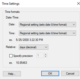
The Time Settings dialog is used to control how dates and times are displayed in GMS. The dialog is reached through the Edit | Time... menu command. Time data can be encountered in various places in GMS such as:
- Transient datasets
- MODFLOW stress period input
- XY Series input
The Time Settings dialog can be used to format dates and times using the computer's regional settings, or using a number of other formats. The Specify precision command allows for specifying the number of decimal places to include in the selected relative time format. The accepted values range from "1" to "10". This option is only available when using certain options.
Date/Time vs. Relative
Time data that has an associated reference time—a real calendar date and time—can be displayed as dates/times. Time data that lacks a reference time can only display as relative times which are simple scalar values (0.0, 2.0, 3.0 etc).
GMS – Groundwater Modeling System | ||
|---|---|---|
| Modules: | 2D Grid • 2D Mesh • 2D Scatter Point • 3D Grid • 3D Mesh • 3D Scatter Point • Boreholes • GIS • Map • Solid • TINs • UGrids | |
| Models: | FEFLOW • FEMWATER • HydroGeoSphere • MODAEM • MODFLOW • MODPATH • mod-PATH3DU • MT3DMS • MT3D-USGS • PEST • PHT3D • RT3D • SEAM3D • SEAWAT • SEEP2D • T-PROGS • ZONEBUDGET | |
| Aquaveo | ||
