GSSHA 2D UGrid Tool: Difference between revisions
From XMS Wiki
Jump to navigationJump to search
(Replaced content with "__NOINDEX__ {{GSSHA 2D UGrid Tool}} {{Navbox SMS}} Category:Toolbox") Tag: Replaced |
|||
| Line 1: | Line 1: | ||
__NOINDEX__ | |||
{{GSSHA 2D UGrid Tool}} | |||
{ | |||
{{Navbox SMS}} | |||
[[Category:Toolbox]] | |||
Latest revision as of 18:24, 29 March 2024
GSSHA 2D UGrid
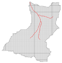
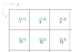
Given a coverage and cell size, creates a rectilinear 2D UGrid with a cell-based elevation dataset, numbered the GSSHA way, with cells outside the domain inactivated. Cells are numbered starting in the top, left corner, in row-major order. An elevation raster can be used when computing cell elevations. Stream elevations can be included in the calculation of the cell elevation dataset.
Input Parameters
- Input GSSHA Boundary Conditions coverage – The GSSHA Boundary Conditions coverage. The grid extents will be determined from the coverage extents. If a stream network exists, the stream elevations can be included when computing the cell elevation dataset (see “Include streams in cell elevations” below).
- Cell size – Width and height of the cells. Cells are always square. A default value is provided that will result in 60 cells in the direction (X or Y) with the smallest length.
- Output grid name – Name of the grid to be created. Optional.
- Get cell elevations from raster – Option to use an elevation raster when computing the cell-based elevation dataset. The raster value at the cell center is used, without interpolation.
- Raster – The elevation raster if the Get cell elevations from raster option is selected.
- Include streams in cell elevations – If selected, and the boundary conditions coverage contains stream arcs, the arcs are intersected with the grid and intersected cells are assigned the elevations of the arcs based on a weighted average of the intersected portion of the arc in the cell.
Output Parameters
- UGrid – The new UGrid that will be created.
Current Location in Toolbox
GSSHA | GSSHA 2D UGrid
SMS – Surface-water Modeling System | ||
|---|---|---|
| Modules: | 1D Grid • Cartesian Grid • Curvilinear Grid • GIS • Map • Mesh • Particle • Quadtree • Raster • Scatter • UGrid |  |
| General Models: | 3D Structure • FVCOM • Generic • PTM | |
| Coastal Models: | ADCIRC • BOUSS-2D • CGWAVE • CMS-Flow • CMS-Wave • GenCade • STWAVE • WAM | |
| Riverine/Estuarine Models: | AdH • HEC-RAS • HYDRO AS-2D • RMA2 • RMA4 • SRH-2D • TUFLOW • TUFLOW FV | |
| Aquaveo • SMS Tutorials • SMS Workflows | ||

