SMS:SRH Monitor Points Coverage: Difference between revisions
No edit summary |
No edit summary |
||
| Line 1: | Line 1: | ||
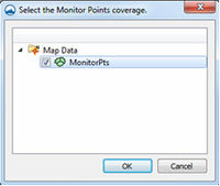
[[File:SRHmonitorpointscoverage.jpg|thumb|200 px|The SRH ''Select the Monitor Points coverage'' dialog.]] | [[File:SRHmonitorpointscoverage.jpg|thumb|200 px|The SRH ''Select the Monitor Points coverage'' dialog.]] | ||
Monitor Points are optional. If choosing to have monitor points, the user should create a monitor points coverage and add points using the '''Create Feature Point''' tool. A monitor point is used to gather specific information for that location at all time steps. Information calculated by SRH at a monitor point includes position in the X and Y direction, bed elevation, water elevation, water depth, X direction velocity component, Y direction velocity component, velocity magnitude, Froude number, and shear stress. If a Monitor | Monitor Points are optional. If choosing to have monitor points, the user should create a monitor points coverage and add points using the '''Create Feature Point''' tool. A monitor point is used to gather specific information for that location at all time steps. Information calculated by SRH at a monitor point includes position in the X and Y direction, bed elevation, water elevation, water depth, X direction velocity component, Y direction velocity component, velocity magnitude, Froude number, and shear stress. If a Monitor Points Coverage has been created, then it must be assigned and selected in the ''Select the Monitor Point Coverage'' dialog for SRH to recognize them. The dialog is accessed through the '''Assign Monitor Point Coverage''' command in the ''SRH'' menu. | ||
==Related Topics== | ==Related Topics== | ||
Revision as of 18:16, 9 January 2014
Monitor Points are optional. If choosing to have monitor points, the user should create a monitor points coverage and add points using the Create Feature Point tool. A monitor point is used to gather specific information for that location at all time steps. Information calculated by SRH at a monitor point includes position in the X and Y direction, bed elevation, water elevation, water depth, X direction velocity component, Y direction velocity component, velocity magnitude, Froude number, and shear stress. If a Monitor Points Coverage has been created, then it must be assigned and selected in the Select the Monitor Point Coverage dialog for SRH to recognize them. The dialog is accessed through the Assign Monitor Point Coverage command in the SRH menu.
Related Topics
SMS – Surface-water Modeling System | ||
|---|---|---|
| Modules: | 1D Grid • Cartesian Grid • Curvilinear Grid • GIS • Map • Mesh • Particle • Quadtree • Raster • Scatter • UGrid |  |
| General Models: | 3D Structure • FVCOM • Generic • PTM | |
| Coastal Models: | ADCIRC • BOUSS-2D • CGWAVE • CMS-Flow • CMS-Wave • GenCade • STWAVE • WAM | |
| Riverine/Estuarine Models: | AdH • HEC-RAS • HYDRO AS-2D • RMA2 • RMA4 • SRH-2D • TUFLOW • TUFLOW FV | |
| Aquaveo • SMS Tutorials • SMS Workflows | ||
