SMS:RMA2 Boundary Conditions
From XMS Wiki
Jump to navigationJump to search
Assigning Boundary Conditions
Boundary conditions are generally defined on nodestrings but may also be defined on nodes. The default boundary condition is a closed boundary (no flow).
Deleting Boundary Conditions
Boundary conditions are removed using the menu command RMA2 | Delete BC.
Nodal Boundary Conditions
File:RMA2 Nodal BC.jpg
RMA2 Nodal Boundary Conditions dialog
Boundary Condition Type
- None
- Water Surface Elevation
- A water surface elevation BC is assigned to this Nodestring. This boundary condition is normally located at the tailwater location. However. RMA2 does sometime edit the water depth at the exit boundary to satisfy the finite element equations.
- Velocity Components
- Unit Flowrate
- No Slip Condition
Boundary Angle
- Specify Flow Direction
- Perpendicular into Boundary
- Perpendicular out of Boundary
- Specified angle
Optional Parameters
- Water Density
- Include in node summary file
Boundary Condition Value
- Constant
- Transient
Nodestring Boundary Conditions
File:RMA2 Assign BC.jpg
RMA2 Nodestring Boundary Conditions dialog
Boundary Condition Type
- None
- No Boundary Condition is assigned to this nodestring.
- Specified Flow Rate
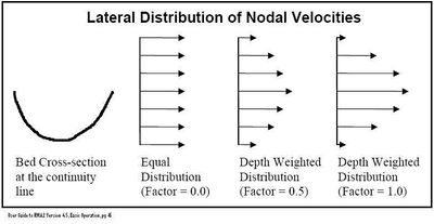
- A flow rate BC is assigned to this nodestring. It is the most popular way to provide a total flow across a particular continuity line. The total flow (cubic units per second), flow angle (degrees from positive x-axis) and distribution factor can be specified.
- Water Surface Elevation
- A water surface elevation BC is assigned to this nodestring. This boundary condition is normally located at the tailwater location. (However RMA2 does sometime edit the water depth at the exit boundary to satisfy the finite element equations.)
- Reflecting Boundary
- Considered an advanced feature – for more information see the "Boundary Permeability (Reflection/Absorption)" section on page 99 of the Users Guide to RMA2 version 4.5.
- Rating Curve
- A rating curve can also be defined by selecting the Options... button.
Flow Rate
- Constant
- Transient
Boundary Reflection
- Steady state water surface
- Tidal storage surface area
Flow Direction
- Degree CCW from positive X axis
- Perpendicular to boundary
Advanced Options
- Make this nodestring the "Total Flow" nodestring
- Specify vorticity
Flow Distribution
- A real number between 0.0 and 1.0, that is used to weight the nodal x and y velocity components according to the nodal depths and friction across the continuity line.
Extract Nodal Boundary Conditions
File:RMA2extractBC.jpg
Example of the Extract Nodal Boundary Condition dialog.
- Boundary Condition Type
- "None"
- "Water surface elevation"
- "Velocity"
- "Unit-Flow"
- Specify Flow Direction
- Perpendicular info boundary
- Perpendicular out of boundary
- Specified Angle
- Extract
File:RMA2extractBC2.jpgExample of the Extract Boundary Conditions dialog.
- View Extracted
Related Topics
SMS – Surface-water Modeling System | ||
|---|---|---|
| Modules: | 1D Grid • Cartesian Grid • Curvilinear Grid • GIS • Map • Mesh • Particle • Quadtree • Raster • Scatter • UGrid |  |
| General Models: | 3D Structure • FVCOM • Generic • PTM | |
| Coastal Models: | ADCIRC • BOUSS-2D • CGWAVE • CMS-Flow • CMS-Wave • GenCade • STWAVE • WAM | |
| Riverine/Estuarine Models: | AdH • HEC-RAS • HYDRO AS-2D • RMA2 • RMA4 • SRH-2D • TUFLOW • TUFLOW FV | |
| Aquaveo • SMS Tutorials • SMS Workflows | ||
