User:Jcreer/SMS:SRH-2D Floodway Tools
From XMS Wiki
Jump to navigationJump to search
Generate Floodway Simulation
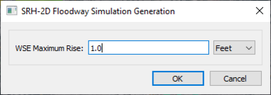
The Generate Floodway Simulation tool creates a new SHR-2D simulation to evaluate a floodway. The tool is accessed using the SRH-2D simulation right-click menu selecting the Floodway Tools | Generate Floodway Simulations command. The tool will bring up the SRH-2D Floodway Simulation Generation dialog. The dialog has the following options:
- WSE Maximum Rise – The maximum rise for the water surface elevation in the floodway simulation. This value should be positive.
- Units – Set the units for the WSE maximum rise. The units should match the project units.
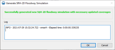
After completing the SRH-2D Floodway Simulation Generation dialog and clicking OK, the Generate SRH-2D Floodway Simulation dialog will appear showing the progress for the generation of the floodway simulation. If there are errors during the generation process, they will appear in this dialog. When the generation process proceeds successfully, a message will appear.
Generate Floodway Elevation Lines
Compare Floodway Simulation Data
Related Topics
SMS – Surface-water Modeling System | ||
|---|---|---|
| Modules: | 1D Grid • Cartesian Grid • Curvilinear Grid • GIS • Map • Mesh • Particle • Quadtree • Raster • Scatter • UGrid |  |
| General Models: | 3D Structure • FVCOM • Generic • PTM | |
| Coastal Models: | ADCIRC • BOUSS-2D • CGWAVE • CMS-Flow • CMS-Wave • GenCade • STWAVE • WAM | |
| Riverine/Estuarine Models: | AdH • HEC-RAS • HYDRO AS-2D • RMA2 • RMA4 • SRH-2D • TUFLOW • TUFLOW FV | |
| Aquaveo • SMS Tutorials • SMS Workflows | ||

