SMS:Metadata
Metadata, or data about data, can be crucial in the modeling process. In many situations, metadata is saved in a separate file (called a metadata file). A common problem is that metadata and the data it describes are often separated. Metadata is of little value without the data files it relates too. At the same time, metadata makes the data more usable and therefore, more valuable.
In the SMS, metadata can be cataloged inside the project file. Metadata can be associated with the project as a whole, a single geometric object such as a survey or finite element domain, or individual components down to the dataset level.
Project/Geometric Object Metadata
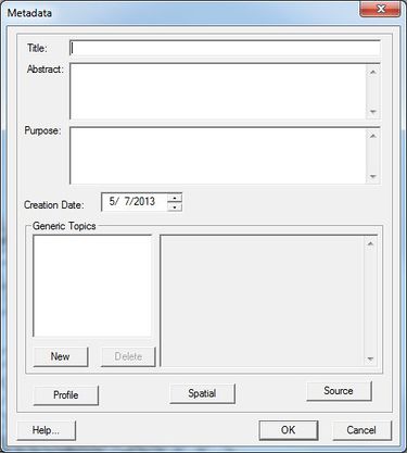
The project metadata can be accessed through the Edit|Metadata... command. Object metadata can be accessed by right-clicking on the object and choosing the Metadata... command. Either method invokes the Metadata dialog which includes edit fields for the following metadata:
- Title of the project or object
- Abstract – a brief description
- Purpose – this can change over time, but if it is recorded with the project when generated, it provides a valuable backdrop when applying the project for other purposes at later times.
- Creation Date – This is filled in automatically to the current date when the project is created. It can be edited if an existing project is simply being organized.
- General Topics – This section includes a list of topics and description or blurb for each topic. As the project develops or is modified, notes of these developments, consisting of dates, individuals involved, purposes, etc, can be annotated to the project.
- Profile – this button invokes the Profile Information dialog which documents who created this project and provides information about this individual. The profile can be set up and associated with an installation of SMS and then this information is automatically added to all projects created with this installation. In order to associate a profile as the default, simply click the Use Current for Default button in the Profile Information dialog.
- Spatial – this button invokes the Spatial Metadata dialog displaying the projection used by the project and the spatial limits of the project. This information is automatically filled in.
- Source – this button is only available for objects (not the project as a whole). It brings up a the Source Metadata dialog. Whenever SMS generates a new object, such as a mesh from a conceptual module, or reads in a new object from a file, the source is recorded. In the former case, the coverage and scatter set used will be recorded. In the latter, the filename. This dialog allows the modeler to record additional notes about this object.
Dataset Metadata
Dataset metadata is accessed by right-clicking on the dataset. This invokes the Dataset Metadata dialog which includes a text string describing the dataset.
SMS – Surface-water Modeling System | ||
|---|---|---|
| Modules: | 1D Grid • Cartesian Grid • Curvilinear Grid • GIS • Map • Mesh • Particle • Quadtree • Raster • Scatter • UGrid |  |
| General Models: | 3D Structure • FVCOM • Generic • PTM | |
| Coastal Models: | ADCIRC • BOUSS-2D • CGWAVE • CMS-Flow • CMS-Wave • GenCade • STWAVE • WAM | |
| Riverine/Estuarine Models: | AdH • HEC-RAS • HYDRO AS-2D • RMA2 • RMA4 • SRH-2D • TUFLOW • TUFLOW FV | |
| Aquaveo • SMS Tutorials • SMS Workflows | ||
