SMS:SRH-2D Coverages
The SRH-2D model makes use of the simulation based modeling approach. This means that the user defines coverages in the Map module to build the components for use in the SRH Simulation.
Boundary Conditions Coverage
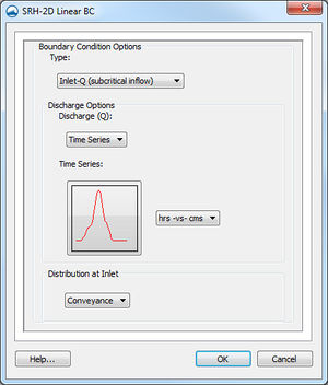
SRH support a variety of boundary conditions for hydraulic computation. The boundary conditions for the model are specified through the SRH Boundary Condistion coverage by selecting an arc or by selecting a nodestring in the mesh. Once the arc or nodestring has been selected, double-clicking, or right-clicking and using the Assign Linear BC... command, will bring up a dialog where the boundaries can be assigned.
All currently supported boundary types are exterior boundaries with the exception of a monitor line. Other boundary types include the following: Inlet-Q, Inlet-SC, Exit-EX, Exit-H, Exit-Q, Wall, and Symmetry.
- Inlet-Q is a subcritical inlet boundary that may be given as a constant discharge or as a variable discharge hydrograph. The velocity distribution type may be selected from the boundary condition menu.
- Inlet-SC is a supercritical inlet boundary that may be given as a constant discharge or as a variable discharge hydrograph. Inlet-SC also requires information about depth. Within the boundary condition menu, the velocity distribution type may be specified.
- Exit-EX is a supercritical exit boundary condition.
- Exit-H is a stage type exit boundary where water surface elevation may be given as a constant number or as a stage-discharge or rating curve.
- Exit-Q is and exit boundary with a discharge given as a constant number or as a hydrograph.
- Wall
- Symmetry
- Monitor-Line
- Weir – See the SRH Structures article for more information.
- Culvert – See the SRH Structures article for more information.
- Pressure zone – See the SRH Structures article for more information.
- Gate – See the SRH Structures article for more information.
Boundary Conditions Coverage Right-Click Menu
The boundary conditions coverage has the standard coverage item right-click menu commands as well as specific right-click commands. The following commands are also part of the SRH-2D boundary conditions coverage:
- Options... – Opens the Coverage Options dialog. This dialog allows specifying an HY-8 file for use in creating culvert structures.
Obstructions Coverage
Used to create feature objects that represent obstructions, such as bank protrusions and boulder clusters. Obstructions can be assigned to feature arcs or points.
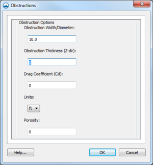
When this coverage is active, double-clicking on a feature arc or point, or right-clicking on an arc or point followed by selecting the Assign Obstructions... command, will bring up the Obstructions dialog.
The Obstructions dialog has the following options:
- Obstruction Width/Diameter – Each arc segment represents a rectangular area based on the assigned width. Each point represents a circular diameter based on the assigned width.
- Obstruction Thickness (Z-dir)
- Drag Coefficient (Cd)
- Units – May be assigned to either "ft" (feet) or "m" (meters).
- Porisity
Monitor Points Coverage
Monitor Points are optional. If choosing to have monitor points, the user should create a monitor points coverage and add points using the Create Feature Point tool. A monitor point is used to gather specific information for that location at all time steps. Information calculated by SRH at a monitor point includes position in the X and Y direction, bed elevation, water elevation, water depth, X direction velocity component, Y direction velocity component, velocity magnitude, Froude number, and shear stress.
If a Monitor Points coverage has been created, then it must be linked to the SRH-2D simulation. This can be done by dragging the coverage under the simulation item in the Project Explorer or right-clicking on the coverage and using the Link to menu item. When the simulation is launched, monitoring point data will be collected and outputted.
In SMS 11.2 only, the Monitor Points coverage must be assigned and selected in the Select the Monitor Point Coverage dialog for SRH to recognize them. The dialog is accessed through the Assign Monitor Points Coverage command in the SRH-2D menu. This process is obsolete in SMS 12.0 and higher.
Materials Coverage
The SRH-2D materials coverage allows creating material zones specific to the SRH-2D model. The materials zones must cover the domain extents of the project.
Materials Coverage Right-Click Menu
The materials coverage has the standard coverage item right-click menu commands as well as specific right-click commands. The following commands are also part of the SRH-2D materials coverage:
- Material Properties – Opens the Material Properties dialog.
- Assign Material To – Opens the Assign Materials dialog for managing multiple material coverages.
Assign Materials
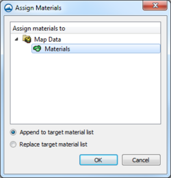
SRH-2D allows the option to have multiple material coverages. When multiple material coverages exist, there are options to manages these coverages. By right-clicking on an SRH materials coverage and selecting the Assign Materials to... command, the Assign Materials dialog can be accessed. This dialog allows adding the unique material definition of one material coverage to that of another material coverage. The user must select the target material coverage that will be modified by the material coverage the user right-clicked on to access the dialog. There are then two option for how SMS will modify the target material coverage.
- Append to target material list – this will add any unique material definitions to the target material coverage.
- Replace target material list – deletes the existing material definitions in the target material coverage and replaces them with the selected material coverage.
After performing either of these actions, opening the Material Properties dialog for the target material coverage will show the material list modified with the new definitions.
Assigning Materials to Polygons
Materials can be assigned to individual polygons using the Select Polygon tool and double-clicking on a polygon in the materials coverage. This will bring up the Assign Material Properties dialog.
The Assign Material Properties dialog can also be reached by right-clicking on a polygon in the materials coverage and selecting the Assign Material Properties command.
See SRH Material Properties for more information about the Assign Material Properties dialog.
Related Topics
SMS – Surface-water Modeling System | ||
|---|---|---|
| Modules: | 1D Grid • Cartesian Grid • Curvilinear Grid • GIS • Map • Mesh • Particle • Quadtree • Raster • Scatter • UGrid |  |
| General Models: | 3D Structure • FVCOM • Generic • PTM | |
| Coastal Models: | ADCIRC • BOUSS-2D • CGWAVE • CMS-Flow • CMS-Wave • GenCade • STWAVE • WAM | |
| Riverine/Estuarine Models: | AdH • HEC-RAS • HYDRO AS-2D • RMA2 • RMA4 • SRH-2D • TUFLOW • TUFLOW FV | |
| Aquaveo • SMS Tutorials • SMS Workflows | ||


