SMS:Dataset Toolbox
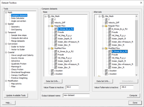
The Dataset Toolbox contains numerous tools for working with datasets. Once the options for the current tool have been set and a name for the resulting dataset has been specified, selecting the Compute, Sample, etc. button will create the new dataset. The name of the new dataset will appear in the list of datasets.
The Dataset Toolbox tools are organized as follows:
Temporal
Sample Times
Create a new dataset from sampled times of an existing dataset. If Interpolate times is selected, linear interpolation will be used to determine the sampled times. If Interpolate times is not selected, the value from the nearest existing dataset time step will be used.
Merge Datasets
Starting SMS 11.2, two or more datasets can be merged together. The selected datasets must not have any overlapping time steps.
Derivatives
Create a new dataset of the change from one time step to the next, or the derivative from one time step to the next of an existing dataset. When computing a derivative, the time units must be specified. The the new dataset will output data in between the existing dataset time steps, resulting in one fewer time step than the original dataset.
Math
Compare
Compare two datasets by subtracting the "Alternate" dataset from the "Base" dataset. User specified NULL values are assigned if the base or alternate dataset is inactive.
Data Calculator
For more information, see Data Calculator.
Angle Convention
Create a new dataset with a different angle convention from a scalar dataset containing directions in a given angle convention. With datasets for CMS-WAVE and STWAVE cartesian grids, the angle can be converted to and from a shore normal convention.
Spatial
Geometry
- Gradient
- Creates a function that gives the gradient at each node. The gradient is calculated as the run divided by the rise.
- Gradient Angle
- Creates a function that gives the direction in degrees of the maximum gradient at each point.
- Directional Derivative
- Creates a vector function that gives the gradient (run/rise) in the x and y directions.
Smoothing Datasets
For more information, see Smooth Dataset.
Grid Spacing
Creates a function that gives the average distance between a node and its neighbors.
Conversion
Scalar to Vector
Converts two scalar datasets to a single vector dataset. The specified scalar datasets can be either magnitude and direction or x and y components.
Vector to Scalar
Converts a single vector dataset into two scalar datasets. The resulting scalar datasets can be either magnitude and direction or x and y components.
Coastal
Local Wave Length and Celerity
Creates two functions that calculate the celerity and wavelength at each node for any depths.
.
.
Gravity Waves (Courant or Time Steps)
Creates a function that gives the courant number for each node given the Time Step, or the gravity wave time step given the Courant Number.
- .
- .
Advective (Courant or Time Steps)
Advective requires a vector function as input and is disabled if no vector functions exist. The courant option creates a function that calculates the courant number given the Time Step and a velocity function. The time step option creates a function that calculates the time step given the Courant Number and a velocity function.
- .
- .
Modification
Map Activity
This maps the activity array from one dataset to second dataset. This may be used to show only the values of interest on a particular dataset. This operation creates a new dataset.
Filter
This creates a new dataset based on specified criteria. The following options are available for filtering:
- < (less than)
- <= (less than or equal to)
- > (greater than)
- >= (greater than or equal to)
- equal
- not equal
- null
- not null
If the value passes the specified filter, the following can be assigned:
- original (no change)
- specify (a user specified value)
- null (the dataset null value)
- true (1.0)
- false (0.0)
- time – The first time the condition was met. Time can be specified in seconds, minutes, hours or days, and includes fractional values (such as 3.27 hours).
In addition, if the value passes none of the criteria, a default value can be assigned (see available options above).
The filtering is applied in the order specified. This means as soon as the new dataset passes a test, it will not be filtered by subsequent tests.
Related Links
SMS – Surface-water Modeling System | ||
|---|---|---|
| Modules: | 1D Grid • Cartesian Grid • Curvilinear Grid • GIS • Map • Mesh • Particle • Quadtree • Raster • Scatter • UGrid |  |
| General Models: | 3D Structure • FVCOM • Generic • PTM | |
| Coastal Models: | ADCIRC • BOUSS-2D • CGWAVE • CMS-Flow • CMS-Wave • GenCade • STWAVE • WAM | |
| Riverine/Estuarine Models: | AdH • HEC-RAS • HYDRO AS-2D • RMA2 • RMA4 • SRH-2D • TUFLOW • TUFLOW FV | |
| Aquaveo • SMS Tutorials • SMS Workflows | ||


