SMS:SRH-2D Sediment Material Properties
The SRH-2D model has specific sediment materials requirements. When the SRH-2D Sediment Material coverage is active, the options in this section change.
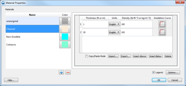
Each material polygon or group of polygons is assigned multiple sediment layers. Layers are added using the Insert Above and Insert Below buttons. A selected layer can be removed using the Delete button. Layers can also be added using the Import to bring layer data from a text file. The Copy/Paste Mode also pasting data from another program or copying the data to another program.
Each layer can specify a Thickness, thickness Units, site dry bulk Density, and sediment Gradation Curve.
A minimum of two layers is recommended even if the bed material is vertically uniform: one relatively thin layer to interact with the sediment transport and a thicker sediment reservoir. In sand bed rivers the two layers typically have the same densities and gradations. For gravel bed rivers the upper layer can represent a coarse surface armor and the deeper layer is the subsurface gradation.
Related Topics
SMS – Surface-water Modeling System | ||
|---|---|---|
| Modules: | 1D Grid • Cartesian Grid • Curvilinear Grid • GIS • Map • Mesh • Particle • Quadtree • Raster • Scatter • UGrid |  |
| General Models: | 3D Structure • FVCOM • Generic • PTM | |
| Coastal Models: | ADCIRC • BOUSS-2D • CGWAVE • CMS-Flow • CMS-Wave • GenCade • STWAVE • WAM | |
| Riverine/Estuarine Models: | AdH • HEC-RAS • HYDRO AS-2D • RMA2 • RMA4 • SRH-2D • TUFLOW • TUFLOW FV | |
| Aquaveo • SMS Tutorials • SMS Workflows | ||
