SMS:CMS-Wave Model Control
From XMS Wiki
Jump to navigationJump to search
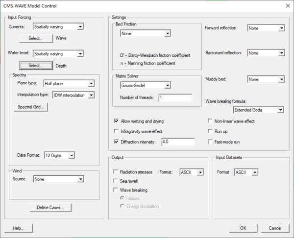
The Model Control… command in the CMS-Wave Menu opens the CMS-Wave Model Control dialog. This dialog is divided into sections for different types of parameters which are used by the model as it runs. These include:
Input Forcing
- Currents – A vector dataset can be used to define the currents for the simulation
- Water Level – A constant value or a scalar dataset can be used to define the water level for the simulation. If “constant” is selected, the constant value will be defined in the CMS-Wave Case Definition dialog for each case.
- Spectra
- Plane Type – this option is only used if the Spatially Varied source option is selected.
- "Half plane" – appropriate for nearshore coastal applications allowing wave input and generation on two boundaries resulting in a faster run-time.
- "Full plane" – used with enclosed or semi-enclosed bays, estuaries, and lakes where there is no clear “offshore” direction and seas and swells may oppose each other. Allows wave input and geration on all four boundaries.
- "Full plane with input reverse spectra" – this option allows spectral input to be used on two opposite boundaries.
- Interpolation Type – sets the method for STWAVE to use when interpolating between spectra.
- "Average spectra"
- "IDW interpolation" – Inverse Distance Weighting
- Spectral Grid
- Create Nesting Points – if the From parent grid source option is selected and a parent grid has been specified, clicking on this button will allow specifying which points should be used from the parent grid for creating the nesting file.
- Plane Type – this option is only used if the Spatially Varied source option is selected.
- Wind – a constant value or a vector dataset can be used to define the wind for the simulation. If constant is selected, the wind direction and magnitude will be specified in the CMS-Wave Case Definition dialog for each case.
- Define Cases
Settings
The settings section is used to specify model input options including:
- Bed friction
- Matrix Solver
- Gauss-Seidel
- ADI
- Allow wetting and drying
- Infragravity wave effect
- Diffraction intensity
- Forward reflection – A constant value for the entire simulation or spatially varying data using a scalar dataset can be used to define the forward reflection for the model.
- Backward reflection – A constant value for the entire simulation or spatially varying data using a scalar dataset can be used to define the backward reflection for the model.
- Muddy bed – Spatially varying data using a scalar dataset can be used to define the muddy bed (values??) for the model.
- Non-linear wave effect
- Run up
- Quick mode
Output
This section is used to specify option output from the model. The output includes:
- Radiation stresses
- Sea/Swell
- Wave Breaking
Input Datasets
Here specify the format for SMS to write out the input datasets. They can be written in either ASCII or XMDF format.
Related Topics
SMS – Surface-water Modeling System | ||
|---|---|---|
| Modules: | 1D Grid • Cartesian Grid • Curvilinear Grid • GIS • Map • Mesh • Particle • Quadtree • Raster • Scatter • UGrid |  |
| General Models: | 3D Structure • FVCOM • Generic • PTM | |
| Coastal Models: | ADCIRC • BOUSS-2D • CGWAVE • CMS-Flow • CMS-Wave • GenCade • STWAVE • WAM | |
| Riverine/Estuarine Models: | AdH • HEC-RAS • HYDRO AS-2D • RMA2 • RMA4 • SRH-2D • TUFLOW • TUFLOW FV | |
| Aquaveo • SMS Tutorials • SMS Workflows | ||
