GMS:MF6 UZF Package
From XMS Wiki
Jump to navigationJump to search
| This contains information about functionality available starting at GMS version 10.5. The content may not apply to other versions. |
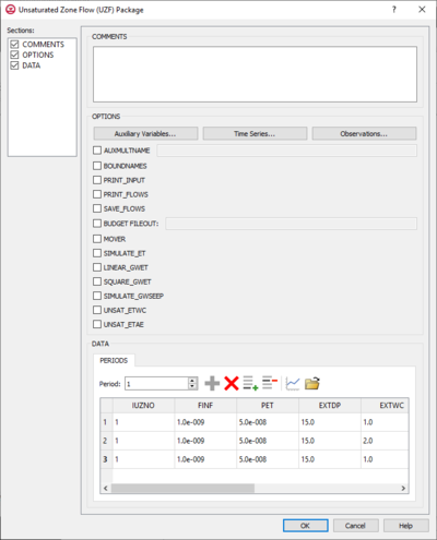
The Unsaturated Zone Flow (UZF) Package dialog is accessed by double-clicking on the WEL package under a MODFLOW 6 simulation in the Project Explorer. It contains the following sections and options:
- Sections list – A list of sections that can be turned on or off:
- Comments – Turn on to make the Comments section visible.
- Options – Turn on to make the Options section visible.
- Data – Turn on to make the Data section visible. This section is on by default.
- Comments section – Enter general alphanumeric comments. Comments entered here get written at the top of the file, preceded by a '#' symbol.
- Options section – Temporal options and settings:
- Auxiliary Variables... – Click to bring up the Auxiliary Variables dialog.
- Time Series... – Click to bring up the Time Series Files dialog.
- Observations... – Click to bring up the Observation Files dialog.
- AUXMULTNAME – The name of the auxiliary variable.
- BOUNDNAMES – If turned on, indicates that the list of UZF cells will be provided with the associative boundary names.
- PRINT_INPUT – If turned on, indicates that the list of UZF information will be written to the listing file after it is read.
- PRINT_FLOWS – If turned on, indicates that a list of UZF flow rates will be printed to the listing file.
- SAVE_FLOWS – If turned on, indicates that the UZF flow terms will be written to a specified file.
- BUDGET_FILEOUT – Allows the specification of a file to which desired flow terms will be written.
- MOVER – When turned on, indicates that the Unsaturated Zone Flow (UZF) Package, in this instance can be used in collaboration with the Water Mover (MVR) Package.
- SIMULATE_ET – If turned on, this indicates that ET will be simulated.
- LINEAR_GWET – If turned on, indicates that groundwater ET will be simulated.
- SQUARE_GWET – If turned on, indicates that groundwater ET will be simulated by assuming a constant ET rate.
- SIMULATE_GWSEEP – If turned on, indicates that groundwater discharge to land surface will be simulated.
- UNSAT_ETWC – If turned on, indicates that ET in the unsaturated zone will be simulated as a function of the specified PET rate.
- UNSAT_ETAE – If turned on, indicates that ET in the unsaturated zone will be simulated simulated using a capillary pressure based formulation.
- Data section – Contains the following:
- Periods drop-down – Use the Increment Up and Down
 buttons to select the desired period.
 - Define Period
 – If no period is defined, click to make the spreadsheet editable.
 - Delete Period
 – Click to delete the existing period.
 - Add Rows
 – Click to bring up the Add Stresses dialog.
 - Delete Rows
 – Click to bring up a dialog with three options:
- Delete from All Periods – Click to delete matching stresses from all periods.
- Delete from Just This Period – Click to delete matching stresses from just this period.
- Plot All Periods
 – Click to bring up the XY Series Editor dialog. Requires that a cell be selected in the table.
 - Open Time Series
 – Click to bring up the
 - Filter on Selected Cells
 – Click to turn on filtering on the selected cells.
- Table – Allows the manual input of different variables for the UZF Package.
- IUZNO – An integer value that defines the UZF cell number associated with the specified PERIOD data on the line.
- FINF – A value that defines the applied infiltration rate of the UZF cell.
- PET – A value that defines the ET rate of the UZF cell and specified GWF cell.
- EXDP – A value that defines the ET extinction depth of the UZF cell.
- EXTWC – A value that defines the amount of water removed from the UZF cell through evapotranspiration.
- HA – A value that defines the amount of potential air that enters the UZF cell.
- HROOT – A value that defines the root potential of the UZF cell.
- ROOTACT – A value that defines how much root activity exists in the UZF cell.
- Table – Allows the manual input of different variables for the UZF Package.
- Periods drop-down – Use the Increment Up and Down
Related Topics
GMS – Groundwater Modeling System | ||
|---|---|---|
| Modules: | 2D Grid • 2D Mesh • 2D Scatter Point • 3D Grid • 3D Mesh • 3D Scatter Point • Boreholes • GIS • Map • Solid • TINs • UGrids | |
| Models: | FEFLOW • FEMWATER • HydroGeoSphere • MODAEM • MODFLOW • MODPATH • mod-PATH3DU • MT3DMS • MT3D-USGS • PEST • PHT3D • RT3D • SEAM3D • SEAWAT • SEEP2D • T-PROGS • ZONEBUDGET | |
| Aquaveo | ||
