SMS:SRH-2D Model Control
The SRH-2D Model Control dialog can be reached by using the Model Control command in the SRH-2D menu. From the model control, enter data that will be written to the files used by SRH-2D for computation.
General Tab
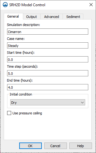
In the General tab, specify the name of the case used for the SRH-2D model run. The following options are available:
- Simulation Description – For noting information that may be useful later when reviewing the model. Information entered as the Simulation Description are not used the SRH-2D model for computation.
- Case Name – A keyword that SRH-2D will use to link files together of the same case. A simple word without spaces is needed by the model. To avoid confusion, it is a good practice to name the Case Name the same as the simulation name.
- Start Time (hours) – The default is left at zero, but it may need to be adjusted to meet the time specifications of input hydrographs or other data.
- Time Step (seconds) – Used by SRH-2D to make calculations. Depending on the model, the element size, and the input parameters, the time step will need to be adjusted. The time step should be selected to maintain hydraulic computational stability during the model run. Monitor Points can be used to track model stability.
- End Time (hours) – Determines the total period of time the simulation run will analyze. The simulation end time depends on the type of simulation and the characteristics of the channel and bed material. Steady flow simulations can be run for long periods to reach equilibrium transport and bed elevation conditions, or for a representative amount of time the flow could occur. Hydrograph simulations should include a sufficient amount of time before and after the peak to adequately represent the range of flows.
- Initial Condition – Communicates to SRH-2D how each cell is to be treated upon launch. The following options are available:
- "Dry" – The default setting in SMS. This suggests that each element does not have water or is not wet.
- "Initial Water Surface Elevation" – Allows changing the Initial Water Surface Elevation for the simulation run. This sets the water surface elevation for all elements to one value. If the elevation at an element is greater than the water surface elevation specified, then the element is dry.
- "Automatic" – Assumes backwater from the downstream boundaries with areas above this value are dry.
- "Restart File" – Activates a Select button which brings up a browser to select an RST file from a previous run on the same mesh as the initial condition for each element. When a simulation is run, SRH-2D will write out a restart file for each output interval as specified in the Output tab. A Restart file is strongly recommended for unsteady (hydrograph) models in general and necessary for sediment transport models. The restart file is created by SRH-2D in a previous simulation using the same mesh and a hydraulic condition that is identical or very similar to the conditions at the start of the run for which the restart file will be used. In the case of a sediment transport analysis, if no restart file is provided, meaningless erosion and/or deposition would occur during the time period when the hydraulic results are converging.
- Starting with SMS version 13.3, specifying the use of a restart file will also add the restart code to the DIP file so that SRH-2D will make full use of the restart data. When this option is used the starting time of the simulation will come from the restart file.
- Note: restart files are not compatible across versions of SRH and will cause SRH to print an error and stop the simulation. When a project is migrated to a new version of SRH it is necessary to re-run SRH and create new restart files.
- Use ceiling file – Checking this option changes the SRH-2D mode of computing pressure flow. With this option off, the model uses the traditional pressure zones defined in the boundary condition coverage. With this option on, the model uses a ceiling dataset file. SMS creates this dataset, consisting of a specified ceiling elevation for each cell which has a ceiling, from user selected 3D bridges. The specified profile of the bridge provides these ceiling elevations.
- "Generate new ceiling file..." – Selecting this button allows the user to create a ceiling elevation to be used for pressure flow calculations. This requires that the simulation has a mesh, and that at least one 3D bridge coverage exists. The user selects the bridge or bridges that will be used for this simulation. Switching meshes requires that this dataset be recreated. To include a different bridge (or set of bridges) also requires that this process be redone.
Output Tab
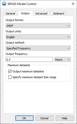
The Output tab has options that will tell SRH-2D what is to be written out as results and how often.
- Result Output Format – Specifies the type of file that will be written with results. SRH-2D determines the hydraulic and sediment transport results at element centroids, but can interpolate results to the nodes that form the elements. Results can be output either to the nodes or element centroids. SMS currently only supports nodal based output for post processing. SRH-2D supports and writes out to the following file formats:
- XMDF – This is the default results format for storing and viewing SRH-2D results in SMS. The results are reported at the nodes and all timesteps are in a single file. SRH-2D actually creates a solution file with values computed at element centroids with an extension of xmdfc.h5. The SRH-Post program interpolates the solution values to the nodes, making adjustments for the edge of the mesh and lips of embankments. The output of SRH-Post is a solution file with an extension of xmdf.h5. The xmdfc.h5 file can be loaded into SMS onto a UGrid to allow visualization of the SRH-2D computed cell center values.
- SRHN – This is a coma delimited text file format with one file per output time step. Results are reported a the nodes and can be brought into SMS through the File Import Wizard.
- SRHC – Same as SRHN, but the result are reported at the element centroids.
- TECPlot – TECPlot is a 3rd party proprietary visualization and analysis software developed by Tecplot. This is a TECPlot native data format and can be viewed in the TECPlot viewer.
- Paraview – Paraview is an open source multi-platform visualization package. This is a Paraview native data format and can be viewed in the Paraview viewer.
- Result Output Unit – Option dictates to SRH-2D the units to be included in the output file whether they be English or International (SI) units.
- Result Output Method – Allows the following options:
- Specified Frequency
- Specified Time
- Simulation End
- Result Output Fequency (hours) – User specifies how frequently the solution from the simulation should be saved (in simulation time). This edit field is available only if the Specify Frequency option is selected.
Advanced Tab
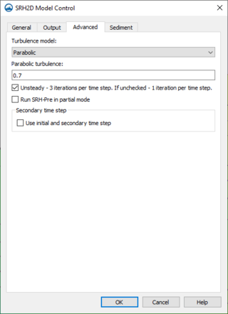
Under the Advanced tab are the options for the turbulence model used in the simulation. The current release of SRH-2D support the use of the the following turbulence models:
- Laminar
- Constant
- Parabolic
- KE
Using "Parabolic" requires the input of a constant for the turbulence equation. The default value is left as "0.7". Consult the SRH-2D User’s Manual or other reference materials to find the value that is most appropriate for their run.
- Unsteady - 3 iterations per time step. If unchecked - 1 iteration per time step) – SRH-2D always includes a transient component to its calculations. Selecting this option instructs SRH-2D to perform 3 iterations per time step which results in a more converged solution at each timestep. This is recommended for simulations with changing boundary conditions (i.e. hydrographs). If this option is off, SRH-2D performs a single iteration per time step. This means that while the solution is tending to a converged, stable solution, the solution may not be converged when the solution is changing rapidly, such as at the start of the simulation when initial conditions are applied that may not be realistic. When running in Steady mode (with this toggle unchecked), it is recommended to change the output method to “Simulation End.” Fewer iterations in Steady mode allow for shorter (more economical) computation time. The difference lies between the intermediate results. The final results of a steady or unsteady analysis should be the same; however, unsteady allows for accurate intermediate results.
- Run SRH-Pre in partial mode – This option allows experienced users of SRH-2D to customize the script input file (SIF) for a simulation. If this option is selected, SMS will launch SRH-Pre to use the SIF file rather than the *.srhhydro file created by SMS. Using this option ignores any changes made to the simulation since the SIF file was generated. Therefore, extreme care should be exercised when using this option. (Note: a typical run of SRH-Pre (with this option off) creates an SIF file which can then be customized in a text editor.)
- Use initial and secondary time step – This option uses the SRH-2D DIP file to modify the time step size during the simulation run. This is a modification to the time step size specified on the General tab of the SRH-2D Model Control dialog. This feature may be result in more efficient simulation execution because a the start of a simulation often includes more radical changes in hydraulic conditions, and therefore may require a small time step. However, after the simulation has reached an equilibrium, and changes are more gradual, a larger time step often suffices. This option is a first iteration allowing a changing time step. The user specifies the secondary time step (in seconds) and the simulation time (in hours) when the time step should switch from the initial specified time step to the secondary time step. Determining these parameters may require some iteration.
Sediment Tab
See SRH-2D Sediment Transport Parameters for more information.
Related Topics
SMS – Surface-water Modeling System | ||
|---|---|---|
| Modules: | 1D Grid • Cartesian Grid • Curvilinear Grid • GIS • Map • Mesh • Particle • Quadtree • Raster • Scatter • UGrid |  |
| General Models: | 3D Structure • FVCOM • Generic • PTM | |
| Coastal Models: | ADCIRC • BOUSS-2D • CGWAVE • CMS-Flow • CMS-Wave • GenCade • STWAVE • WAM | |
| Riverine/Estuarine Models: | AdH • HEC-RAS • HYDRO AS-2D • RMA2 • RMA4 • SRH-2D • TUFLOW • TUFLOW FV | |
| Aquaveo • SMS Tutorials • SMS Workflows | ||


