GMS:Boreholes
From XMS Wiki
Types of Borehole Data
A borehole can contain either stratigraphy data or sample data or both.
Stratigraphy
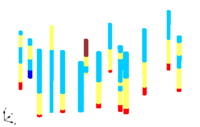
Stratigraphy data are used to represent soil layers that are encountered in a soil boring. The soil layers are represented using contacts and segments as shown below. A segment represents a soil layer and a contact is the interface between two segments.
File:Holes1.gif
Boreholes Representing Soil Stratigraphy With Contacts And Segments
Sample Data
Sample data represent data obtained by continuous sampling along the length of the hole. Cone penetrometer data and down-hole geophysical data are examples of sample data. The figure below shows an example of sample data being displayed. Sample data are stored in data sets which can be manipulated in a similar fashion as other data sets in GMS.
File:Sampledata1.gif
Boreholes with Sample Data
| GMS – Groundwater Modeling System | ||
|---|---|---|
| Modules: | 2D Grid • 2D Mesh • 2D Scatter Point • 3D Grid • 3D Mesh • 3D Scatter Point • Boreholes • GIS • Map • Solid • TINs • UGrids | |
| Models: | FEFLOW • FEMWATER • HydroGeoSphere • MODAEM • MODFLOW • MODPATH • mod-PATH3DU • MT3DMS • MT3D-USGS • PEST • PHT3D • RT3D • SEAM3D • SEAWAT • SEEP2D • T-PROGS • ZONEBUDGET | |
| Aquaveo | ||
Retrieved from "https://www.xmswiki.com/index.php?title=GMS:Boreholes&oldid=28636"
Hidden category:
