Search results
From XMS Wiki
Jump to navigationJump to search
Page title matches
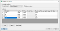
- ...g GSSHA Overland Soil Erosion.png|thumb|right|500 px|GSSHA ''Overland soil erosion'' dialog.]] ...il erosion'' in the other options section of the [[WMS:GSSHA Job Control|''GSSHA Job Control Parameters'' dialog]] and clicking the '''Edit parameter...'''4 KB (582 words) - 19:39, 17 May 2019
- #REDIRECT [[WMS:GSSHA Overland Soil Erosion]]45 bytes (6 words) - 16:32, 5 September 2013
Page text matches
- #REDIRECT [[WMS:GSSHA Overland Soil Erosion]]45 bytes (6 words) - 16:32, 5 September 2013
- #REDIRECT [[WMS:GSSHA Overland Soil Erosion]]45 bytes (6 words) - 16:32, 5 September 2013
- #REDIRECT [[WMS:GSSHA Overland Soil Erosion]]45 bytes (6 words) - 16:32, 5 September 2013
- #REDIRECT [[WMS:GSSHA Overland Soil Erosion]]45 bytes (6 words) - 16:32, 5 September 2013
- #REDIRECT [[WMS:GSSHA Overland Soil Erosion]]45 bytes (6 words) - 18:58, 17 May 2019
- #REDIRECT [[WMS:GSSHA Overland Soil Erosion]]45 bytes (6 words) - 16:33, 5 September 2013
- #REDIRECT [[WMS:GSSHA Overland Soil Erosion]]45 bytes (6 words) - 16:33, 5 September 2013
File:Dialog GSSHA Overland Soil Erosion.png [[Category:GSSHA]] [[Category:GSSHA Dialogs]](708 × 364 (9 KB)) - 22:52, 25 October 2022- |name = GSSHA Wiki |title = [[WMS:GSSHA|GSSHA]]2 KB (303 words) - 21:52, 21 May 2019
- ...g GSSHA Overland Soil Erosion.png|thumb|right|500 px|GSSHA ''Overland soil erosion'' dialog.]] ...il erosion'' in the other options section of the [[WMS:GSSHA Job Control|''GSSHA Job Control Parameters'' dialog]] and clicking the '''Edit parameter...'''4 KB (582 words) - 19:39, 17 May 2019
- To include inputs for sediment transportation in a long-term [[WMS:GSSHA|GSSHA]] model, do the following: :#Open [[WMS:GSSHA Job Control|'''Job Control...''']], turn on ''Soil erosion'' and select '''Edit parameter...'''.2 KB (277 words) - 20:19, 4 May 2023
- ...establish the computational domain and parameters for surface runoff. The GSSHA model is fully coupled with hydraulic stream flow/routing models. Parameter ...lows GSSHA to model basins in both arid and humid environments."<ref name="GSSHA overview"/>4 KB (544 words) - 14:44, 7 May 2024
- * {{done}} [[WMS:GSSHA Calibration|Calibration]] ***Split into [[WMS:GSSHA Automated Calibration|Automated]] and [[WMS:GSSHA Manual Calibration|Manual]]9 KB (1,379 words) - 22:53, 22 July 2020
- ...y required process, which is always included in every GSSHA simulation, is overland flow. *'''Output Control...''' – Opens the [[WMS:GSSHA Output Control|''GSSHA Output Control'' dialog]].9 KB (1,269 words) - 19:15, 17 May 2019
- [[File:Dialog_GSSHA_Output_Control.png|thumb|right|360 px|''GSSHA Output Control'' dialog.]] ...f these datasets will be imported into to WMS, if they exist, as part of a GSSHA solution.5 KB (822 words) - 18:09, 17 May 2019
- Feature points and nodes in GSSHA have several attributes that can be modified. The ''Properties'' dialog all ...s not displayed in the dialog. This dialog for feature points and nodes in GSSHA lists the various attributes associated with each feature point or note.6 KB (1,029 words) - 22:06, 7 July 2020
- You can enter in the initial soil moisture using an index map basing it on soil type, land use, or both. When running in continuous simulation mode, the m The model uses the same grid that is used for overland flow.5 KB (793 words) - 19:29, 23 March 2020
- ...tributed parameters for options specified in the [[WMS:GSSHA Job Control|''GSSHA Job Control'' dialog]]. The mapping tables relate parameter sets for each p ...sets. Some of the tabs require the option to have been turned on in the ''GSSHA Job Control'' dialog. If the tab is selected and the option has not been tu33 KB (4,910 words) - 19:11, 17 May 2019
- ...to the '''2D Grid''' [[File:2D Grid Icon.svg|16px]] module and selecting ''GSSHA'' | '''Maps...''' to bring up the dialog. *'''Done''' – Saves any changes and exits the ''GSSHA Maps'' dialog.8 KB (1,291 words) - 22:05, 9 May 2019
- ;6.2. Gridded Surface Subsurface Hydrologic Analysis (GSSHA) :[[WMS:GSSHA|GSSHA]]9 KB (1,250 words) - 19:04, 5 May 2022
